
- Home
- »
- Next Generation Technologies
- »
-
LiDAR Services Market Size And Share Report, 2026-2033GVR Report cover

LiDAR Services Market (2026 - 2033)
Size, Share & Trends Analysis Report By Service Type (GIS Service, Asset Management, Aerial Surveying, Ground-based Surveying, Mapping, Modelling), By Application (Corridor Mapping, Engineering), By Region, And Segments Forecasts
Market Size, 2025
$3.8BMarket Estimate, 2026
$4.7BMarket Forecast, 2033
$19.5BCAGR, 2026–2033
22.7%LiDAR Services Market Summary
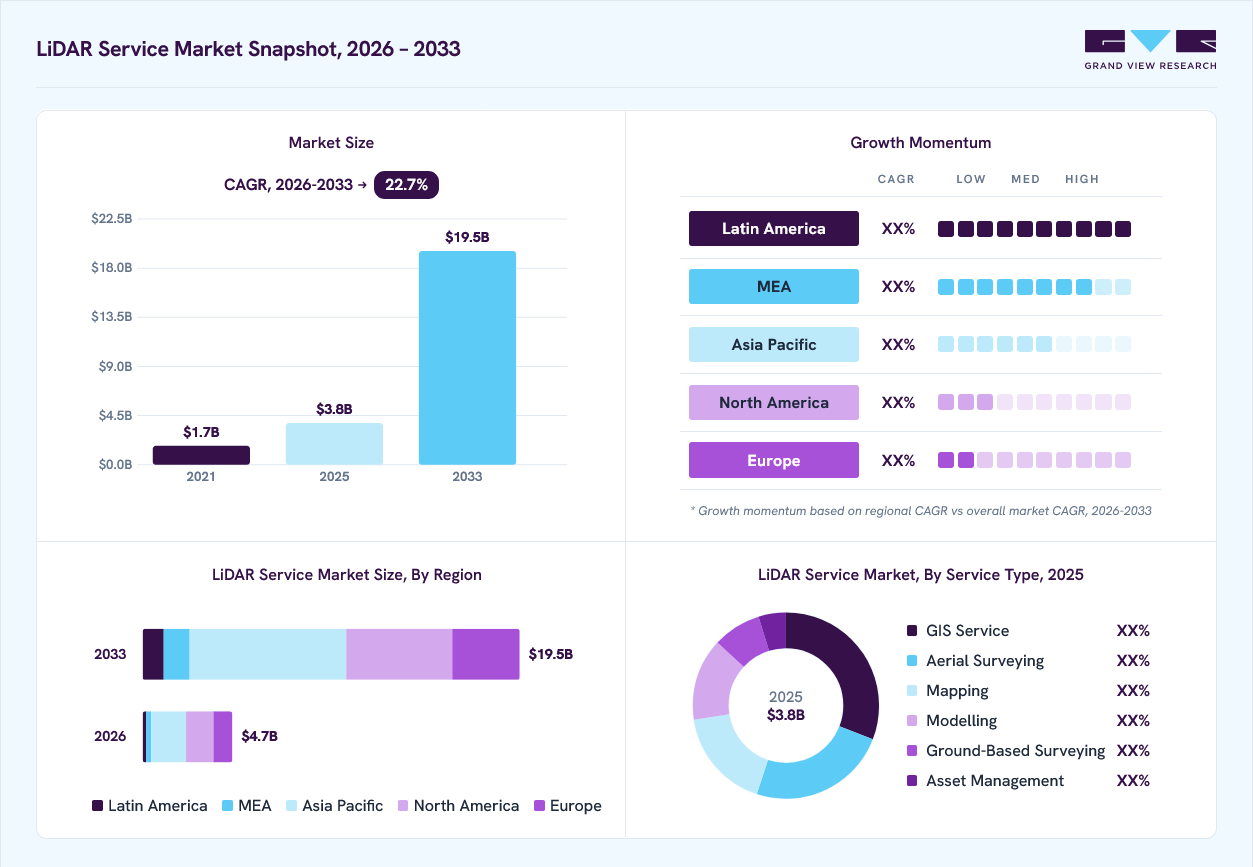
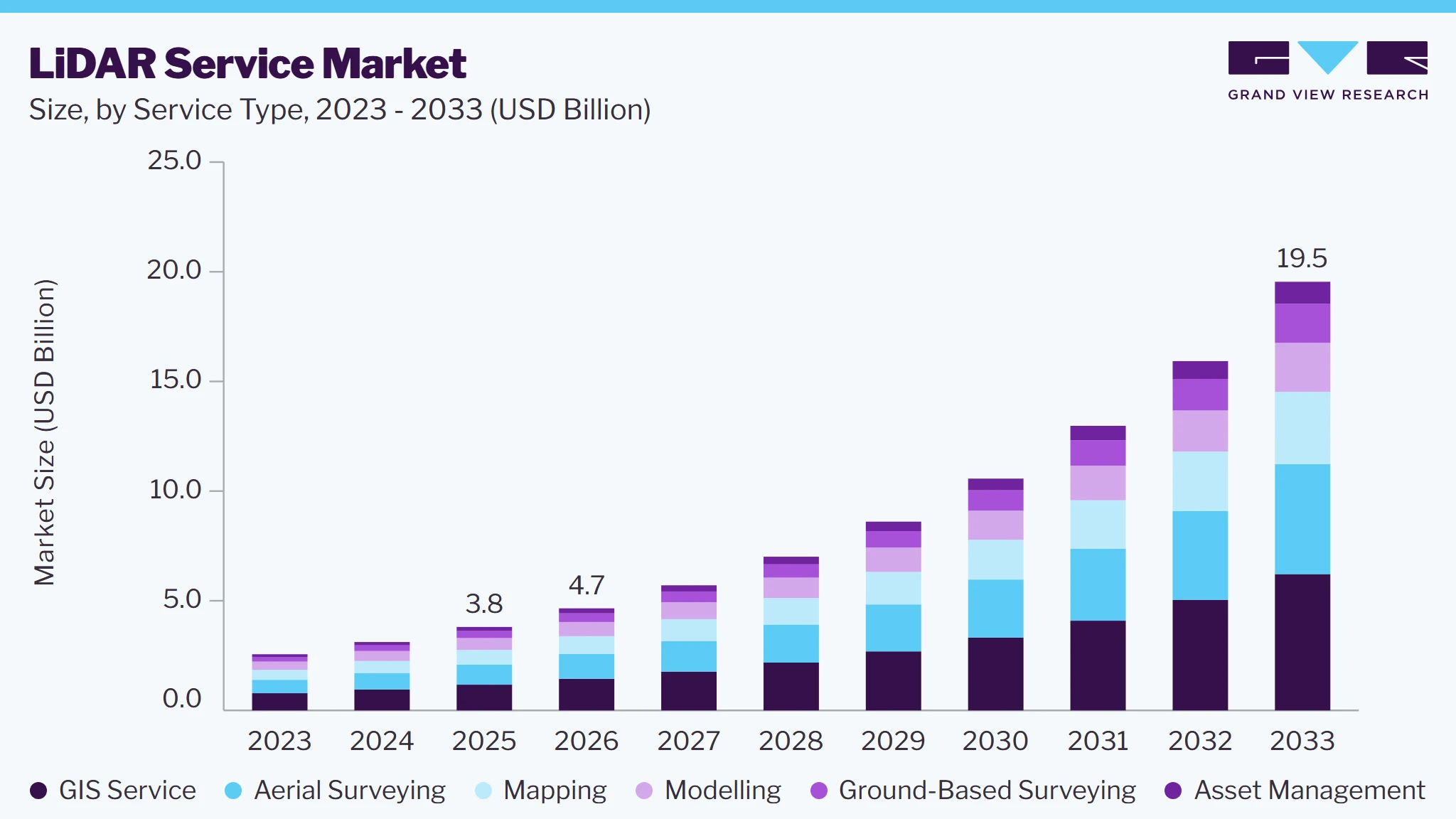
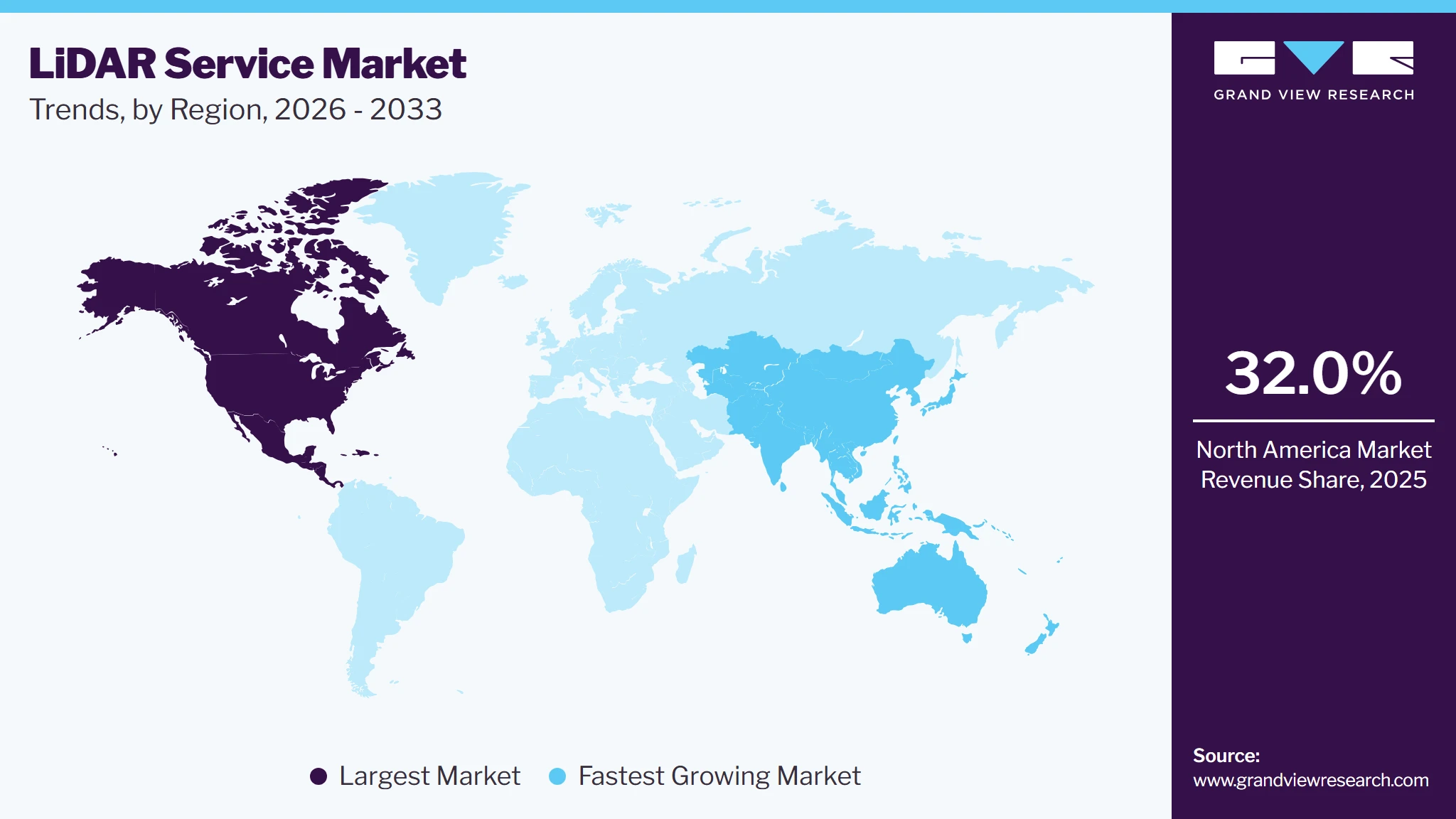
The global LiDAR services market size was valued at USD 3.8 billion in 2025 and is projected to grow from USD 4.7 billion in 2026 to USD 19.5 billion by 2033, at a CAGR of 22.7% from 2026 to 2033. North America accounted for the largest share of 32.0% in the global market, representing the highest revenue contribution in 2025. The growth is driven due to investments in transportation infrastructure, smart cities, and utility netnetworks, and high-resolution geospatial mapping increase demand for accurate 3D spatial data.
 Source: Grand View Research, IR Documents, Primary Interviews, Paid DatabasesTo learn more about this report,
 Download Free Sample Report
Key Market Trends & Insights
- By service type: GIS Service segment led the market and held the largest revenue share of over 30.8% in 2025.
- By application: corridor mapping segment led the market and held the largest revenue share of over 35.0% in 2025
Regional Highlights
- Largest regional market: North America (32.0% revenue share, 2025)
- Fastest-growing regional market: Asia Pacific (highest CAGR,2026-2033)
- By country: The U.S. held the largest market share in 2025
Market Size & Forecast
- Market size in 2025: USD 3.8 Billion
- Estimated market size in 2026: USD 4.7 Billion
- Projected market size by 2033: USD 19.5 Billion
- CAGR (2026-2033): 22.7%
Prism AI by Grand View Research Free to tryAsk a question about the LiDAR services marketTry asking✓Every figure cited from GVR research Prefer the report? Download free sample →
Adoption of UAV-based and mobile LiDAR surveying is expanding due to faster data collection, improved accessibility, and greater operational flexibility. Government-led elevation mapping programs and rising requirements for flood-risk assessment, environmental monitoring, and infrastructure planning are creating sustained demand for LiDAR services. The strong presence of leading AI technology companies, cloud providers, autonomous vehicle developers, and research institutions further accelerates innovation and the deployment of advanced data annotation platforms.This is further employed in the inaccessible, remote, and forest areas, to compile the ground information and bare-earth feature. The technology uses light energy that is emitted from a laser, which is used to measure variable distances and scan the ground. The growing use of 3D imaging technology for robotics and medical imaging is expected to boost the market growth.
 To learn more about this report, Download Free Sample Report
The LiDAR services are supported by 3D imaging technologies such as textured 3D imaging, which are used in various applications such as 3D mapping and city planning. The adoption of 3D imaging technology is positively influencing market growth, owing to the considerable need for LiDAR data processing and mapping services while implementing 3D imaging. Several major players in the market have partnered or acquired LiDAR service providers to increase the scope of vertical integration in the market. For instance, In May 2017, Trimble Inc. acquired Network Mapping Inc., a LiDAR services provider. This acquisition helped the former company to expand its portfolio of energy solutions, through which, it was able to offer 3D visualization services and high-value data modeling for the utility sector.
Further, LiDAR services are growing significantly in the U.S. and Germany, as the transportation agencies are adopting this technology for transportation-related applications such as public transportation including self-driving cabs or autonomous truck fleets. Moreover, rising technological advancement in user interface and diagnostic features for detecting malfunctioning of the LiDAR sensors is expected to boost the market growth. Also, there are significant advancements registered in the inertial measurement unit (IMU) technique to provide highly accurate elevation measurements.
The market has faced some challenges owing to data and privacy issues associated with LiDAR services. The inefficiency of LiDAR services and lack of appropriate customer awareness are factors restraining the growth of the market. Other services such as aerial surveying require UAV, which poses a threat of privacy issues due to the continuous monitoring of the public with drones. Growing awareness of identity protection as well as the risks involved, among customers, is also negatively influencing the market growth.
Market Dynamics
Market dynamics in the LiDAR services market are shaped by the trade-off between survey accuracy, project cost, data quality, and delivery timelines. Increasingly stringent specifications for positional accuracy, point density, and quality assurance are influencing vendor selection, favoring providers with established technical expertise and standardized workflows. High capital requirements for sensors, aircraft, calibration, and specialist personnel create entry barriers for smaller service providers, while large-scale procurement contracts enable established firms to achieve economies of scale. Data storage, processing complexity, interoperability, and integration with clients’ existing systems remain significant operational challenges. The availability of publicly funded LiDAR datasets can also constrain demand for basic mapping in already surveyed areas, shifting commercial opportunities toward specialized deliverables and updated data products. In addition, project economics vary with terrain, vegetation density, site accessibility, and the accuracy requirements specified by customers. Providers are increasingly differentiating themselves through automated quality checks, efficient data workflows, and application-specific deliverables. Over the longer term, recurring survey contracts, advanced feature extraction, and specialized processing services offer opportunities to improve customer retention and revenue consistency.
Government-led geospatial mapping initiatives are driving demand in the LiDAR services market as countries invest in high-resolution elevation data, digital land records, and standardized national mapping systems. Programs such as the U.S. Geological Survey’s 3D Elevation Program (3DEP) create opportunities for private service providers to undertake LiDAR data acquisition, processing, and quality validation. In India, initiatives such as NAKSHA incorporate advanced geospatial technologies, including 3D LiDAR scanning, to modernize urban land records and property mapping. hese programs generate demand for specialized surveying expertise, terrain modeling, and GIS-ready datasets used by government departments and planning agencies. Public-sector contracts can also provide service providers with large-scale project opportunities and more predictable demand. However, the availability of publicly accessible mapping data may limit repeat surveys in already covered areas, encouraging providers to focus on data updates and specialized analytical services.
LiDAR service delivery can be affected by adverse weather, dense vegetation, difficult terrain, and positioning inaccuracies, which may reduce data reliability or require supplementary ground surveys. Achieving the required spatial accuracy also involves calibration, ground-control measurements, point-cloud classification, and rigorous quality validation. These requirements can extend project timelines and increase operational costs, particularly for large-scale or technically demanding surveying assignments.
The growing adoption of digital twins and building information modeling (BIM) creates opportunities for LiDAR service providers to move beyond conventional surveying into integrated 3D asset modeling. LiDAR-derived point clouds can be converted into detailed, real-world representations of buildings, industrial facilities, transport networks, and urban infrastructure. These datasets help asset owners compare actual site conditions with design specifications, plan maintenance activities, and assess infrastructure modifications. Government-backed geospatial initiatives are also exploring digital twins for urban and infrastructure management, supporting demand for LiDAR-enabled modeling services.
Market Concentration & Characteristics
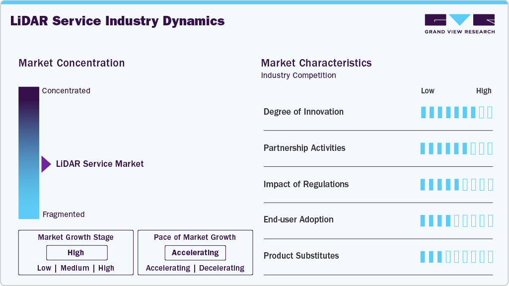
The global LiDAR services market is characterized by a competitive landscape comprising established geospatial service providers, specialized surveying firms, and technology-enabled mapping companies. Market participants compete based on data acquisition accuracy, survey coverage, point-cloud processing capabilities, GIS integration, project execution timelines, application expertise, and service pricing. Providers differentiate themselves through a broad range of capabilities spanning airborne, UAV-based, mobile, terrestrial, and bathymetric LiDAR surveying, supported by advanced mapping and geospatial analytics. Continuous advancements in AI-powered point-cloud classification, automated feature extraction, cloud-based geospatial processing, and digital twin integration are reshaping service delivery and creating opportunities for higher-value offerings. Strategic investments in advanced sensor systems, processing automation, multidisciplinary geospatial capabilities, and partnerships with infrastructure developers and government agencies are further influencing competitive positioning across the market.
 To learn more about this report, Download Free Sample Report
Key market participants in the Global LiDAR Services Market include Fugro, NV5 Geospatial, Woolpert, Dewberry, Surveying and Mapping, LLC (SAM), Kucera International, Sanborn Map Company, Ayres Associates, Merrick-Surdex, GPI Geospatial, Aero-Graphics, Martinez Geospatial, and Terra Remote Sensing. These companies focus on expanding their LiDAR service capabilities through investments in advanced airborne, UAV-based, mobile, terrestrial, and bathymetric surveying technologies; automated point-cloud processing; high-resolution 3D mapping; and GIS-enabled geospatial analytics. Their strategies emphasize improving data accuracy and processing efficiency, securing large-scale government and infrastructure contracts, developing application-specific mapping solutions, and integrating LiDAR outputs with digital twins, asset management systems, and engineering workflows. Service providers are also strengthening their capabilities in transportation infrastructure, utilities, environmental monitoring, flood-risk assessment, forestry, and urban planning to address diverse customer requirements and differentiate their offerings in the global market.
Analyst Perspective
The global LiDAR services market is witnessing robust growth as industries increasingly adopt advanced technologies across applications. However, the provided content primarily describes the data annotation tools market, driven by growing AI, machine learning, and generative AI adoption. Demand for high-quality labeled datasets, AI-assisted annotation, automated pre-labeling, and cloud-based platforms is improving model accuracy and operational efficiency. Growing applications in autonomous systems, healthcare, robotics, and multimodal AI are creating opportunities for scalable annotation solutions. Please verify the market name, as LiDAR services and data annotation tools are distinct markets.
Service Type Insights
Based on service type, the GIS service segment led the market with the largest revenue share of 30.8% in 2025, GIS services in the LiDAR services market are witnessing steady growth as organizations increasingly integrate high-resolution LiDAR data with geospatial mapping, spatial analytics, and asset management platforms. Rising demand for accurate 3D terrain models, digital elevation models, and detailed topographic mapping is driving adoption across infrastructure development, urban planning, utilities, and environmental monitoring. The integration of LiDAR with GIS enables faster data processing, improved visualization, and more informed decision-making for complex projects. Furthermore, growing investments in smart city development, transportation infrastructure, and climate resilience are strengthening demand for LiDAR-enabled GIS solutions.
These services have enabled users to generate aerial imaging data, which was earlier both complex and expensive to determine. LiDAR capable drone uses an automated GPS to make multiple passes over a low altitude area to collect data. This data is later used for various applications such as measuring volume, inspecting assets, and handling projects related to land and water management. The adoption of LiDAR services in drone operations, project management, data processing, and determining GPS control points, is anticipated to drive the market over the forecast period.
Application Insights
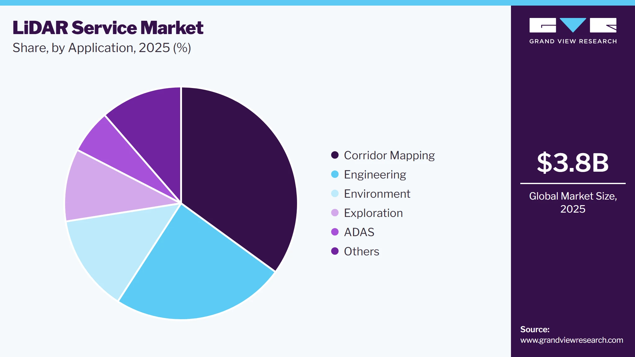
Based on application, the corridor mapping led the market with the largest revenue share of 35.0% in 2025. ADAS segment is estimated to gain the highest CAGR over the forecast period. The surging applicability of LiDAR in dynamic applications such as environment, engineering, and others is expected to drive the application segment, with future commercialization of the LiDAR systems.
 To learn more about this report, Download Free Sample Report
LiDAR services such as ground-based surveying and GIS are required to support ADAS in autonomous vehicles. Thus, increasing awareness about the benefits and adoption of LiDAR systems in self-driven vehicles, unmanned/manned aerial vehicles, building modeling, and 3D imagery, is expected to drive the market over the forecast period. Further, services such as the international LiDAR survey are used to collect data for photogrammetry, mapping, and other geospatial projects. Service providers assist their clientele by providing datasets that best suit their requirements. Thus rising adoption of such services in various industries including automotive, construction, and transportation is expected to deliver high growth opportunities for the market.
Regional Insights
The North America LiDAR services market accounted for the highest share, with over 32.0% of the global revenue in 2025. Based on the region, the market has been segmented as North America, South America, Europe, Asia Pacific, and MEA. In 2018, North America accounted for maximum share in the market, followed by the Asia Pacific and Europe. The Asia-Pacific regional market is expected to witness strong growth over the forecast period, owing to the rapidly increasing adoption of LiDAR systems in various applications and increasing investments by the government and several non-profit organizations.
 To learn more about this report, Download Free Sample Report
U.S. LiDAR Services Market Trends
The LiDAR services market in the U.S. held a dominant position in 2025.
Asia Pacific LiDAR Services Market Trends
The growing demand in emerging economies, such as India, Japan, and China, is driving the industry growth in the Asia Pacific region. Favorable government regulations and the growing automotive industry are some of the major factors driving the growth of the market in the Asia Pacific region. For instance, China’s Ministry of Industry and Information Technology (MIIT) has released a provision that 50% of all new vehicles must have partial or fully autonomous functions by 2022.
Key LiDAR Services Company Insights
The key industry participants are Fugro, GeoDigital, Harris Geospatial Solutions, Inc., Hexagon, Kucera International, Quanergy Systems, Inc., Quantum Spatial, Surdex Corporation, Trimble, Inc., and Terra Remote Sensing. The competitive rivalry among the existing players is high, and the rivalry is based on service differentiation and the cost. To retain their position in the market and rise above the price competitiveness, market leaders are focusing on investing in R&D facilities. However, maintaining profit margin and price competitiveness are some of the key concerns of the market. Besides, key automobile producers are expected to enter into partnerships with or acquire. services providers across low-cost labor countries such as India, thereby increasing the scope for vertical integration in the market.
Key LiDAR Services Companies
The following key companies have been profiled for this study on the LiDAR services market.
-
Fugro
-
Harris Geospatial Solutions, Inc.
-
Hexagon
-
Kucera International
-
Quantum Spatial
-
Surdex Corporation
-
Trimble, Inc.
-
Surveying And Mapping
-
LLC
-
Terra Remote Sensing
Competitive Benchmarking
Category
Operating Strategies
Competitive Edge
Weakness
Established Players: Fugro, NV5 Geospatial, Woolpert, Dewberry, Surveying and Mapping, LLC (SAM), Kucera International, Surdex Corporation, Sanborn Map Company, Ayres Associates
- Focus on end-to-end LiDAR services, including airborne, mobile, terrestrial and bathymetric data acquisition, georeferencing, point-cloud classification, topographic mapping, digital elevation models and GIS integration. These players leverage established surveying teams, specialized sensor fleets, quality-control protocols and long-term relationships with infrastructure, utility, government and environmental customers.
- Extensive surveying experience, established customer relationships, strong geospatial processing capabilities, survey-grade data accuracy and the capacity to execute large-area projects. Established providers can combine LiDAR with imagery, photogrammetry, GIS and engineering services to deliver integrated project outcomes.
- High capital expenditure for aircraft, LiDAR sensors and survey equipment; substantial data-processing and quality-assurance requirements; exposure to weather, flight permissions and field-access constraints; and project-specific mobilization costs. Competition on pricing and delivery timelines can pressure margins, particularly in standardized mapping assignments.
Specialist & Innovation-Focused Players: Terra Remote Sensing, Aerometrex, GeoDigital, Aerial Services Inc., Terrageo Surveys, Aeriplex
- Emphasize specialized applications such as UAV-based surveying, utility corridor mapping, vegetation analytics, 3D city modeling, infrastructure inspection and customized geospatial data processing. Strategies increasingly combine LiDAR with AI-assisted feature extraction, digital twins, cloud-based data delivery and application-specific analytics.
- Focused technical expertise, flexible project execution, application-specific data processing and the ability to develop tailored solutions for utilities, transportation, construction, mining and environmental management. Specialized providers can differentiate through rapid UAV deployment, advanced 3D modeling, corridor-level analytics and customized deliverables.
- More limited geographic coverage and operational capacity for some providers; dependence on specialized personnel and sensor availability; challenges in scaling data acquisition across large territories; and the need to maintain compatibility with multiple client GIS, CAD and asset-management systems. Competition from larger integrated providers may also constrain pricing flexibility.
LiDAR Services Market Report Scope
Report Attribute
Details
Market size in 2025
USD 3.8 billion
Estimated market size in 2026
USD 4.7 billion
Projected market size by 2033
USD 19.5 billion
Growth rate
CAGR of 22.7% from 2026 to 2033
Base year for estimation
2025
Historical data
2021 - 2024
Forecast period
2026 - 2033
Quantitative units
Revenue in USD Billion/Billion and CAGR from 2026 to 2033
Report coverage
Revenue forecast, company ranking, competitive landscape, growth factors, and trends
Segments covered
Service Type, application, region
Regional scope
North America; Europe; Asia Pacific; Latin America; MEA
Country scope
U.S.; Canada; UK; Germany; China; India; Japan; South Korea; Australia; Brazil; Mexico; KSA; UAE; South Africa
Key companies profiled
Fugro, Harris Geospatial Solutions, Inc., Hexagon, Kucera International, Quantum Spatial, Surdex Corporation, Trimble, Inc., Surveying And Mapping, LLC, Terra Remote Sensing
Customization scope
Free report customization (equivalent up to 8 analysts' working days) with purchase. Addition or alteration to country, regional & segment scope.
Pricing and purchase options
Avail customized purchase options to meet your exact research needs. Explore purchase options
Global LiDAR Services Market Report Segmentation
This report forecasts revenue growth at global, regional, and country-level and provides an analysis of the latest industry trends in each of the sub-segments from 2021 to 2023. For this study, Grand View Research has segmented the global LiDAR services market report based on service type, application, and region:
-
Service Type Outlook (Revenue, USD Million, 2021 - 2033)
-
GIS Service
-
Asset Management
-
Aerial Surveying
-
Ground-Based Surveying
-
Mapping
-
Modeling
-
City Modelling
-
Others
-
-
-
Application Outlook (Revenue, USD Million, 2021 - 2033)
-
Corridor Mapping
-
Engineering
-
Environment
-
Exploration
-
ADAS
-
Others
-
-
Regional Outlook (Revenue, USD Million, 2021 - 2033)
-
North America
-
The U.S.
-
Canada
-
Mexico
-
-
South America
-
Brazil
-
Argentina
-
-
Europe
-
U.K.
-
Germany
-
France
-
Spain
-
Italy
-
-
Asia Pacific
-
China
-
India
-
Japan
-
Australia
-
-
MEA
-
UAE
-
Saudi Arabia
-
-
Research Methodology
The LiDAR services market figures in this report are based on a proven research process that combines executive interviews with secondary research from proprietary databases, company filings, and recognized regulatory and institutional sources. Market size is built through value-chain sizing - reconciling supply-side and demand-side estimates - and triangulated with bottom-up and top-down approaches. Every estimate passes multiple levels of expert validation before publication, with each LiDAR services segment quantified using the revenue-capture definitions in the table below.
Segment Definition
Segment -Service Type
Revenue capture definition
GIS Service
Revenue in this segment is generated through LiDAR-enabled Geographic Information System (GIS) services that integrate, manage, process, and analyze geospatial datasets derived from LiDAR surveys. These services include spatial data integration, georeferencing, terrain analysis, feature extraction, GIS database development, and the generation of GIS-compatible layers. They support urban planning, infrastructure management, land administration, environmental assessment, and utility network management by converting LiDAR point clouds into actionable spatial information.
Asset Management
Revenue in this segment is generated through LiDAR-based services that support the identification, measurement, inspection, inventory, and monitoring of physical assets. These services include asset mapping, infrastructure condition assessment, dimensional measurement, vegetation encroachment analysis, change detection, and the development of asset inventories for roads, bridges, railways, power lines, pipelines, buildings, and utility networks. The resulting datasets assist asset owners in maintenance planning, risk assessment, operational monitoring, and lifecycle management.
Aerial Surveying
Revenue in this segment is generated through airborne LiDAR data acquisition and surveying services conducted using crewed aircraft, helicopters, and unmanned aerial vehicles (UAVs). These services capture high-density spatial data over large or difficult-to-access areas for topographic surveys, elevation modeling, land assessment, infrastructure planning, forestry analysis, and coastal mapping. Revenue also includes associated georeferencing, point-cloud processing, classification, and the preparation of survey-ready datasets and elevation products.
Ground-Based Surveying
Revenue in this segment is generated through terrestrial, mobile, and other ground-based LiDAR surveying services used to capture precise three-dimensional measurements of land surfaces, buildings, structures, and infrastructure. These services include static laser scanning, vehicle-mounted mobile mapping, indoor and industrial scanning, structural measurement, and as-built surveys. Deliverables include detailed point clouds, surface measurements, dimensional models, and spatial datasets used in construction, engineering, transportation, facility management, and infrastructure inspection.
Mapping
Revenue in this segment is generated through LiDAR-based mapping services that transform collected point-cloud data into two-dimensional and three-dimensional geographic representations. These services include topographic mapping, contour generation, digital elevation model (DEM) and digital surface model (DSM) creation, terrain classification, feature extraction, and the delineation of roads, buildings, waterways, and land boundaries. The resulting mapping products support land development, transportation planning, natural resource management, flood-risk assessment, and infrastructure design.
Modeling
Revenue in this segment is generated through services that convert LiDAR point clouds into structured three-dimensional representations of physical environments, structures, and terrain. These services include 3D model generation, surface reconstruction, building geometry extraction, terrain modeling, digital environment development, and the integration of spatial datasets into engineering, planning, visualization, and simulation workflows. Modeling services help customers understand site conditions, evaluate design alternatives, manage infrastructure, and create digital representations of existing physical assets.
City Modelling (Modeling subsegment)
Revenue in this subsegment is generated through LiDAR-enabled 3D city modeling services that develop detailed digital representations of urban environments, including buildings, roads, terrain, vegetation, and other built features. Services include building footprint extraction, roof geometry reconstruction, elevation modeling, urban feature classification, and the creation of three-dimensional city models for planning and visualization. These models support urban development, infrastructure coordination, smart city applications, disaster simulation, and municipal asset management.
Others (Modeling subsegment)
Revenue in this subsegment is generated through LiDAR modeling services that fall outside dedicated city modeling, including terrain and landscape modeling, industrial facility modeling, forestry and vegetation modeling, coastal and underwater terrain representation, and specialized infrastructure models. These services convert LiDAR measurements into application-specific 3D models for site development, resource assessment, environmental analysis, engineering design, and operational planning. Revenue is captured when LiDAR-derived models are prepared or customized for these specialized requirements.
Segment -Application
Revenue capture definition
Corridor Mapping
Revenue in this segment is generated through LiDAR surveying, mapping, and data processing services for linear infrastructure corridors, including highways, railways, pipelines, transmission lines, waterways, and other transportation or utility routes. These services capture detailed terrain profiles, right-of-way boundaries, slopes, vegetation, structures, and surrounding features. Deliverables support route selection, alignment planning, engineering design, clearance assessment, infrastructure maintenance, and corridor monitoring. Mobile and airborne LiDAR surveys enable service providers to map extensive linear assets with consistent spatial detail.
Engineering
Revenue in this segment is generated through LiDAR services used in the planning, design, construction, and maintenance of civil, structural, industrial, and infrastructure projects. These services include engineering-grade topographic surveys, construction site scanning, as-built documentation, dimensional measurements, earthwork and volume calculations, structural surveys, and the preparation of point clouds and 3D models for engineering applications. LiDAR-derived information helps engineers evaluate existing site conditions, validate design assumptions, monitor construction progress, and improve the accuracy of project planning and execution.
Environment
Revenue in this segment is generated through LiDAR-based services for environmental assessment, natural resource monitoring, and the analysis of land and ecosystem characteristics. These services include forest canopy mapping, vegetation structure analysis, terrain assessment, watershed modeling, shoreline mapping, floodplain delineation, erosion monitoring, and landslide susceptibility assessment. LiDAR-derived elevation and vegetation datasets help environmental consultants, government agencies, and resource managers evaluate landscape conditions, monitor environmental changes, assess natural hazards, and support conservation and climate resilience initiatives.
Exploration
Revenue in this segment is generated through LiDAR surveying and geospatial analysis services that support mineral exploration, energy project development, land assessment, and preliminary resource investigations. Services include terrain mapping, geological feature interpretation, vegetation and surface analysis, access route identification, site suitability assessment, and the preparation of high-resolution elevation models for exploration areas. These outputs help mining, oil and gas, renewable energy, and other resource-sector companies evaluate site conditions, plan field operations, identify surface features of interest, and improve the efficiency of exploration activities. LiDAR services primarily support surface characterization and planning rather than directly detecting subsurface mineral or hydrocarbon deposits.
ADAS
Revenue in this segment is generated through LiDAR mapping, spatial data processing, and related geospatial services that support the development, testing, and validation of Advanced Driver-Assistance Systems (ADAS). Services include high-definition road mapping, lane and road-edge extraction, detection and mapping of traffic signs, poles and other roadside features, road geometry measurement, and the preparation of three-dimensional datasets for vehicle perception and navigation systems. These services support applications such as lane-keeping assistance, adaptive cruise control, collision avoidance, and automated driving validation. Revenue is attributed to LiDAR-related mapping and data services rather than vehicle-mounted LiDAR sensor sales.
Others
Revenue in this segment is generated through LiDAR services used in applications that fall outside corridor mapping, engineering, environmental assessment, exploration, and ADAS. These applications include disaster response, archaeology, precision agriculture, defense and security, telecommunications planning, insurance risk assessment, and specialized public-sector mapping. Services may involve terrain reconstruction, object and feature extraction, infrastructure visualization, volumetric measurement, and customized point-cloud analysis. Demand is driven by the requirement for accurate three-dimensional spatial information to support specialized operational, analytical, planning, and risk-management activities.
Estimation Model
Layer Name
Key Question
Description
Addressable End-user Base Layer
Which industries generate demand for LiDAR services?
Identify the global addressable base of organizations procuring LiDAR surveying, mapping, spatial data processing, and geospatial analysis services. This includes government agencies, transportation authorities, construction and engineering firms, utility operators, automotive companies, mining and energy companies, forestry organizations, environmental agencies, and urban planning authorities. Assess their requirements for terrain mapping, infrastructure surveys, asset monitoring, environmental assessment, and three-dimensional spatial data.
LiDAR Service Offering Layer
Which LiDAR services drive market demand?
Assess demand across key service types, including GIS services, asset management, aerial surveying, ground-based surveying, mapping, and modeling, with modeling further divided into city modeling and other specialized modeling services. Evaluate the role of these services in generating topographic datasets, digital elevation models, classified point clouds, infrastructure inventories, geospatial databases, and three-dimensional representations of physical environments.
Technology & Service Delivery Layer
How are LiDAR technologies and service delivery methods being deployed?
Assess the adoption of airborne, UAV-based, mobile, terrestrial, and other applicable LiDAR surveying methods. Examine the use of GNSS and inertial navigation systems, point-cloud classification, automated feature extraction, GIS integration, AI-assisted data processing, cloud-based geospatial workflows, and digital twin and BIM integration. Evaluate how these technologies influence survey accuracy, coverage, processing time, operational efficiency, and the delivery of application-specific spatial datasets.
Revenue Generation Layer
How much revenue is generated from LiDAR services?
Calculate market revenue based on spending on LiDAR data acquisition, aerial and ground-based surveying, GIS integration and analysis, asset mapping and monitoring, topographic and corridor mapping, point-cloud processing, 3D modeling, and other LiDAR-enabled geospatial services. Account for project-based contracts, recurring surveys, data processing engagements, customized mapping deliverables, and ongoing asset monitoring services. Exclude standalone LiDAR hardware sales and unrelated software revenue unless they form part of a clearly defined LiDAR service engagement.
Delivered Customizations
This report has been delivered with the following In-depth customizations
Client Request
Customization Delivered
Value Adds
Competitive Intelligence & Market Positioning Assessment
Delivered a comprehensive assessment of leading LiDAR service providers, including their service portfolios across aerial, UAV-based, ground-based, mobile, and bathymetric LiDAR surveying. Evaluated capabilities in GIS services, 3D mapping, point-cloud processing, asset management, digital terrain modeling, geographic presence, industry specialization, strategic partnerships, project awards, and recent developments. The assessment distinguishes dedicated service providers from equipment manufacturers and software vendors.
Enables stakeholders to benchmark competitors, assess service differentiation, identify underserved applications and geographic markets, evaluate partnership opportunities, and understand competitive positioning across the global LiDAR services ecosystem.
Technology Adoption & End-user Analysis
Conducted a detailed assessment of LiDAR services adoption across transportation and infrastructure, construction, utilities, mining, forestry and agriculture, environmental monitoring, urban planning, and government applications. Examined demand for corridor mapping, topographic surveys, terrain and elevation models, infrastructure inspection, vegetation analysis, 3D city modeling, and GIS-enabled asset management, alongside adoption across airborne, UAV, terrestrial, and mobile LiDAR platforms.
Helps organizations identify high-potential end-use industries, assess application-specific demand, prioritize customer segments, evaluate opportunities for service expansion, and align service offerings with evolving surveying, mapping, and infrastructure-management requirements.
Technology Advancements & Future Growth Potential Evaluation
Evaluated the implications of UAV-based LiDAR, mobile and terrestrial laser scanning, bathymetric surveying, sensor integration with GNSS and imagery, AI-assisted point-cloud classification, automated feature extraction, cloud-based geospatial processing, and integration with GIS, BIM, and digital twin platforms. Assessed emerging opportunities in infrastructure monitoring, utility asset management, environmental assessment, coastal mapping, and high-resolution 3D modeling.
Supports investment prioritization, identification of emerging service opportunities, evaluation of technologies that can improve survey accuracy and processing efficiency, and development of future growth strategies across LiDAR-enabled surveying, geospatial analytics, and asset-management services.
Frequently Asked Questions About This Report
The global LiDAR services market size was estimated at USD 3.8 billion in 2025 and is expected to reach USD 4.6 billion in 2026.
The global LiDAR services market is expected to grow at a compound annual growth rate of 22.7% from 2026 to 2033 to reach USD 19.5 billion by 2033.
North America dominated the LiDAR services market with a share of 32.2% in 2025.
Some key players operating in the LiDAR services market include Fugro, GeoDigital, Harris Geospatial Solutions, Inc., Hexagon, Kucera International, Quanergy Systems, Inc., Quantum Spatial, Surdex Corporation, Trimble, Inc., and Terra Remote Sensing.
Key factors that are driving the market growth include rising development of UAV LiDAR, increasing adoption of 3D imaging technology and increasing adoption of LiDAR services and mapping across different applications.
U.S. leads the North America with revenue share of 57.3% in 2025.
GIS service leads the market with revenue share of 30.8% in 2025, while ground-based surveying is the fastest growing segment in the market
Corridor mapping leads the market with revenue share of 35.0% in 2025, while ADAS is the fastest growing segment in the market.
Germany leads the LiDAR market with revenue shar eof 25.4% in 2025.
About the Author(s)
Next Generation Technologies Research Team
Technology · Next Generation TechnologiesThis report was authored by the next generation technologies research team at Grand View Research - comprising two research analysts, one senior research analyst, and one industry expert - with specialized expertise in the next generation technologies segment of the technology industry. All findings are based on proprietary technology databases, executive interviews, and regulatory analysis, subject to internal peer review prior to publication.
Last Updated:
Speak to Analyst

Customize this report to your needs - add regions, segments, or data points, with 20% free customization.
Or view our licence options:


ISO 9001:2015 & 27001:2022 Certified
We are GDPR and CCPA compliant! Your transaction & personal information is safe and secure. For more details, please read our privacy policy.


