- Home
- »
- Communication Services
- »
-
Remote Sensing Technology Market Size Report, 2023-2030GVR Report cover
![Remote Sensing Technology Market (2023 - 2030)Report]()
Remote Sensing Technology Market (2023 - 2030)
Size, Share & Trends Analysis Report By Technology (Active, Passive), By Application (Agriculture, Military, Disaster Management), By Platform, By Region, And Segment Forecasts
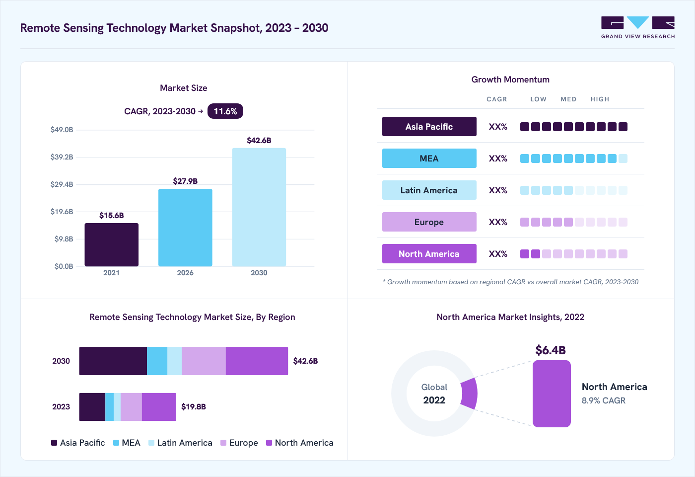
Market Size, 2022
$17.5BMarket Estimate, 2026
$27.9BMarket Forecast, 2030
$42.6BCAGR, 2023–2030
11.6%Remote Sensing Technology Market Summary
The global remote sensing technology market size was valued at USD 17.5 billion in 2022 and is projected to grow from USD 27.9 billion in 2026 to USD 42.6 billion by 2030, at a CAGR of 11.6% from 2023 to 2030. North America dominated the market, accounting for a revenue share of 36.3% in 2022. Remote sensing technology is used to acquire information about the earth's surface and analyze its physical characteristics.
Key Market Trends & Insights
- Asia Pacific is expected to grow at the fastest CAGR of 14.5% during the forecast period.
- By technology, the passive remote sensing segment held the largest market share of 58.9% in 2022.
- By application, disaster management is anticipated to register the fastest CAGR of 16.4% from 2023 to 2030.
Market Size & Forecast
- 2022 Market Size: USD 17.5 Billion
- 2030 Projected Market Size: USD 42.6 Billion
- CAGR (2023-2030): 11.6%
- North America: Largest market in 2022
It uses reflected and emitted light from aircraft and satellites without the need for physical contact with the surface area under study. The market is mainly driven by numerous space agencies' increasing number of earth observation projects. For instance, the Indian Space Research Organization (ISRO) has thirteen earth observation satellites and plans to launch ten earth observation satellites during 2020-2021. The outbreak of the COVID-19 pandemic led numerous countries to impose strict lockdown measures. This led to an increase in the adoption of remote sensing technology to monitor and curb the spread of viruses and document environmental changes.

For instance, in June 2020, NASA, the Japan Aerospace Exploration Agency (JAXA), and the European Space Agency (ESA) partnered to create a new earth observation dashboard that documents changes in the environment and human lifestyle due to the COVID-19 virus. The dashboard integrates numerous satellite records to allow user-friendly tracking of changes in climate, agriculture, and economic activity. The increasing adoption of smart city projects is paving the way for market growth. The technology helps authorities in zoning and urban planning, infrastructure modeling, and security and law enforcement planning. Numerous countries focus on developing infrastructure and invest heavily in their smart city projects. This is expected to propel the market growth over the forecast period.
The need for high initial investments in manufacturing numerous components is impeding the growth of the remote sensing technology market. The market players need to manufacture components and encrypt data content that meets the standards set by regulatory organizations. This limits the growth possibilities for companies in the market. However, increasing adoption in research and exploration applications is expected to drive the market in the next seven years.
The growing adoption of Internet of Things (IoT) technology in agriculture is anticipated to drive market growth over the forecast period. IoT in agriculture uses remote sensors, drones, robots, and computer imaging to monitor crops and provide data to farmers for effective farm management. IoT-based remote sensing employs sensors placed on farms and collects data transmitted for analysis. Farmers can monitor the crops from an analytical dashboard and act accordingly based on the insights.
Technology Insights
The passive remote sensing segment held the largest market share of 58.9% in 2022and is expected to grow at the fastest CAGR of 12.8% during the forecast period. Passive remote sensing technology measures the reflected sunlight from the earth’s surface to monitor and analyze surface characteristics. The technology provides high-quality satellite images and hence is widely used for earth various observation applications.
The active remote sensing segment is anticipated to witness significant growth with a CAGR of 9.5% over the forecast period. This technology emits its own light to monitor and analyze the surface characteristics. The active remote sensing technology overcomes the drawbacks of passive remote sensing, which cannot be used to analyze surface characteristics at night. Active remote sensing technology is widely used for measuring forest structure, ice, and sea surface topography, among others.
Application Insights
The military and intelligence segment held the largest market share of 31.7% in 2022. This is attributable to the growing adoption of technology by developed countries to monitor and prevent criminal and destructive activities. Moreover, countries such as China and Russia are focusing on using satellite images for defense applications. These factors are expected to boost demand over the forecast period.
The disaster management segment is anticipated to register the fastest CAGR of 16.4% during the forecast period. The technology provides vital information related to natural disasters such as storms and volcano eruptions. The availability of continuously updated data helps authorities make better decisions related to evacuations and actions to be taken post the disaster. The application segment also comprises agriculture and living resources, infrastructure, weather, and others.
Platform Insights
The aerial systems segment held the largest market share of 70.7% in 2022and is expected to grow at the fastest CAGR of 12.7% during the forecast period. This is attributable to the increasing usage of a drone or Unmanned Aerial vehicles (UAVs) in aerial mapping. The usage of drones in surveying fields reduces costs and helps gather data at a faster rate. Moreover, surface mapping over these devices provides data of high accuracy and survey areas that cannot be accessed over satellites.

The satellite segment is expected to witness significant growth with a CAGR of 8.3% during the forecast period. This is attributable to the increasing number of earth observation projects by major space agencies such as NASA. Additionally, increasing the adoption of satellite-based images for weather forecasting is another factor expected to propel the demand over the forecast period. Meteorological satellites can estimate the winds near the sea surface from space, which is useful for locating and tracking cyclones.
Regional Insights
North America held the largest market share of 36.3% in 2022. This share is attributable to the presence of key market players such as Lockheed Martin Corporation; Esri; General Dynamics Mission Systems, Inc.; and Raytheon Technologies Corporation. The adoption of remote sensing technology in precision farming applications is anticipated to fuel the market growth during the forecast period. The technology provides water resource managers tools to mitigate the impact of dry spells and drought and match crops' irrigation needs.

Asia Pacific is expected to grow at the fastest CAGR of 14.5% during the forecast period. This is attributable to the increasing adoption of earth observation for infrastructure development applications. Countries such as China, Japan, Australia, and India are considered the region’s most lucrative markets for remote sensing technology providers. Government initiatives for urban infrastructure development such as India’s Smart City Mission are also expected to augment the regional market growth.
Key Companies & Market Share Insights
The key market players are opting for inorganic growth strategies such as acquisitions and mergers to enhance their market share. For instance, in January 2019, UrtheCast announced the acquisition of Geosys Technology Holding LLC for USD 20 million. Through this acquisition, the former company aims to enhance its market position in geo-analytics solutions for agriculture. The market players are also focusing on gaining contracts from scientific and defense agencies for various projects and augmenting their market share. For instance, in February 2019, General Dynamics Information Technology, Inc. announced it received contracts from the National Geospatial-Intelligence Agency (NGA), an agency of the U.S. Defense Department for providing earth observation technologies. Moreover, companies are focusing on investing heavily in their research and development activities to develop technologically advanced products.
Key Remote Sensing Technology Companies:
- Maxar Technologies
- Esri.
- General Dynamics Mission Systems, Inc.
- Hexagon AB
- Lockheed Martin Corporation.
- Orbital Insight
- Planet Labs PBC.
Recent Developments
-
In July 2023, Hexagon, a company in digital reality solutions, acquired HARD-LINE, a Canada-based automation company specializing in mining operations. This acquisition strengthened Hexagon's position in the mining industry and helped the company offer a more comprehensive suite of solutions for mine operators.
-
In January 2023, Lockheed Martin Corporation launched Lockheed Martin LM 400, an adaptable, medium-sized satellite customizable for military, civil, or commercial purposes. LM 400 spacecraft bus design allows platforms to support remote communications, radar, sensing, imaging, and persistent surveillance.
-
In December 2022, OSASI Technos Inc. and Hexagon AB collaborated to offer futuristic disaster management and monitoring solutions. It helps governments to identify, predict, and simulate approaching crises using wide-area remote monitoring systems with 3D visualization capabilities.
-
In November 2022, China launched the Yaogan-34 remote-sensing satellite. Equipped with high-resolution cameras the satellite was launched to conduct land surveys and disaster prevention.
Remote Sensing Technology Market Report Scope
Report Attribute
Details
Market size in 2022
USD 17.5 billion
Estimated market size in 2026
USD 27.9 billion
Projected market size by 2030
USD 42.6 billion
Growth rate
CAGR of 11.6% from 2023 to 2030
Base year for estimation
2022
Historical data
2017 - 2021
Forecast period
2023 - 2030
Report updated
November 2023
Quantitative units
Revenue in USD million and CAGR from 2023 to 2030
Report coverage
Revenue forecast, company ranking, competitive landscape, growth factors, and trends
Segments covered
Technology, application, platform, region
Regional scope
North America; Europe; Asia Pacific; Latin America; MEA
Country scope
U.S.; Canada; U.K.; Germany; France; China; Japan; India; Australia; South Korea; Brazil; Mexico; Saudi Arabia; South Africa; UAE
Key companies profiled
Maxar Technologies; Esri.; General Dynamics Mission Systems, Inc.; Hexagon AB; Lockheed Martin Corporation.; Orbital Insight; Planet Labs PBC.
Customization scope
Free report customization (equivalent up to 8 analyst’s working days) with purchase. Addition or alteration to country, regional & segment scope
Pricing and purchase options
Avail customized purchase options to meet your exact research needs. Explore purchase options
Global Remote Sensing Technology Market Report Segmentation
This report forecasts revenue growth at global, regional, and country levels and provides an analysis of the latest industry trends in each of the sub-segments from 2017 to 2030. For this study, Grand View Research has segmented the global remote sensing technology market based on technology, application, platform, and region:

-
Technology Outlook (Revenue, USD Million, 2017 - 2030)
-
Active Sensing
-
Passive Sensing
-
-
Application Outlook (Revenue, USD Million, 2017 - 2030)
-
Agriculture & Living Resources
-
Military & Intelligence
-
Disaster Management
-
Infrastructure
-
Weather
-
Others
-
-
Platform Outlook (Revenue, USD Million, 2017 - 2030)
-
Satellite
-
Aerial Systems
-
-
Regional Outlook (Revenue, USD Million, 2017 - 2030)
-
North America
-
U.S.
-
Canada
-
-
Europe
-
U.K.
-
Germany
-
France
-
-
Asia Pacific
-
China
-
Japan
-
India
-
Australia
-
South Korea
-
-
Latin America
-
Brazil
-
Mexico
-
-
Middle East and Africa
-
Saudi Arabia
-
South Africa
-
UAE
-
-
Frequently Asked Questions About This Report
The global remote sensing technology market is expected to grow at a compound annual growth rate of 11.6% from 2023 to 2030 to reach USD 42.64 billion by 2030.
North America dominated the remote sensing technology market with a share of 36.3% in 2022. The rising adoption of remote sensing technology in precision farming applications is anticipated to fuel market growth during the forecast period.
Some key players operating in the remote sensing technology market include Maxar Technologies; Esri.; General Dynamics Mission; Systems, Inc.; Hexagon AB; Lockheed Martin Corporation.; Orbital Insight; and Planet Labs PBC.; among others.
The global remote sensing technology market size was estimated at USD 17.53 billion in 2022 and is expected to reach USD 19.82 billion in 2023.
The growing adoption of Internet of Things (IoT) technology in agriculture is anticipated to drive market growth over the forecast period. IoT in agriculture uses remote sensors, drones, robots, and computer imaging to monitor crops and provide data to farmers for effective farm management.
About the Author(s)
Communication Services Research Team
Technology · Communication ServicesThis report was authored by the communication services research team at Grand View Research - comprising two research analysts, one senior research analyst, and one industry expert - with specialized expertise in the communication services segment of the technology industry. All findings are based on proprietary technology databases, executive interviews, and regulatory analysis, subject to internal peer review prior to publication.
Last Updated:
Speak to Analyst

Need a Tailored Report?
Customize this report to your needs — add regions, segments, or data points, with 20% free customization.
Or view our licence options:

ISO 9001:2015 & 27001:2022 Certified
We are GDPR and CCPA compliant! Your transaction & personal information is safe and secure. For more details, please read our privacy policy.