
- Home
- »
- Next Generation Technologies
- »
-
Agricultural Mapping Services Market Size Report 2026-2033GVR Report cover
![Agricultural Mapping Services Market (2026 - 2033)Report]()
Agricultural Mapping Services Market (2026 - 2033)
Size, Share & Trends Analysis Report By Type (Field Mapping, Soil Mapping), By Technology, By Deployment (Cloud, On-premise), By Application, By End-use (Farmers, Agribusinesses, Research Institutions), By Region, And Segment Forecasts
Market Size, 2025
$5.7BMarket Estimate, 2026
$6.0BMarket Forecast, 2033
$9.2BCAGR, 2026–2033
6.4%Agricultural Mapping Services Market Summary
The global agricultural mapping services market size was valued at USD 5.7 billion in 2025 and is projected to grow from USD 6.0 billion in 2026 to USD 9.2 billion by 2033, at a CAGR of 6.4% from 2026 to 2033. North America dominated the market, accounting for a revenue share of 31.8% in 2025. The increasing use of remote sensing for crop health assessment is driving growth in the agricultural mapping services industry.

Key Market Trends & Insights
- By type: Field mapping held the largest revenue share of 33.5% in 2025.
- By technology: Satellite-based mapping held the largest revenue share of 39.6% in 2025.
- By deployment: Cloud segment held the largest revenue share of 65.7% in 2025.
- By end-use: Farmers segment held the largest revenue share of 42.0% in 2025.
Regional Highlights
- Largest regional market: North America (31.8% revenue share, 2025)
- Fastest-growing regional market: Asia Pacific (highest CAGR, 2026-2033)
- By country: The U.S. held the largest market share in 2025.
Market Size & Forecast
- Market size in 2025: USD 5.7 Billion
- Estimated market size in 2026: USD 6.0 Billion
- Projected market size by 2033: USD 9.2 Billion
- CAGR (2026-2033): 6.4%
The increasing adoption of precision agriculture is driving market growth in the agricultural mapping services market as producers seek highly accurate field information to optimize crop production and resource utilization. Modern farming increasingly relies on detailed spatial intelligence to identify variations in soil characteristics, crop vigor, moisture conditions, elevation, and field boundaries before making management decisions. Agricultural mapping services transform raw geographic information into practical insights that enable producers to apply inputs more efficiently across individual field zones. A better understanding of field variability improves operational planning while supporting higher agricultural productivity. The growing transition toward precision-based farming continues to strengthen demand for professional agricultural mapping services.
The expanding use of satellite imagery, unmanned aerial systems, and advanced remote sensing technologies is propelling market growth by providing farmers with increasingly detailed and frequently updated field intelligence throughout the production cycle. Agricultural mapping services integrate these technologies to generate comprehensive visual representations of crop development, vegetation health, drainage conditions, planting progress, and land utilization patterns. High-resolution mapping improves decision-making and allows producers to detect field variations that may not be visible during traditional field inspections. Better visibility enhances operational efficiency across planting, irrigation, fertilization, and harvesting activities. Continuous improvements in geospatial technologies reinforce long-term market expansion.
The growing emphasis on efficient resource management contributes to market growth as agricultural producers seek accurate mapping solutions that improve the allocation of water, fertilizers, crop protection products, labor, machinery, and planting materials. Field-level mapping enables producers to identify areas that require different management strategies, rather than treating entire farms uniformly. More targeted resource allocation improves productivity while reducing unnecessary operational expenses across diverse agricultural environments. Accurate spatial information strengthens both economic and environmental sustainability within modern farming systems. The increasing importance of optimized resource utilization supports expanding adoption of agricultural mapping services.
Market Dynamics
The agricultural mapping services market is experiencing sustained growth as farmers, agribusinesses, and agricultural service providers increasingly rely on spatial data to improve field planning, crop management, and operational efficiency. Services such as boundary mapping, soil variability analysis, crop health mapping, yield mapping, topographic surveying, and drainage assessment are enabling more precise management of agricultural land and supporting informed decision-making throughout the crop cycle. The growing adoption of satellite imagery, drones, GPS technologies, and geographic information systems (GIS) is enhancing the accuracy and accessibility of mapping services across farms of all sizes. In addition, the increasing implementation of precision agriculture practices and the need to optimize land utilization are driving demand for professional agricultural mapping solutions.
The rising adoption of precision agriculture practices is driving market growth in the agricultural mapping services market as producers increasingly require highly accurate spatial information to support field-specific crop management decisions. Precision farming relies on understanding variability within individual fields rather than treating entire farms as uniform production areas, making detailed mapping an essential operational requirement. Agricultural mapping services generate location-specific information on soil characteristics, crop health, field boundaries, elevation, moisture distribution, and productivity zones that guide more informed agronomic decisions. This level of precision enables producers to optimize every stage of the cultivation cycle while improving overall operational efficiency. The expanding adoption of precision farming methodologies continues to increase demand for advanced mapping services.
The high costs of advanced mapping technologies and services act as a major restraint in the agricultural mapping services market by limiting adoption among producers with constrained capital budgets. Modern mapping solutions frequently combine high-resolution satellite imagery, drone surveys, multispectral sensors, LiDAR systems, geographic information systems, advanced analytics software, and professional interpretation services, resulting in substantial implementation costs. Many agricultural businesses carefully evaluate technology investments according to expected operational returns and seasonal profitability before committing to advanced mapping programs. When acquisition and service costs exceed immediate financial expectations, producers often postpone adoption or continue relying on conventional field assessment methods. This hesitation to invest moderates the pace of market expansion.
The increasing adoption of 3D terrain and topographic mapping is creating substantial opportunities in the agricultural mapping services market by enabling farmers and agricultural planners to gain a more detailed understanding of land characteristics. Traditional two-dimensional mapping provides valuable spatial information, but 3D terrain analysis offers additional insights into elevation changes, slope variations, drainage pathways, and surface contours that directly influence crop performance. This enhanced land intelligence allows producers to make more accurate decisions regarding field preparation, crop placement, irrigation design, and soil conservation practices. A better understanding of terrain conditions improves the efficiency of resource allocation across agricultural operations. The growing reliance on three-dimensional spatial analysis contributes to market growth by expanding the value proposition of advanced mapping services.
Analyst Perspective
The agricultural mapping services market is evolving from a standalone surveying function into a strategic information service that underpins precision agriculture and digital farm management. The competitive landscape is increasingly influenced by the ability to deliver high-resolution, timely, and actionable geospatial intelligence rather than simply generating maps. Service providers that can combine satellite imagery, drone-based data collection, GIS expertise, and agronomic interpretation into practical recommendations will be better positioned to establish long-term relationships with farmers and agribusinesses. As agricultural operations become increasingly data-centric, mapping services are expected to play a critical role in supporting variable-rate applications, field optimization, investment planning, and sustainable land management across the farming lifecycle.
Type Insights
The field mapping segment dominated the agricultural mapping services market, accounting for the largest share of 33.5% in 2025. The increasing adoption of digital field management systems is creating substantial opportunities for the field mapping segment by making accurate field boundary information a fundamental requirement for modern farming operations. Farmers are increasingly replacing manual recordkeeping with digital farm management platforms that rely on precise field maps to plan cultivation activities, track crop performance, and manage operational resources. Accurate field mapping provides the geographic foundation needed to organize field-specific production data throughout the growing season. Better digital organization improves decision-making while increasing operational transparency across agricultural enterprises. The continued modernization of farm management contributes to market growth by expanding demand for professional field mapping services.
The crop health mapping segment is anticipated to grow at the fastest CAGR during the forecast period. The increasing demand for proactive crop management is creating significant opportunities for the crop health mapping segment by enabling producers to identify plant stress before visible symptoms become widespread. Modern crop health mapping uses multispectral and geospatial analysis to reveal subtle variations in vegetation condition that cannot be detected through conventional field inspections alone. Early identification of differences in crop performance allows farmers to implement timely agronomic interventions that improve productivity and reduce avoidable yield losses. Faster decision-making strengthens operational efficiency throughout the growing season while supporting higher-quality crop production. The growing emphasis on preventive farm management contributes to market growth by expanding demand for crop health mapping services.
Technology Insights
The satellite-based mapping segment led the agricultural mapping services industry, accounting for the largest share of 39.6% in 2025. The increasing importance of climate adaptation planning is propelling market growth by encouraging producers to utilize satellite-based mapping for evaluating changing environmental conditions affecting agricultural productivity. Satellite imagery provides long-term visibility into vegetation patterns, moisture distribution, drought development, flooding impacts, and land use changes across agricultural landscapes. These insights allow farmers to develop more resilient production strategies that respond effectively to evolving climatic conditions while protecting long-term farm productivity. Better environmental intelligence strengthens strategic agricultural planning across diverse farming regions. Climate-focused agricultural management continues expanding opportunities for satellite mapping solutions.
The LiDAR-based mapping segment is expected to grow at the fastest CAGR from 2026 to 2033. The increasing integration of LiDAR technology with autonomous agricultural equipment is driving market growth as intelligent machinery requires highly accurate terrain information to navigate safely and efficiently across complex farming environments. LiDAR-generated digital terrain models provide detailed geographic references that improve equipment routing, obstacle identification, field navigation, and operational consistency. More precise terrain data enhances the performance of automated tractors, robotic agricultural equipment, and precision farming systems operating across uneven landscapes. Improved navigation accuracy increases operational efficiency while reducing machinery-related risks. The continued evolution of autonomous farming technologies creates attractive opportunities within the LiDAR-based mapping segment.
Deployment Insights
The cloud segment dominated the agricultural mapping services market with revenue share of 65.7% in 2025. The rising integration of cloud computing with precision agriculture technologies is driving market growth by creating unified digital ecosystems that connect mapping services with crop monitoring, machinery guidance, irrigation management, weather intelligence, farm management software, and predictive analytics platforms. Cloud deployment enables seamless information exchange between these technologies, allowing producers to make more informed operational decisions using consolidated agricultural intelligence. Better interoperability strengthens the overall value of mapping services while improving workflow efficiency across farming operations. Integrated digital agriculture environments encourage broader technology adoption throughout the industry. This expanding connectivity supports long-term growth opportunities.
The on-premise segment is expected to register a significant CAGR from 2026 to 2033. The rising need for integration with legacy agricultural systems contributes to market growth by allowing organizations to connect modern mapping technologies with existing operational software already deployed within internal infrastructure. Many commercial agricultural enterprises continue utilizing established enterprise resource planning platforms, inventory systems, machinery management applications, and production databases developed over many years. On-premise mapping solutions simplify integration with these internal systems while reducing migration complexity. Better interoperability improves operational consistency across multiple business functions. Legacy system modernization creates sustained opportunities within the on-premise segment.
Application Insights
The precision farming segment dominated the agricultural mapping services industry, accounting for the largest share of 38.0% in 2025. The increasing modernization of commercial agricultural enterprises contributes to market growth, as producers invest in precision farming technologies that improve productivity across expanding operations. Precision farming requires accurate geographic information to standardize management practices across numerous fields while accommodating differences in soil conditions, topography, crop performance, and environmental characteristics. Agricultural mapping services simplify this complexity through comprehensive digital field intelligence supporting consistent operational execution. Better management scalability improves efficiency throughout large agricultural businesses. Enterprise modernization continues to strengthen market opportunities for mapping providers.
The variable rate application segment is expected to grow at a significant CAGR from 2026 to 2033. The increasing emphasis on soil-specific crop management is driving market growth by encouraging producers to adopt variable-rate application strategies that account for differences in soil fertility, organic matter, moisture retention, and productivity across individual fields. Agricultural mapping services identify these spatial variations through geospatial analysis and translate them into application plans that support more accurate agronomic management. Better alignment between field conditions and agricultural inputs improves crop development while minimizing unnecessary application in low-response areas. More efficient crop management enhances both economic performance and environmental sustainability. The expansion of site-specific farming continues to increase demand for mapping services.
End-use Insights
The farmers segment led the agricultural mapping services market, accounting for the largest market share of 42.0% in 2025. The increasing diversification of crop production is driving market growth, as farmers cultivate multiple crop varieties that require different management approaches within the same agricultural operation. Agricultural mapping services enable producers to organize field-specific information that reflects varying crop requirements, production schedules, and agronomic conditions across different cultivation zones. Better geographic organization improves planning efficiency while simplifying management of increasingly diverse farming systems. More accurate operational coordination enhances productivity across mixed agricultural enterprises. Diversified farming practices reinforce demand for advanced mapping services.
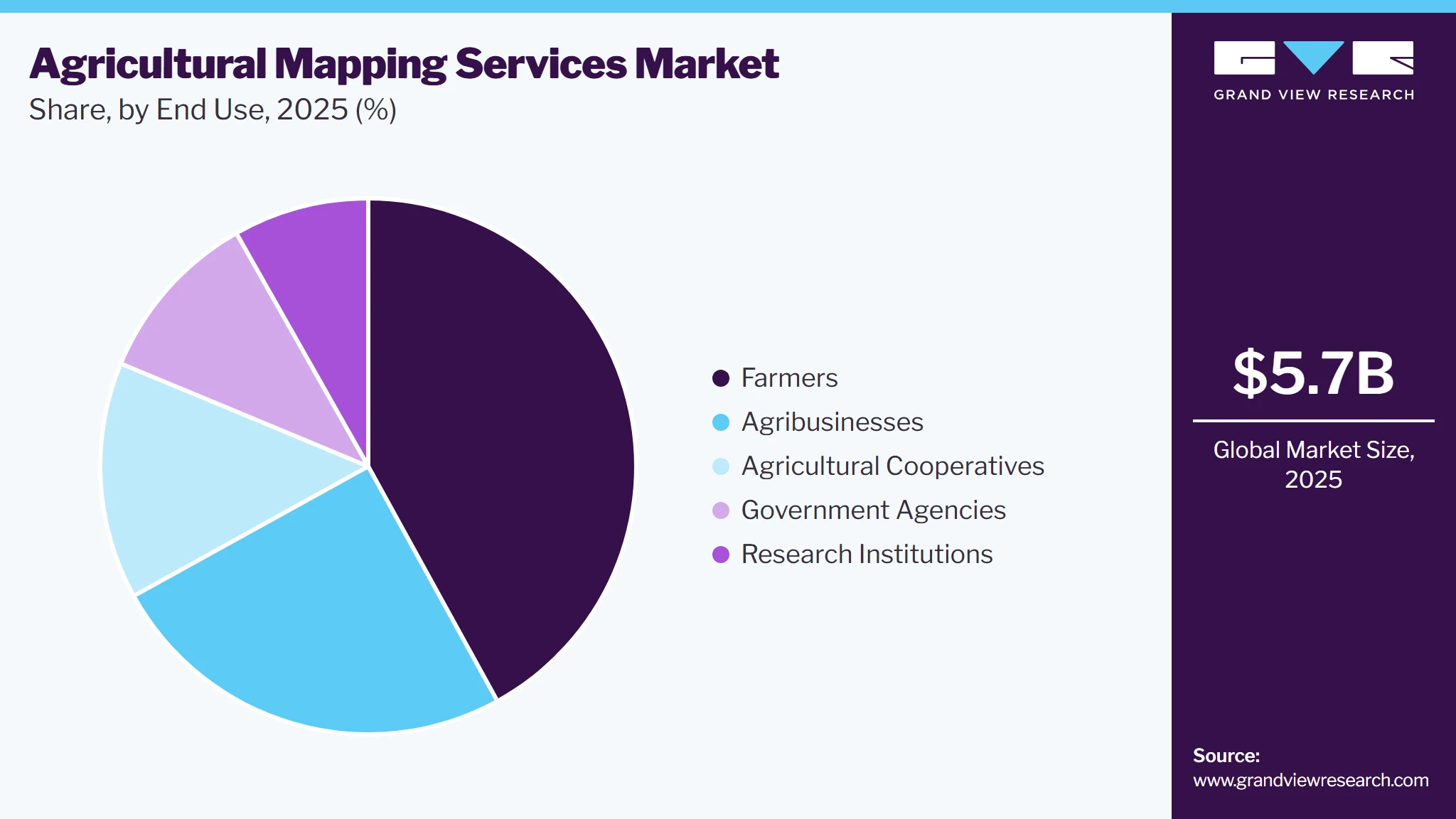
The agricultural cooperatives segment is anticipated to register the fastest CAGR during the forecast period. The increasing need for centralized farm coordination is driving market growth within the agricultural cooperatives segment, as cooperatives manage production activities across numerous member farms with varying crop types and field conditions. Agricultural mapping services enable cooperatives to create standardized geographic records that improve planning, monitoring, and operational coordination across large agricultural networks. Shared mapping platforms allow cooperative managers to evaluate field performance more efficiently while maintaining consistent agronomic guidance for participating members. Better visibility across multiple farms strengthens production planning and resource management throughout the growing season. The expanding role of coordinated agricultural management contributes to market growth by increasing the adoption of mapping services among cooperatives.
Regional Insights
North America dominated the agricultural mapping services market, accounting for 31.8% revenue in 2025. The growing integration of drone technologies into agricultural operations is driving market growth as producers increasingly use aerial data collection to improve field monitoring and production management. Agricultural mapping services transform drone imagery into actionable geographic intelligence that supports crop evaluation, infrastructure planning, field inspection, and precision farming activities. More frequent aerial observations improve operational responsiveness while reducing dependence on manual field inspections across large agricultural properties. Better visibility strengthens production management throughout multiple crop growth stages. Expanding drone utilization reinforces growth opportunities for mapping service providers.

U.S. Agricultural Mapping Services Market Trends
The U.S. agricultural mapping services industry is projected to grow significantly during the forecast period. The rising integration of automated agricultural machinery is driving market growth by increasing the requirement for highly accurate digital field maps supporting advanced machine operations. Autonomous tractors, intelligent sprayers, precision seeders, harvesting equipment, and guidance technologies rely on accurate geographic information to perform field activities with greater consistency and precision. Agricultural mapping services generate detailed operational maps that improve navigation, application accuracy, and workflow coordination throughout farming operations. Better machine performance enhances productivity while reducing operational variability across cultivated land.
Asia Pacific Agricultural Mapping Services Trends
The agricultural mapping services industry in Asia Pacific is expected to grow at the fastest CAGR from 2026 to 2033. The increasing use of remote sensing technologies contributes to market growth by enabling agricultural producers to monitor large farming areas more efficiently than with traditional field inspections. Satellite imagery, drone surveys, and aerial monitoring increasingly generate valuable agricultural information that becomes more useful when processed through professional mapping services. Agricultural mapping transforms these datasets into actionable geographic intelligence supporting crop monitoring, production planning, and operational management. Better remote visibility allows producers to respond more quickly to changing field conditions throughout the growing season. The broader use of remote sensing significantly expands mapping market opportunities.
The agricultural mapping services market in China is projected to grow significantly during the forecast period. The growing focus on efficient land utilization is driving market growth as producers seek detailed geographic intelligence to improve productivity on existing cultivated land. Agricultural mapping services enable farmers to evaluate terrain conditions, field variability, crop performance, and land characteristics that influence agricultural output across different production zones. More efficient land management improves operational profitability while supporting sustainable agricultural development. The growing emphasis on maximizing agricultural productivity reinforces the adoption of mapping services.
The India agricultural mapping services market is projected to grow significantly during the forecast period. The increasing demand for organized farm planning is propelling market growth as producers seek structured approaches for managing seasonal agricultural operations across multiple fields and crop varieties. Agricultural mapping services help organize field information through digital records, simplifying cultivation planning, crop scheduling, land-use analysis, and long-term production management. Better geographic organization reduces operational complexity while improving coordination across farming activities throughout the year. Growing interest in organized agricultural management continues to expand mapping service adoption.
Europe Agricultural Mapping Services Market Trends
The agricultural mapping services industry in Europe is anticipated to grow steadily from 2026 to 2033. The growing emphasis on sustainable agricultural production is propelling market growth as European producers increasingly prioritize efficient resource utilization while maintaining long-term land productivity. Agricultural mapping services enable farmers to evaluate spatial differences in soil conditions, crop performance, moisture distribution, and terrain characteristics that influence sustainable farm management practices. Better geographic intelligence supports more precise allocation of fertilizers, irrigation resources, and crop protection measures while reducing unnecessary input usage. Improved environmental management strengthens both agricultural productivity and operational efficiency across farming enterprises.
The agricultural mapping services market in the UK is expected to grow significantly during the forecast period. The growing use of geospatial intelligence for infrastructure planning is driving market growth as agricultural businesses increasingly utilize mapping services when designing drainage systems, irrigation layouts, farm roads, storage facilities, and operational improvements. Agricultural mapping provides detailed terrain analysis that improves engineering accuracy while reducing planning uncertainty for agricultural development projects. Better infrastructure planning enhances operational efficiency while supporting future production expansion across farming enterprises. Geographic information simplifies investment planning while improving long-term farm performance.
The Germany agricultural mapping services market is expected to grow significantly during the forecast period. The growing use of geospatial intelligence for infrastructure planning is driving market growth as agricultural businesses increasingly utilize mapping services when designing drainage systems, irrigation layouts, farm roads, storage facilities, and operational improvements. Agricultural mapping provides detailed terrain analysis that improves engineering accuracy while reducing planning uncertainty for agricultural development projects. Better infrastructure planning enhances operational efficiency while supporting future production expansion across farming enterprises. Geographic information simplifies investment planning while improving long-term farm performance.
Key Agricultural Mapping Services Company Insights
Some prominent players in the agricultural mapping services market include EarthOptics and Esri.
-
Esri is a software company specializing in geographic information systems (GIS), geospatial analytics, and location intelligence. Esri focuses on transforming geographic data into actionable intelligence through cloud-based GIS platforms, spatial analytics, artificial intelligence, and real-time mapping technologies. Its software enables users to visualize, analyze, and manage spatial information for improved planning, resource management, and operational decision-making.
-
EarthOptics is an agricultural technology company specializing in soil intelligence, digital agriculture, and geospatial analytics. The company focuses on providing farmers, agribusinesses, and land managers with detailed insights into soil health and field conditions by combining advanced sensing technologies, machine learning, geophysical measurements, and remote data analytics. Its technology platform integrates multiple data sources to generate comprehensive soil intelligence, enabling producers to optimize field management while improving long-term soil performance.
Key Agricultural Mapping Services Companies:
The following key companies have been profiled for this study of the agricultural mapping services market.
-
AS Communications (UK) Ltd.
-
EarthOptics
-
Esri
-
Grasstec Group
-
Land Solution Australia
-
Pix4D SA
-
SATPALDA
-
Syngenta AG
-
Terra Drone Corp.
-
The Sanborn Map Company, Inc.
Competitive Benchmarking
Operating Strategies
Competitive Edge
Weakness
Mature Players: Esri; Grasstec Group; SATPALDA
- Mature players focus on integrating satellite imagery, GIS, UAV mapping, and geospatial analytics with precision farming platforms to support field planning, crop monitoring, and resource optimization.
- They expand their market presence through long-term partnerships with agricultural enterprises, government agencies, and input suppliers while continuously improving mapping accuracy and interoperability with digital farming ecosystems.
- These companies benefit from extensive geospatial expertise, strong agricultural technology ecosystems, and broad customer networks, enabling large-scale deployment across diverse farming regions.
- Their ability to integrate mapping services with precision farming equipment, agronomic analytics, and farm management software provides greater operational efficiency and long-term customer value.
- Developing and maintaining high-resolution mapping solutions requires continuous investment in geospatial technologies, data acquisition, and software innovation.
- Dependence on high-quality imagery, regional data availability, and seasonal agricultural demand can also influence service scalability and operating costs.
Emerging Players: AS Communications (UK) Ltd.; EarthOptics; Land Solution Australia
- Emerging players focus on AI-enabled field intelligence, drone-based mapping, and cloud-native analytics to deliver rapid agronomic insights and support sustainable farming practices.
- They emphasize scalable subscription models and automated image analysis to deliver actionable recommendations with minimal turnaround time.
- Their specialized technologies provide highly detailed field intelligence, quicker data processing, and flexible service models that support precision agriculture without requiring extensive on-farm infrastructure.
- Strong innovation in AI, remote sensing, and predictive agronomic analytics enables them to address evolving requirements for sustainable and data-driven farming.
- Emerging providers often have limited geographic coverage, smaller customer bases, and lower operational scale than established competitors.
- Expanding data acquisition capabilities, building long-term customer trust, and competing with integrated agricultural technology platforms remain significant challenges for broader market adoption.
Recent Developments
-
In November 2026, Pix4D SA partnered with Vantor to make Vantor’s high-resolution satellite imagery directly accessible to all PIX4Dfields users, strengthening precision agriculture capabilities. PIX4Dfields combines high-resolution drone and satellite imagery with advanced AI and offline processing to deliver features such as automated weed detection, obstacle mapping, and the generation of variable-rate and spot-spraying prescription maps. By enabling sub-field level analysis and seamless export of prescription maps to agricultural machinery, the solution helps farmers optimize input usage and make more informed, data-driven crop management decisions.
-
In April 2025, Syngenta expanded its multi-year strategic partnership with Planet Labs to strengthen digital agriculture capabilities through enhanced satellite-based crop monitoring. The partnership further enhances the existing integration of Planet’s satellite data into the Cropwise platform, providing growers with an advanced precision agriculture solution for informed decision-making. Through this agreement, Cropwise users gain access to Planet’s Dove satellite constellation, which delivers daily imagery with 3-meter resolution. This frequent, high-quality imaging provides continuous field visibility and deeper agronomic insights, even in regions with persistent cloud cover.
-
In January 2025, Grasstec Group was appointed as the official distributor of PTx Trimble products across England and Wales, strengthening access to advanced precision agriculture technologies for farmers throughout the western UK. Through this partnership, the company will deliver a comprehensive portfolio of PTx Trimble Ag solutions, including advanced GPS-enabled farm planning and precision layout design to improve operational efficiency, labor productivity, and livestock movement. In addition, Grasstec Group continues to support the agricultural sector by sourcing high-quality dairy livestock for farm-to-farm sales across Ireland, the UK, and Europe.
Agricultural Mapping Services Market Report Scope
Report Attribute
Details
Market size in 2025
USD 5.7 billion
Estimated market size in 2026
USD 6.0 billion
Projected market size by 2033
USD 9.2 billion
Growth rate
CAGR of 6.4% from 2026 to 2033
Actual data
2021 - 2025
Forecast period
2026 - 2033
Quantitative units
Revenue in USD million and CAGR from 2026 to 2033
Report coverage
Revenue forecast, company share, competitive landscape, growth factors, and trends
Segments covered
Type, technology, deployment, application, end-use, region
Regional scope
North America; Europe; Asia Pacific; Latin America; MEA
Country scope
U.S.; Canada; Mexico; UK; Germany; France; China; India; Japan; Australia; South Korea; Brazil; UAE; Saudi Arabia; South Africa
Key companies profiled
AS Communications (UK) Ltd.; EarthOptics; Esri; Grasstec Group; Land Solution Australia; Pix4D SA; SATPALDA; Syngenta AG; Terra Drone Corp.; The Sanborn Map Company, Inc.
Customization scope
Free report customization (equivalent to 8 analysts working days) with purchase. Addition or alteration to country, regional & segment scope.
Pricing and purchase options
Avail customized purchase options to meet your exact research needs. Explore purchase options
Global Agricultural Mapping Services Market Report Segmentation
This report forecasts revenue growth at global, regional, and country levels and provides an analysis of the latest industry trends in each of the sub-segments from 2021 to 2033. For this study, Grand View Research has segmented the agricultural mapping services market report based on type, technology, deployment, application, end-use, and region:
-
Type Outlook (Revenue, USD Million, 2021 - 2033)
-
Field Mapping
-
Soil Mapping
-
Crop Health Mapping
- Yield Mapping
-
Others
-
-
Technology Outlook (Revenue, USD Million, 2021 - 2033)
-
Satellite-Based Mapping
-
Drone (UAV)-Based Mapping
-
LiDAR-Based Mapping
-
GPS/GNSS-Based Mapping
-
-
Deployment Outlook (Revenue, USD Million, 2021 - 2033)
-
Cloud
-
On-premise
-
-
Application Outlook (Revenue, USD Million, 2021 - 2033)
-
Precision Farming
-
Variable Rate Application
-
Farm Asset Management
-
Land Use Planning
-
Others
-
-
End-use Outlook (Revenue, USD Million, 2021 - 2033)
-
Farmers
-
Agribusinesses
-
Agricultural Cooperatives
-
Government Agencies
-
Research Institutions
-
-
Regional Outlook (Revenue, USD Million, 2021 - 2033)
-
North America
-
U.S.
-
Canada
-
Mexico
-
-
Europe
-
Germany
-
UK
-
France
-
-
Asia Pacific
-
China
-
India
-
Japan
-
South Korea
-
Australia
-
-
Latin America
-
Brazil
-
-
Middle East & Africa
-
UAE
-
Saudi Arabia
-
South Africa
-
-
Research Methodology
The agricultural mapping services market figures in this report are based on a proven research process that combines executive interviews with secondary research from proprietary databases, company filings, and recognized regulatory and institutional sources. Market size is built through value-chain sizing-reconciling supply-side and demand-side estimates-and triangulated with bottom-up and top-down approaches. Every estimate passes multiple levels of expert validation before publication, with each agricultural mapping services segment quantified using the revenue-capture definitions in the table below.
Segment Definition
Segment - Type
Revenue capture definition
Field Mapping
The largest mapping service segment, capturing value through detailed digital field boundary creation, topographical surveys, and geospatial visualization that support farm planning and machinery guidance. Service providers benefit from recurring demand as farms continuously update field records for seasonal crop planning and operational optimization.
Soil Mapping
Commercial demand is driven by the need to assess soil composition, fertility, nutrient variability, texture, and moisture distribution across agricultural land. These services enable growers to optimize fertilizer application, improve soil productivity, and support long-term sustainable land management.
Crop Health Mapping
Market value is created through multispectral and hyperspectral imagery that identifies crop stress, pest infestations, nutrient deficiencies, and disease outbreaks before visible symptoms appear. Increasing adoption of precision agriculture technologies continues to strengthen demand for proactive crop monitoring services.
Yield Mapping
Investment is concentrated on mapping services that analyze harvest performance, production variability, and field productivity using combine harvesters, GPS data, and analytical software. Farmers utilize these insights to improve future planting strategies, evaluate field performance, and maximize overall farm profitability.
Others
This category includes irrigation mapping, drainage mapping, weed mapping, elevation mapping, carbon monitoring, and environmental assessment services. Expanding sustainability initiatives and digital agriculture programs continue to create new commercial opportunities for specialized mapping solutions.
Segment - Technology
Revenue capture definition
Satellite-Based Mapping
The dominant technology segment is benefiting from extensive geographic coverage, frequent image acquisition, and cost-effective monitoring of large agricultural areas. Service providers leverage satellite imagery to deliver crop monitoring, vegetation analysis, and seasonal field assessments across regional and national farming operations.
Drone (UAV)-Based Mapping
Commercial activity is driven by demand for high-resolution imagery, rapid field inspections, and localized crop analysis. Drone-based services provide growers with highly detailed geospatial information that supports precision spraying, disease detection, and targeted field management decisions.
LiDAR-Based Mapping
Value is captured through highly accurate elevation modeling, terrain analysis, drainage assessment, and three-dimensional field mapping. Adoption is increasing for projects requiring detailed land profiling, irrigation planning, and infrastructure development within agricultural environments.
GPS/GNSS-Based Mapping
Market demand is supported by precision positioning technologies that improve field boundary accuracy, machinery guidance, and georeferenced farm data collection. These mapping services form the foundation for precision farming operations by enabling accurate navigation and spatial decision-making.
Segment - Deployment
Revenue capture definition
Cloud
The largest deployment segment is supported by cloud-native mapping platforms that enable real-time data access, remote collaboration, automated analytics, and integration with farm management software. Subscription-based delivery models provide scalable access to mapping services while simplifying data storage and processing.
On-Premise
Spending is concentrated among organizations requiring direct ownership of geospatial datasets, customized analytical workflows, and enhanced data security. Government agencies, research institutions, and large agribusinesses often maintain on-premises environments for sensitive mapping and land management applications.
Segment - Application
Revenue capture definition
Precision Farming
The largest application segment is generating demand for mapping services that optimize seeding, irrigation, fertilization, crop protection, and machinery operations through location-specific decision-making. Increasing investment in data-driven farming continues to strengthen the adoption of precision mapping solutions.
Variable Rate Application
Market value is derived from geospatial datasets that enable variable application of seeds, fertilizers, pesticides, and other agricultural inputs according to field variability. These services help producers improve input efficiency, reduce operational costs, and increase crop productivity.
Farm Asset Management
Commercial opportunities arise from mapping agricultural infrastructure, including irrigation systems, storage facilities, roads, machinery locations, fencing, and land boundaries. Accurate asset mapping supports better resource utilization, maintenance planning, and operational oversight across farming enterprises.
Land Use Planning
Demand is driven by geospatial analysis supporting land development, crop suitability assessments, environmental conservation, irrigation planning, and agricultural expansion projects. Governments, agribusinesses, and landowners utilize these services to make informed long-term land management decisions.
Others
This segment includes disaster assessment, carbon farming, watershed management, compliance reporting, biodiversity monitoring, and agricultural insurance mapping. Emerging sustainability and climate resilience initiatives continue to expand the scope of applications for agricultural mapping services.
Segment - End Use
Revenue capture definition
Farmers
The largest end-user segment utilizes mapping services to improve crop productivity, optimize resource allocation, reduce input costs, and support precision agriculture practices. Affordable cloud-based mapping solutions have significantly increased adoption among both commercial and progressive smallholder farmers.
Agribusinesses
Agribusiness companies utilize mapping services to manage contract farming operations, monitor crop performance, optimize supply chains, and support procurement decisions across extensive agricultural networks. Geospatial intelligence enables more efficient planning and risk management throughout agricultural value chains.
Agricultural Cooperatives
Cooperatives invest in mapping services to coordinate shared farming resources, deliver precision agriculture services to members, and improve regional crop management strategies. Centralized geospatial information helps enhance productivity across multiple participating farms.
Government Agencies
Public-sector organizations employ agricultural mapping for land administration, subsidy verification, crop monitoring, disaster response, environmental conservation, and food security planning. National digital agriculture initiatives continue to support investment in advanced geospatial services.
Research Institutions
Universities, agricultural research centers, and scientific organizations utilize mapping services for crop trials, environmental studies, soil research, climate impact assessments, and agricultural innovation. High-resolution geospatial data supports evidence-based research and the development of next-generation farming technologies.
Estimation Model
Layer
Question
Analysis
Spatial Intelligence Layer
What agricultural decisions require mapping services?
Identify farming activities that depend on accurate geospatial information, including field boundary mapping, crop health assessment, soil variability analysis, irrigation planning, yield estimation, drainage evaluation, and land-use monitoring. This layer defines the market by determining where spatial intelligence improves planning, resource allocation, and field-level decision-making across diverse agricultural landscapes.
Geospatial Data Acquisition Layer
How is agricultural mapping data collected and processed?
Assess the technologies and methodologies used to generate agricultural maps, including satellite imagery, drones, aerial surveys, GPS field surveys, multispectral imaging, LiDAR, and GIS platforms. The quality, frequency, and resolution of collected data determine the reliability of mapping outputs, enabling growers to monitor changing field conditions with greater precision throughout the crop cycle.
Advisory & Precision Agriculture Layer
How are mapping services integrated into farm management practices?
Analyze how farmers, agronomists, cooperatives, and agricultural enterprises use mapping outputs to support variable-rate input application, crop scouting, nutrient management, irrigation scheduling, pest monitoring, and harvest planning. Mapping services become operational tools by integrating with farm management software, precision agriculture equipment, and decision-support platforms that convert geospatial insights into actionable field recommendations.
Geospatial Service Value Layer
How is commercial value generated within the agricultural mapping services ecosystem?
Evaluate revenue generation through field mapping projects, subscription-based monitoring services, GIS analytics platforms, remote sensing reports, precision agriculture consulting, and customized geospatial advisory services. Additional value is created through recurring seasonal mapping contracts, data interpretation services, integration with digital farming platforms, and improved farm productivity resulting from more accurate and timely spatial decision-making.
Delivered Customization
This report has been delivered with the following In-depth customizations:
CLIENT REQUEST
CUSTOMIZATION DELIVERED
VALUE ADDS
Geospatial Field Mapping & Land Intelligence Trends
- Conducted a focused analysis of agricultural mapping services covering satellite imagery, drone-based mapping, GIS field boundary mapping, topographic surveys, and digital field record creation across commercial farms and agricultural enterprises.
- Helps stakeholders identify high-demand geospatial applications, evaluate digital land management trends, and assess commercialization opportunities in precision mapping and field intelligence services.
Crop Variability Assessment & Precision Zone Mapping Adoption Trends
- Evaluated adoption trends for vegetation index mapping, yield zone analysis, soil variability mapping, drainage assessment, and prescription map generation supporting variable-rate farming and precision input management.
- Provides insights into field variability management, resource optimization opportunities, and commercially attractive mapping services that improve farm productivity and input efficiency.
Farm Spatial Intelligence & Digital Agriculture Ecosystem Opportunity Assessment
- Assessed demand for cloud-based mapping platforms, remote sensing services, AI-powered image analytics, and integration with farm management information systems (FMIS), along with challenges related to imagery resolution, data processing complexity, seasonal variability, and interoperability across agricultural technologies.
- Supports investment and expansion strategies by identifying emerging spatial agriculture opportunities, evaluating digital farming readiness, and strengthening long-term growth potential in location-based agricultural decision support and precision farming ecosystems.
Frequently Asked Questions About This Report
The field mapping segment led with an 33.5% revenue share in 2025, while crop health mapping segment is the fastest-growing segment.
The satellite-based mapping segment led with an 39.6% revenue share in 2025, while LiDAR-based mapping segment is the fastest-growing segment.
The cloud held the largest share of 65.7% and it is the fastest-growing segment.
Key players operating in the agricultural mapping services market include AS Communications (UK) Ltd., EarthOptics, Esri, Grasstec Group, Land Solution Australia, Pix4D SA, SATPALDA, Syngenta AG, Terra Drone Corp., The Sanborn Map Company, Inc.
The global agricultural mapping services market size was estimated at USD 5.7 billion in 2025 and is expected to reach USD 6.0 billion in 2026.
The global agricultural mapping services market is expected to grow at a compound annual growth rate of 6.4% from 2026 to 2033 to reach USD 9.2 billion by 2033.
Key factors include increasing adoption of precision agriculture, expanding use of satellite imagery, unmanned aerial systems, and advanced remote sensing technologies, and growing emphasis on efficient resource management.
North America dominated the market with 31.8% revenue share in 2025.
Asia Pacific is the fastest-growing region over the forecast period.
About the Author(s)
Next Generation Technologies Research Team
Technology · Next Generation TechnologiesThis report was authored by the next generation technologies research team at Grand View Research - comprising two research analysts, one senior research analyst, and one industry expert - with specialized expertise in the next generation technologies segment of the technology industry. All findings are based on proprietary technology databases, executive interviews, and regulatory analysis, subject to internal peer review prior to publication.
Last Updated:
Speak to Analyst


Customize this report to your needs — add regions, segments, or data points, with 20% free customization.
Or view our licence options:


ISO 9001:2015 & 27001:2022 Certified
We are GDPR and CCPA compliant! Your transaction & personal information is safe and secure. For more details, please read our privacy policy.


