
- Home
- »
- Next Generation Technologies
- »
-
Drone Navigation AI Market Size, Share Report, 2026-2033GVR Report cover
![Drone Navigation AI Market (2026 - 2033)Report]()
Drone Navigation AI Market (2026 - 2033)
Size, Share & Trends Analysis Report By Component (Hardware, Software, Services), By Technology, By Drone Type, By End Use, By Application, By Region, And Segment Forecasts
Market Size, 2025
$2.7BMarket Estimate, 2026
$3.2BMarket Forecast, 2033
$11.9BCAGR, 2026–2033
20.5%Drone Navigation AI Market Summary
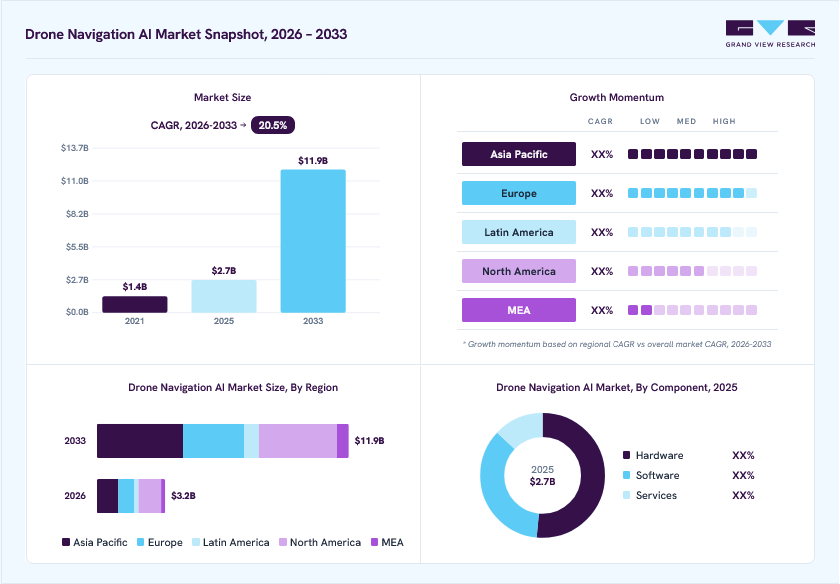
The global drone navigation AI market size was valued at USD 2.7 billion in 2025 and is projected to grow from USD 3.2 billion in 2026 to USD 11.9 billion by 2033, at a CAGR of 20.5% from 2026 to 2033. North America dominated the market, accounting for the largest revenue share of 33.3% in 2025. The market growth is primarily driven by the increasing deployment of autonomous unmanned aerial vehicles (UAVs), rising demand for GPS-denied navigation solutions, advancements in edge computing and computer vision, growing commercial drone applications, and the rapid adoption of AI-enabled swarm intelligence in modern military operations.
Key Market Trends & Insights
- By component: The hardware segment held the largest market share of 51.4% in 2025.
- By technology: The computer vision segment held the largest market share of 30.3% in 2025.
- By drone type: The multi-rotor segment held the largest market share of 51.3% in 2025.
- By end use: The commercial segment held the largest market share of 42.9% in 2025.
- By application: The surveillance & monitoring segment held the largest market share of 37.4% in 2025.
Regional Highlights
- Largest regional market: North America (33.3% revenue share, 2025)
- Fastest growing regional market: Asia Pacific (highest CAGR, 2026-2033)
- By country: The U.S. dominated North America with the largest revenue share in 2025
Market Size & Forecast
- Market size in 2025: USD 2.7 billion
- Estimated market size in 2026: USD 3.2 billion
- Projected market size by 2033: USD 11.9 billion
- CAGR (2026-2033): 20.5%
Commercial enterprises and defense organizations across developed and emerging economies are prioritizing drone fleet autonomy to replace legacy manual piloting with advanced, AI-driven navigation solutions. Operators are investing in next-generation flight controllers, visual SLAM algorithms, and autonomous path-planning software to enhance flight safety and operational efficiency. Autonomy initiatives also emphasize GPS-denied resilience, obstacle avoidance, and integration with advanced sensor fusion and mission-planning platforms, driving sustained demand for drone navigation AI across air, land, and naval deployment environments.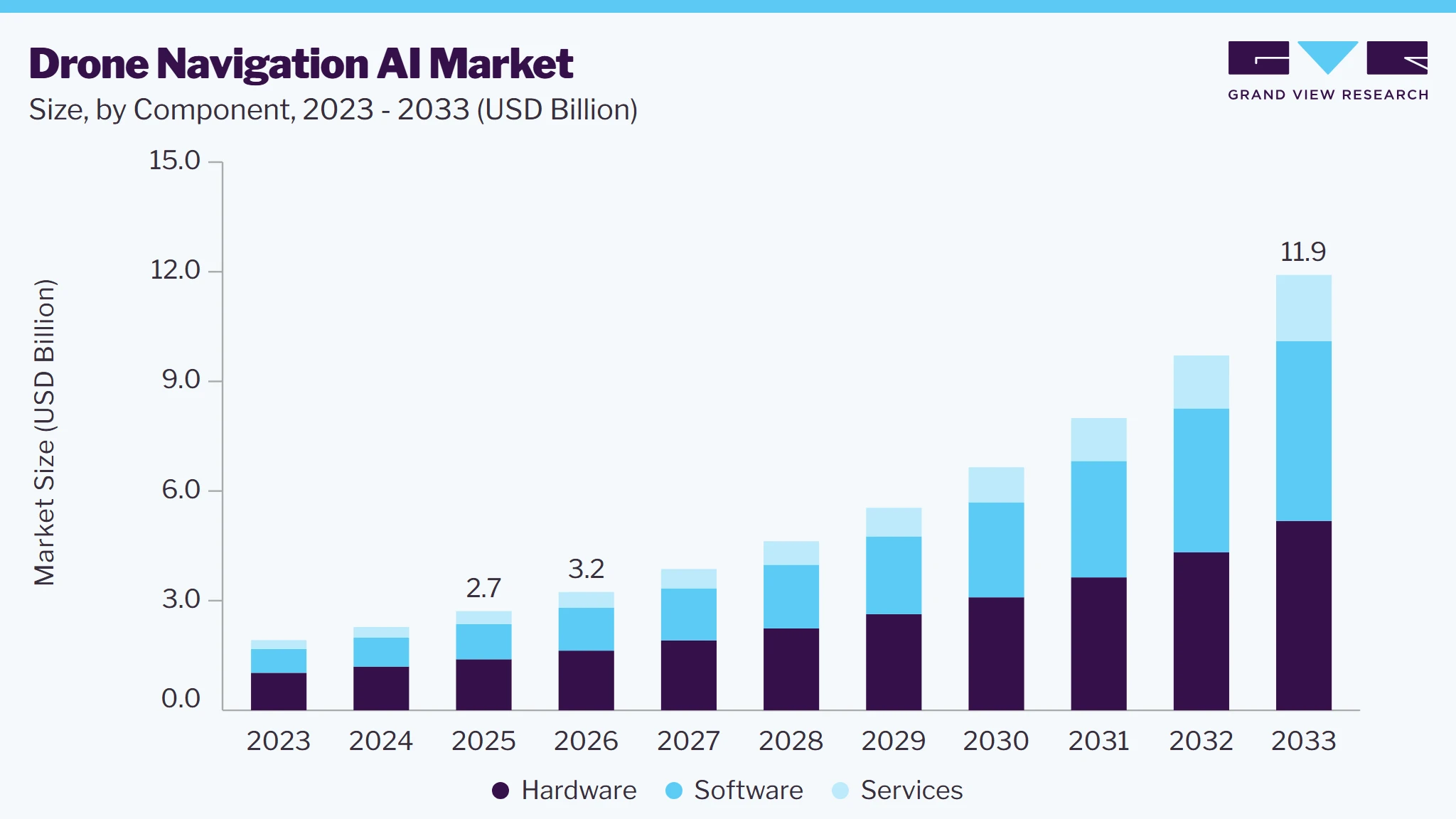
In addition, the growing operational risks in electronic warfare environments, severe signal jamming, and BVLOS (Beyond Visual Line of Sight) have prompted technology providers to expand R&D budgets. A significant portion of these investments is directed toward procuring sophisticated navigation algorithms capable of executing high-precision flight maneuvers without reliance on external satellite links. Increased defense and commercial spending enable organizations to acquire visual positioning systems, AI-driven flight control software, and intelligent obstacle-detection units, thereby supporting the expansion of the drone navigation AI industry.
Furthermore, modern drone applications require platforms that can accurately map complex environments, avoid dynamic obstacles, and reduce the risk of mission failure in GPS-denied areas. Drones equipped with advanced spatial AI software provide superior positioning accuracy, improved flight autonomy, and enhanced mission reliability compared to conventional GPS-bound flight controllers. This growing emphasis on complete operational independence has accelerated the adoption of vision-based navigation systems, autonomous path planners, and edge AI navigation hardware across commercial and defense fleets worldwide, which is expected to further drive market growth in the coming years.
Moreover, the integration of artificial intelligence (AI), deep reinforcement learning, and swarm robotics technologies is transforming modern uncrewed aerial operations. AI-enabled navigation systems can process multi-sensor flight data more efficiently, improve real-time spatial mapping, optimize trajectory generation, and support autonomous multi-agent drone formations. Edge computing hardware enables real-time, low-latency processing directly on board the aircraft, enhancing situational awareness and flight safety. These technological advancements are expanding the operational envelopes of uncrewed platforms and encouraging commercial enterprises and defense agencies to invest in next-generation autonomous flight systems.
Market Dynamics
The drone navigation AI industry is shaped by evolving airspace management regulations, increasing focus on BVLOS commercial operations, and advancements in onboard neural processing hardware. Growth is further supported by investments in dual-use technology development and international aerospace collaborations. However, high computational constraints, regulatory integration delays, and high safety certification costs remain key challenges. Ongoing innovation in vision-based spatial AI is expected to create new growth opportunities over the forecast period.
Modern uncrewed aerial operations increasingly require drones capable of executing complex flight trajectories with high precision while overcoming GPS jamming, spoofing, and satellite signal loss in urban or contested environments. This has accelerated the adoption of drone navigation AI equipped with advanced visual SLAM and optical flow technologies, enabling airborne platforms to maintain stable positioning across commercial inspections, search-and-rescue, and defense missions. The shift toward fully autonomous flight in degraded environments is increasing demand for intelligent navigation systems.
AI-driven visual positioning, LiDAR odometry, and neural inertial navigation offer real-time feature tracking, greater flight stability, and higher mission success rates than traditional GPS-dependent autopilots. Their ability to operate effectively in complex indoor, underground, and jammed environments has made them a core component of modern drone platform developments. Moreover, defense ministries and commercial fleet managers are increasing investments in signal-independent flight capabilities, driving sustained growth in the drone navigation AI industry.
The development of drone navigation AI requires sophisticated computer vision algorithms, low-power edge neural processing units, multi-sensor calibration platforms, and extensive simulation testing, making these software and hardware stacks significantly more expensive than standard flight controllers. High research and development expenditures, coupled with complex software verification processes, increase the overall cost of development and fleet deployment.
In addition, stringent aviation safety certifications and regulatory approval timelines can delay commercial rollouts, particularly for enterprise startups with limited capital. The need for continuous algorithmic training, system updates, and integration with diverse drone hardware frames further adds to lifecycle costs. These financial and computational challenges may limit rapid scaling and restrain market growth, especially among cost-sensitive commercial drone operators.
Increasing investments in BVLOS commercial logistics and autonomous swarm technologies present significant opportunities for the drone navigation AI industry. Civil aviation authorities and defense agencies are allocating substantial resources to establish regulatory frameworks and technological infrastructure that support autonomous multi-drone operations with minimal human oversight.
Emerging capabilities such as collaborative spatial mapping, decentralized swarm navigation, AI-driven airspace integration, and dynamic trajectory re-routing are creating new avenues for software innovation. Rising investments in last-mile delivery networks, critical infrastructure inspection, and defense swarm systems are expected to accelerate the adoption of technologically advanced navigation AI, supporting long-term market growth.
Market Concentration & Characteristics
The global drone navigation AI industry is moderately concentrated, with leading autonomy software developers, semiconductor providers, and defense contractors holding significant market positions through proprietary vision models, custom AI chips, and long-term enterprise integration partnerships. The market demonstrates a high degree of innovation, driven by advancements in neural SLAM, real-time depth estimation, sensor fusion, edge computing, and multi-agent coordination technologies. The market also sees active M&A, with major aerospace and tech firms acquiring specialized startups to strengthen capabilities in edge AI hardware, spatial computing, and signal-denied navigation.
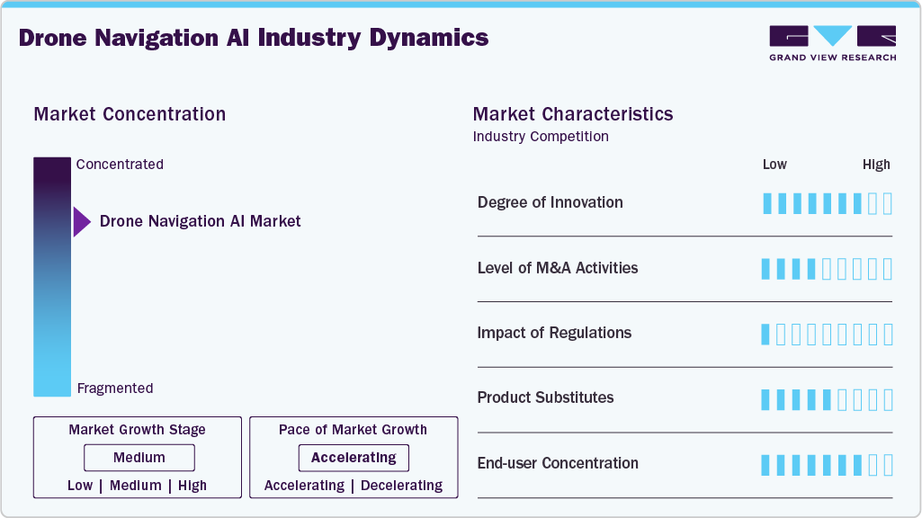
The drone navigation AI industry is significantly affected by evolving civil aviation regulations, BVLOS flight permits, airworthiness certifications, and export control regimes governing advanced AI hardware and dual-use algorithms. Drone navigation AI software has limited product substitutes due to its superior spatial awareness, signal-denied positioning capabilities, and adaptive flight control, although basic GPS-guided systems serve as lower-cost alternatives in non-critical hobbyist applications. The end-user landscape is moderately concentrated, comprising commercial logistics providers, industrial inspection firms, defense agencies, and enterprise survey organizations. However, expanding commercial delivery use cases and defense autonomy mandates across global regions are broadening adoption opportunities for AI navigation developers.
Analyst Perspective
The drone navigation AI market is poised for sustained exponential expansion, driven by rising global defense autonomous requirements, shifts in commercial BVLOS approvals, rapid advancements in edge neural chips, and the need for GPS-denied navigation. Growing investments in vision SLAM, reinforcement-learning flight controls, swarm intelligence, and low-power computing hardware modules, coupled with expanding industrial inspection demands in unmapped assets, are expected to accelerate market growth over the coming years.
Component Insights
The hardware segment led the market with the largest revenue share of 51.4% in 2025, driven by the increasing demand for high-performance processors, AI accelerators, cameras, LiDAR, radar, GNSS modules, inertial measurement units, communication systems, and other sensing and computing components required for autonomous drone navigation. Navigation AI depends heavily on onboard hardware capable of processing large volumes of sensor and visual data in real time while maintaining low power consumption and limited weight. Advances in edge computing and specialized AI processors are allowing drones to perform increasingly complex perception, object detection, path planning, and decision-making tasks directly onboard rather than relying entirely on cloud infrastructure.
The software segment is expected to grow at the fastest CAGR of 22.8% from 2026 to 2033, owing to the rapid development of AI-powered navigation algorithms, autonomous flight software, computer vision, sensor fusion platforms, path-planning systems, real-time decision-making technologies, and fleet management solutions. Advances in machine learning and AI are allowing drones to dynamically plan routes, identify and avoid obstacles, adapt to changing environments, and execute increasingly complex missions with limited human intervention. In addition, the growing use of software-defined autonomous systems enables manufacturers and operators to improve drone capabilities through algorithm and software updates without requiring major hardware modifications, supporting the rapid expansion of the software.
Technology Insights
The computer vision systems segment led the market with the largest revenue share of 30.3% in 2025, owing to the widespread integration of cameras, image-processing technologies, and AI algorithms, enabling drones to perceive and interpret their surroundings in real time. Growing demand for autonomous inspection, surveillance, mapping, and navigation is encouraging manufacturers to integrate increasingly sophisticated vision-based AI systems into drones. Improvements in onboard processing, machine learning models, high-resolution cameras, and real-time image analysis are further improving the accuracy and reliability of computer vision-based navigation.
The sensor fusion AI segment is expected to grow at the fastest CAGR from 2026 to 2033, driven by the increasing integration of data from cameras, LiDAR, radar, GNSS, inertial measurement units, ultrasonic sensors, and other onboard sensing technologies to improve the reliability and accuracy of autonomous navigation. Sensor fusion AI enables drones to combine information from multiple sensors to create a more comprehensive understanding of their surroundings than is typically achievable with a single sensing technology. This capability is particularly valuable in challenging conditions such as low visibility, dense urban environments, indoor locations, and GNSS-denied areas.
Drone Type Insights
The multi-rotor segment led the market with the largest revenue share of 51.3% in 2025, fueled by its high maneuverability, vertical takeoff and landing capabilities, hovering performance, compact design, and ability to operate effectively in confined and complex environments. These characteristics make multi-rotor drones particularly suitable for surveillance, inspection, mapping, security, emergency response, and infrastructure monitoring applications that require precise positioning and low-speed flight. The increasing availability of commercially and industrially focused multi-rotor platforms equipped with advanced onboard processors and sensors is also contributing to their widespread adoption.
The hybrid segment is expected to grow at the fastest CAGR from 2026 to 2033, driven by the growing demand for drones that combine the vertical takeoff and landing capabilities and maneuverability of multi-rotor systems with the longer flight endurance, range, and energy efficiency of fixed-wing aircraft. Hybrid drones are increasingly being considered for applications such as long-distance surveillance, infrastructure inspection, mapping, agriculture, logistics, and defense missions that require both precise takeoff and landing and extended autonomous flight. Advances in AI-based flight control, autonomous mission planning, sensor fusion, and navigation algorithms are enabling these systems to transition between different flight modes while maintaining stability and navigation accuracy.
End Use Insights
The commercial segment led the market with the largest revenue share of 42.9% in 2025, driven by the growing adoption of AI-powered drones across construction, agriculture, mining, energy, utilities, infrastructure inspection, surveying, mapping, and logistics. Commercial organizations are increasingly deploying drones equipped with AI-based navigation to automate repetitive aerial operations, improve inspection accuracy, reduce operational costs, and minimize human exposure to hazardous environments. AI navigation technologies enable drones to autonomously follow inspection routes, maintain stable positioning, avoid obstacles, and collect data consistently across large or difficult-to-access areas.
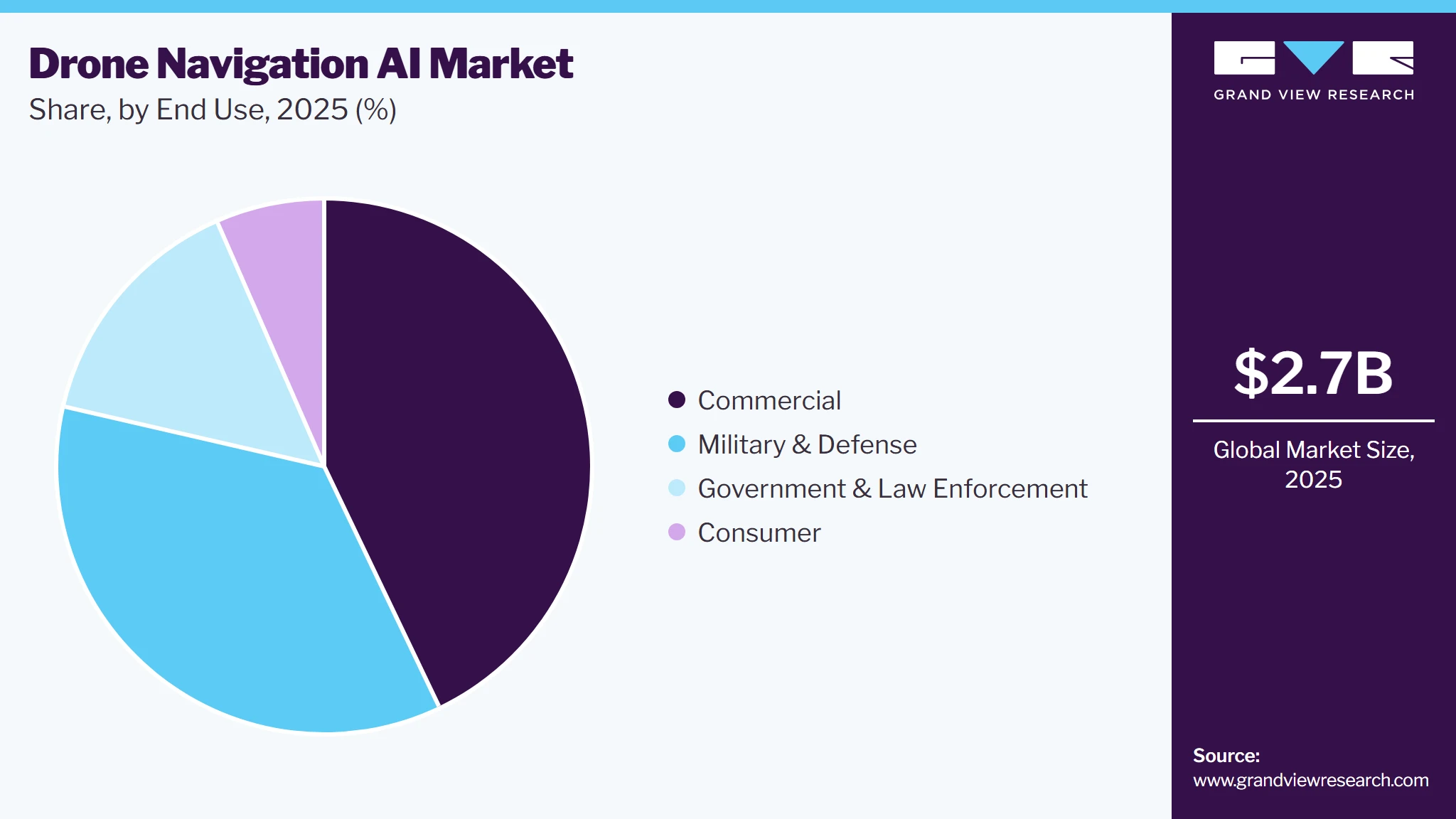
The government & law enforcement segment is expected to grow at the fastest CAGR from 2026 to 2033, driven by the rising use of autonomous drones for border surveillance, public safety, search and rescue, emergency response, reconnaissance, disaster management, traffic monitoring, and critical infrastructure protection. Government agencies and law enforcement organizations are increasingly seeking autonomous aerial systems capable of operating for extended periods while reducing the need for continuous manual piloting. Increasing government investments in unmanned systems, growing requirements for persistent surveillance, and advancements in AI-enabled autonomous operations are expected to further support adoption throughout the forecast period.
Application Insights
The surveillance & monitoring segment led the market with the largest revenue share of 37.4% in 2025, fueled by the increasing deployment of AI-enabled drones for real-time aerial surveillance, perimeter security, border monitoring, critical infrastructure protection, traffic monitoring, disaster assessment, and industrial inspection. AI-powered navigation enables drones to autonomously follow predefined or dynamically generated routes, detect and avoid obstacles, track moving objects, and operate in complex environments with limited human intervention. The growing need for persistent aerial monitoring, combined with improvements in computer vision, object recognition, autonomous flight control, and sensor technologies, is encouraging organizations and government agencies to adopt drone navigation AI solutions.
The logistics & delivery segment is expected to grow at the fastest CAGR from 2026 to 2033, driven by the increasing adoption of autonomous drones for last-mile delivery, rising demand for faster and contactless transportation, and advancements in AI-based route optimization, obstacle avoidance, and dynamic flight planning. Drone navigation AI allows delivery drones to identify suitable routes, respond to changing weather and environmental conditions, avoid obstacles, and navigate safely through increasingly complex airspaces. The expansion of e-commerce, healthcare delivery, food delivery, and remote-area logistics is creating demand for autonomous aerial transportation solutions.
Regional Insights
The North America drone navigation AI market held the largest revenue share of 33.3% in 2025, driven by substantial defense spending, high concentration of leading AI chip and drone software firms, and supportive FAA regulatory sandboxes for BVLOS flight testing. The region benefits from strong demand for autonomous commercial inspection drones, defense UAV modernization programs, and advanced logistics initiatives.

U.S. Drone Navigation AI Market Trends
The drone navigation AI market in the U.S. accounted for the largest revenue share in North America in 2025, supported by massive defense allocations for autonomous UAV programs, rapid commercial drone integration, and pioneering developments in edge computing hardware. Federal agencies and enterprise fleet managers are investing heavily in GPS-denied navigation, vision SLAM, and swarm control software to maintain technological leadership in aerial autonomy.
Europe Drone Navigation AI Market Trends
The drone navigation AI market in Europe is expected to grow at a significant CAGR of over 20.9% from 2026 to 2033, propelled by unified EASA regulations for drone operations, expanding industrial inspection applications, and heightened regional defense readiness initiatives. European nations are actively funding dual-use autonomous technologies to improve critical infrastructure monitoring and strengthen sovereign defense capabilities.
The Germany drone navigation AI market is driven by strong industrial automation, advanced automotive and aerospace engineering hubs, and increasing adoption of autonomous UAVs for factory logistics and energy grid inspection. Ongoing partnerships between technological research institutes and commercial drone developers further propel market expansion.
The drone navigation AI market in the UK is witnessing rapid expansion. Government frameworks supporting BVLOS integration, urban air mobility flight corridors, and defense innovation funds are driving steady demand for spatial AI positioning platforms and signal-resilient flight systems across civilian and military domains.
Asia Pacific Drone Navigation AI Market Trends
The drone navigation AI market in the Asia Pacific is expected to grow at the fastest CAGR of 21.9% from 2026 to 2033, driven by massive commercial drone manufacturing ecosystems, rapidly expanding agricultural automation, and regional defense spending on unscrewed systems. Countries across the region are aggressively deploying vision-based flight autonomy to lower operational costs in mega-infrastructure and logistics networks.
The China drone navigation AI market is being accelerated by extensive public funding for AI research and widespread adoption of autonomous aerial solutions in industrial mapping and agriculture. Domestic software developers are rapidly embedding proprietary vision SLAM and edge computing modules into commercial and military uncrewed platforms, thereby supporting market growth in China.
The drone navigation AI market in Japan is expanding steadily, supported by government initiatives to integrate autonomous delivery drones to address labor shortages and rural logistics challenges. High demand for automated structural inspection in earthquake-prone infrastructure drives continuous adoption of indoor, non-GPS visual positioning systems.
Key Drone Navigation AI Company Insights
Some of the key players operating in the market include DJI and Aerovironment, Inc., among others.
-
DJI is a China-based technology company that develops and manufactures drones, aerial imaging systems, and flight-control technologies, with advanced AI-enabled navigation, computer vision, obstacle sensing, and autonomous flight capabilities. Its navigation technologies integrate visual perception, LiDAR, infrared sensing, and other sensor data to support real-time positioning, obstacle avoidance, and autonomous route planning. DJI also provides developer platforms that support motion planning, advanced vision, custom navigation, and autonomous flight applications.
-
AeroVironment, Inc. is a U.S.-based defense technology company that develops autonomous unmanned aircraft systems, intelligent robotic platforms, and AI-enabled autonomy solutions for defense and mission-critical applications. The company integrates computer vision, machine learning, autonomous mission execution, and advanced navigation capabilities into its unmanned systems. Its AVACORE software and Autonomy Retrofit Kit enable autonomous single- and multi-vehicle missions, including search, tracking, and following operations, strengthening its position as a mature player in AI-driven drone navigation and autonomy.
Skydio, Inc., and Shield AI. are some of the emerging market participants in the drone navigation AI industry.
-
Skydio is a U.S.-based autonomous drone company specializing in AI-powered navigation and computer vision. Its Skydio Autonomy platform enables drones to understand their surroundings, navigate complex environments in real time, and automatically avoid obstacles. The company is expanding autonomous drone applications across inspection, mapping, public safety, security, and defense, making it one of the strongest emerging players in AI-based drone navigation.
-
Shield AI is a defense technology company specializing in military-grade flight autonomy and swarm intelligence through its proprietary Hivemind AI pilot. The system enables multi-agent uncrewed systems to execute complex tactical missions in signal-jammed environments without GPS or human communications. Shield AI benefits from major defense department contracts, combat-proven software integration, and deep expertise in edge-computed adaptive decision-making algorithms.
Key Drone Navigation AI Companies
The following key companies have been profiled for this study on the drone navigation AI market.
-
Skydio, Inc.
-
SZ DJI Technology Co., Ltd
-
AeroVironment, Inc.
-
EHang
-
Parrot Drones SAS
-
Delair SAS
-
Anduril Industries
-
Skycatch, Inc.
-
Dronehub.ai
-
DroneShield Ltd
Competitive Benchmarking
Category
Operating Strategies
Competitive Edge
Weakness
Established Players (Lockheed Martin Corporation, SZ DJI Technology Co., Ltd., Aerovironment, Inc.)
- Focus on long-term defense procurement programs, military airworthiness certifications, and enterprise infrastructure inspection platforms.
- Invest heavily in edge AI hardware, GPS-denied neural flight control, and multi-agent swarm platforms.
- High technical expertise in signal-denied positioning, hardened edge hardware, and military-grade safety certification.
- Strong global distribution and institutional customer lock-in.
- High computational unit cost and long software certification cycles.
- Slower adaptability to rapid open-source AI developer shifts.
Emerging Players (Skydio, Inc., Shield AI, Skycatch, Inc., Dronehub AI)
- Focus on modular vision-inertial computing boards, plug-and-play visual SLAM algorithms, indoor spatial mapping, and platform-agnostic autonomy kits.
- Expand presence through OEM partnerships and specialized industrial inspection contracts.
- Rapid software iteration cycles, platform flexibility, and specialized expertise in indoor, subterranean, and warehouse spatial navigation.
- Smaller capital reserves and limited manufacturing scale compared to tier-1 defense prime contractors.
- Higher reliance on OEM hardware integrators.
Recent Developments
-
In July 2026, Aerovironment, Inc. launched/expanded the P550 autonomous eVTOL platform through a U.S. Army production contract. The P550 combines advanced AI autonomy with autonomous flight, object detection/classification, and operations in GPS-challenged environments.
-
In May 2026, Shield AI was selected by the U.S. Department of Defense to integrate its Hivemind autonomy software into the LUCAS (Low-Cost Uncrewed Combat Attack System) program, enabling groups of drones to coordinate, maneuver, and adapt to changing conditions in real time.
-
In February 2026, DJI Enterprise announced the Drone Onboard AI Challenge 2026 to accelerate the development and deployment of onboard AI solutions for drones, integrating AI algorithms with flight control, sensor data, and route-planning capabilities to enable more intelligent and automated drone operations.
Drone Navigation AI Market Report Scope
Report Attribute
Details
Market size in 2025
USD 2.7 billion
Estimated market size in 2026
USD 3.2 billion
Projected market size by 2033
USD 11.9 billion
Growth rate
CAGR of 20.5% from 2026 to 2033
Base year of estimation
2025
Historical data
2021 - 2024
Forecast period
2026 - 2033
Quantitative units
Revenue in USD billion and CAGR from 2026 to 2033
Report coverage
Revenue forecast, company ranking, competitive landscape, growth factors, and trends
Segments covered
Component, technology, drone type, end use, application, region
Regional scope
North America; Europe; Asia Pacific; Latin America; Middle East, and Africa
Country scope
U.S.; Canada; Mexico; Germany; UK; France; China; Japan; India; South Korea; Australia; Brazil; UAE; Saudi Arabia; South Africa
Key companies profiled
Skydio, Inc.; SZ DJI Technology Co., Ltd.; AeroVironment, Inc.; EHang; Parrot Drones SAS; Delair SAS; Anduril Industries; Skycatch, Inc.; Dronehub.ai; DroneShield Ltd.
Customization scope
Free report customization (equivalent up to 8 analysts working days) with purchase. Addition or alteration to country, regional & segment scope.
Pricing and purchase options
Avail customized purchase options to meet your exact research needs. Explore purchase options
Global Drone Navigation AI Market Report Segmentation
This report forecasts revenue growth at global, regional, and country levels and provides an analysis of the latest industry trends in each of the sub-segments from 2021 to 2033. For this study, Grand View Research has segmented the global drone navigation AI market report based on component, technology, drone type, end use, application, and region.
-
Component Outlook (Revenue, USD Billion, 2021 - 2033)
-
Hardware
-
Software
-
Services
-
-
Technology Outlook (Revenue, USD Billion, 2021 - 2033)
-
Machine Learning
-
Computer Vision
-
Deep Learning
-
Sensor Fusion AI
-
Others
-
-
Drone Type Outlook (Revenue, USD Billion, 2021 - 2033)
-
Fixed-Wing
-
Multi-Rotor
-
Single-Rotor
-
Hybrid
-
-
End Use Outlook (Revenue, USD Billion, 2021- 2033)
-
Consumer
-
Commercial
-
Military & Defense
-
Government & Law Enforcement
-
-
Application Outlook (Revenue, USD Billion, 2021 - 2033)
-
Inspection & Maintenance
-
Mapping & Surveying
-
Surveillance & Monitoring
-
Agriculture
-
Logistics & Delivery
-
Others
-
-
Regional Outlook (Revenue, USD Billion, 2021 - 2033)
-
North America
-
U.S.
-
Canada
-
Mexico
-
-
Europe
-
Germany
-
UK
-
France
-
-
Asia Pacific
-
China
-
Japan
-
India
-
South Korea
-
Australia
-
-
Latin America
-
Brazil
-
-
Middle East and Africa (MEA)
-
UAE
-
Saudi Arabia
-
South Africa
-
-
Research Methodology
The drone navigation AI marketfigures in this report are based on a proven research process that combines executive interviews with secondary research from proprietary databases, company filings, and recognized regulatory and institutional sources. Market size is built through value-chain sizing-reconciling supply-side and demand-side estimates-and triangulated with bottom-up and top-down approaches. Every estimate passes multiple levels of expert validation before publication, with eachdrone navigation AI segment quantified using the revenue-capture definitions in the table below.
Segment Definition
Segment - Type
Revenue capture definition
Hardware
Revenue is generated through the sale of AI processors, cameras, LiDAR, radar, GNSS modules, IMUs, sensors, and other hardware used for autonomous drone navigation.
Software
Revenue is generated through AI navigation software, path planning, obstacle avoidance, localization, autonomous flight control, and navigation platforms.
Services
Revenue is generated through navigation-system integration, deployment, customization, maintenance, technical support, training, and consulting services.
Segment -Technology
Revenue capture definition
Machine Learning
Revenue is generated through machine-learning algorithms used for route optimization, navigation decisions, localization, trajectory prediction, and autonomous flight.
Computer Vision
Revenue is generated through AI-based visual perception, object detection, obstacle recognition, visual positioning, and vision-based navigation technologies.
Deep Learning
Revenue is generated through deep-learning models used for obstacle detection, scene recognition, path planning, localization, and autonomous navigation.
Sensor Fusion AI
Revenue is generated through AI systems that combine camera, LiDAR, radar, GNSS, IMU, and other sensor data to improve drone navigation and positioning.
Others
Revenue is generated through other AI-based navigation technologies, including optimization algorithms, fuzzy logic, and autonomous decision-making systems.
Segment - Drone Type
Revenue capture definition
Fixed-Wing
Revenue is generated through AI navigation systems integrated into fixed-wing drones for autonomous flight, route planning, positioning, and mission execution.
Multi-Rotor
Revenue is generated through AI navigation systems for multi-rotor drones, enabling autonomous flight, hovering, obstacle avoidance, positioning, and path planning.
Single-Rotor
Revenue is generated through AI navigation technologies used in single-rotor drones for autonomous flight control, positioning, obstacle avoidance, and mission planning.
Hybrid
Revenue is generated through AI navigation systems used in hybrid drones for autonomous flight, route planning, obstacle avoidance, and transition between flight modes.
Segment - End Use
Revenue capture definition
Consumer
Revenue is generated through AI navigation features in consumer drones, including automated flight, obstacle avoidance, subject tracking, and intelligent positioning.
Commercial
Revenue is generated through AI navigation solutions used by businesses for inspection, surveying, construction, agriculture, energy, mining, logistics, and other commercial operations.
Military & Defense
Revenue is generated through AI navigation systems used in military UAVs for autonomous flight, reconnaissance, surveillance, mission planning, GPS-denied navigation, and swarm operations.
Government & Law Enforcement
Revenue is generated through AI navigation solutions used for public safety, surveillance, border monitoring, search and rescue, emergency response, and law enforcement operations.
Segment - Application
Revenue capture definition
Inspection & Maintenance
Revenue is generated through AI navigation systems that enable autonomous flight paths, obstacle avoidance, and repeatable routes for infrastructure and asset inspection.
Mapping & Surveying
Revenue is generated through AI-based autonomous flight planning, positioning, terrain navigation, and route optimization for mapping and surveying operations.
Surveillance & Monitoring
Revenue is generated through AI navigation technologies that enable autonomous patrolling, route planning, target tracking, obstacle avoidance, and continuous aerial monitoring.
Agriculture
Revenue is generated through AI navigation systems used for autonomous field coverage, crop monitoring, spraying, mapping, and precision agriculture operations.
Logistics & Delivery
Revenue is generated through AI-based route planning, dynamic navigation, obstacle avoidance, landing-site selection, and autonomous delivery operations.
Others
Revenue is generated through AI navigation technologies used in search and rescue, disaster response, environmental monitoring, communications, and other emerging drone applications.
Estimation Model
Layer Name
Key Question
Description
Drone Navigation AI Technology & Enablement Layer
What technologies and systems enable AI-powered drone navigation capabilities?
Represents the core technologies, components, and enabling systems that support autonomous drone navigation. Includes machine learning, computer vision, deep learning, sensor fusion AI, AI processors, GNSS/GPS, LiDAR, radar, cameras, IMUs, ultrasonic sensors, edge computing, SLAM, localization, path planning, obstacle detection and avoidance, autonomous flight control, and secure communication technologies that improve navigation accuracy, situational awareness, flight autonomy, and operational reliability.
Drone Navigation AI Platform, Application & End-User Layer
Where is drone navigation AI deployed, and which end-use segments generate demand?
Represents the drone platforms, applications, and end users driving demand for navigation AI solutions. Key platforms include fixed-wing, multi-rotor, single-rotor, and hybrid drones. Major applications include inspection and maintenance, mapping and surveying, surveillance and monitoring, agriculture, logistics and delivery, search and rescue, and disaster response. Primary end users include consumer, commercial, military & defense, and government & law enforcement organizations seeking improved autonomy, navigation accuracy, safety, operational efficiency, and reduced reliance on manual piloting.
Drone Navigation AI Integration & Lifecycle Management Layer
How are Drone Navigation AI solutions developed, integrated, deployed, and maintained throughout their lifecycle?
Covers the development, integration, testing, deployment, optimization, and lifecycle support of AI-enabled drone navigation systems. Includes AI model development and training, navigation software integration, sensor integration, flight-control integration, system testing and validation, simulation, calibration, autonomous mission planning, software and firmware updates, cybersecurity, technical support, maintenance, performance optimization, and system upgrades to ensure reliable and continuous autonomous navigation throughout the drone's operational lifecycle.
Drone Navigation AI Commercialization & Market Monetization Layer
How is revenue generated in the drone navigation AI market?
Revenue is generated through the development, sale, integration, deployment, and lifecycle support of AI-powered drone navigation technologies and solutions. Key revenue streams include navigation hardware, AI processors and sensors, navigation software, autonomous flight platforms, AI algorithms, computer vision and sensor fusion solutions, navigation system integration, professional services, technical support, maintenance, software upgrades, training, and managed autonomous drone services. Revenue is generated by drone manufacturers, AI technology providers, navigation-system developers, software companies, system integrators, and service providers serving consumer, commercial, military & defense, and government & law enforcement customers.
Delivered Customizations
This report has been delivered with the following In-depth customizations
Client Request
Customization Delivered
Value Adds
Market Sizing, Segmentation & Growth Opportunity Assessment
Assessed the global drone navigation AI market size, historical trends, forecast growth outlook, and detailed segmentation by Component (Hardware, Software, Services), Technology (Machine Learning, Computer Vision, Deep Learning, Sensor Fusion AI, Others), Drone Type (Fixed-Wing, Multi-Rotor, Single-Rotor, Hybrid), End Use (Consumer, Commercial, Military & Defense, Government & Law Enforcement), and Application (Inspection & Maintenance, Mapping & Surveying, Surveillance & Monitoring, Agriculture, Logistics & Delivery, Others).
Enables drone manufacturers, AI technology providers, defense organizations, commercial operators, government agencies, and investors to identify high-growth segments, prioritize AI and navigation technology investments, optimize product portfolios, and capture revenue opportunities across autonomous flight, intelligent navigation, obstacle avoidance, mapping, surveillance, inspection, agriculture, and drone delivery applications.
Technology & Flight Autonomy Innovation Analysis
Evaluated adoption of next-generation navigation algorithms, including signal-denied positioning, neural SLAM, real-time depth estimation, dynamic swarm coordination, and edge AI processing hardware.
Helps software vendors and drone OEMs evaluate emerging autonomy stacks, improve positioning resilience in jammed airspaces, and meet civil aviation safety standards.
Regional Regulatory & Defense Procurement Analysis
Assessed regional demand across North America, Europe, Asia Pacific, Latin America, and the Middle East & Africa, evaluating defense spending, BVLOS regulatory frameworks, civil aviation sandboxes, and commercial adoption trends.
Provides actionable guidance on regulatory pathways, regional sales hotspots, and defense partnership opportunities across major commercial and military drone markets.
Frequently Asked Questions About This Report
By technology, the computer vision segment led the market with a share of over 30.3% in 2025.
By drone type, the multi-rotor segment led the market with a share of over 51.3% in 2025.
The commercial segment held the largest market share of 42.9% in 2025.
The global drone navigation AI market size was estimated at USD 2.7 billion in 2025 and is projected to reach USD 3.2 billion in 2026.
The global drone navigation AI market is expected to reach USD 11.9 billion by 2033, growing at a CAGR of 20.5% from 2026 to 2033
By component, the hardware segment accounted for the largest revenue share of over 51.4% in 2025.
North America accounted for the largest revenue share of 33.3% in 2025.
The increasing deployment of autonomous unmanned aerial vehicles (UAVs), rising demand for GPS-denied navigation solutions, advancements in edge computing and computer vision, growing commercial drone applications, and the rapid adoption of AI-enabled swarm intelligence in modern military operations are the key factors driving the market growth.
Skydio, Inc.; SZ DJI Technology Co., Ltd.; AeroVironment, Inc.; EHang; Parrot Drones SAS; Delair SAS; Anduril Industries; Skycatch, Inc.; Dronehub.ai; and DroneShield Ltd. are the key players in the market.
About the Author(s)
Next Generation Technologies Research Team
Technology · Next Generation TechnologiesThis report was authored by the next generation technologies research team at Grand View Research - comprising two research analysts, one senior research analyst, and one industry expert - with specialized expertise in the next generation technologies segment of the technology industry. All findings are based on proprietary technology databases, executive interviews, and regulatory analysis, subject to internal peer review prior to publication.
Last Updated:
Speak to Analyst


Customize this report to your needs — add regions, segments, or data points, with 20% free customization.
Or view our licence options:


ISO 9001:2015 & 27001:2022 Certified
We are GDPR and CCPA compliant! Your transaction & personal information is safe and secure. For more details, please read our privacy policy.


