
- Home
- »
- Next Generation Technologies
- »
-
Geospatial Intelligence Market Size, Share Report 2026-2033GVR Report cover
![Geospatial Intelligence Market (2026 - 2033)Report]()
Geospatial Intelligence Market (2026 - 2033)
Size, Share & Trends Analysis Report By Component (Software, Services), By Technology (Vector & GIS Analytics, Geo-visualization), By Application, By Industry, By Region, And Segment Forecasts
Market Size, 2025
$32.1BMarket Estimate, 2026
$35.7BMarket Forecast, 2033
$81.0BCAGR, 2026–2033
12.4%Geospatial Intelligence Market Summary
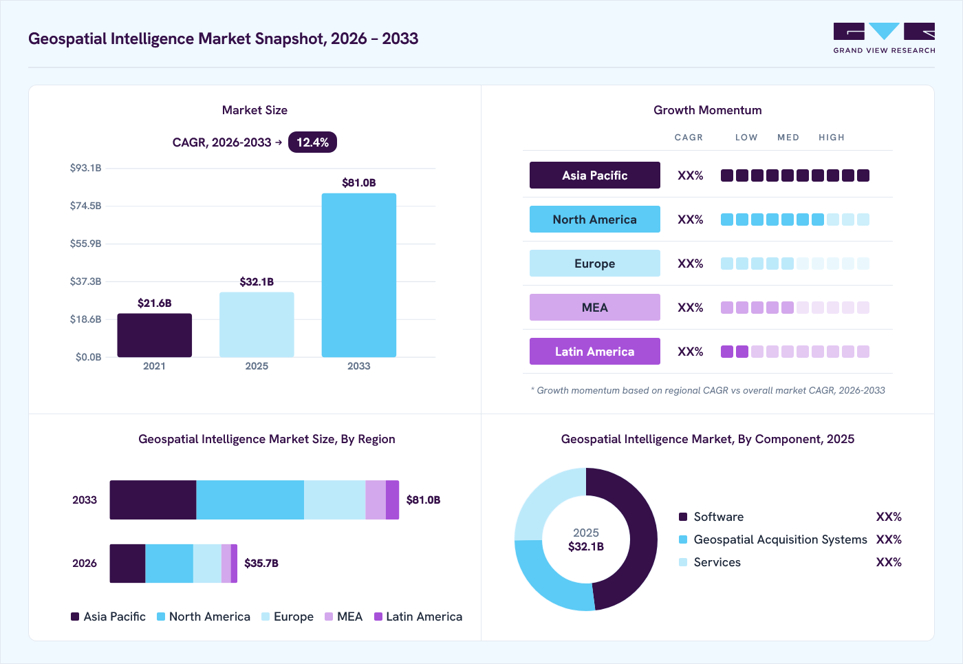
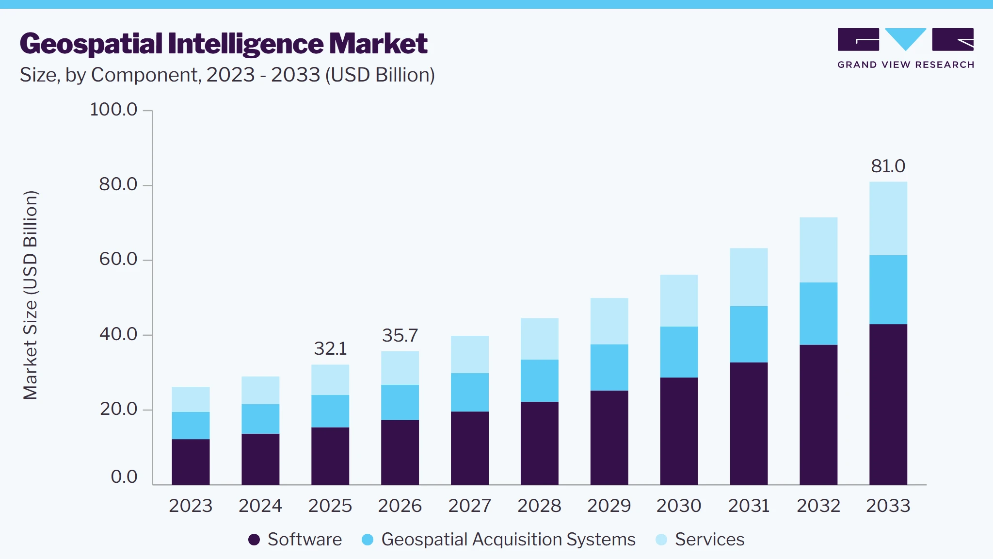
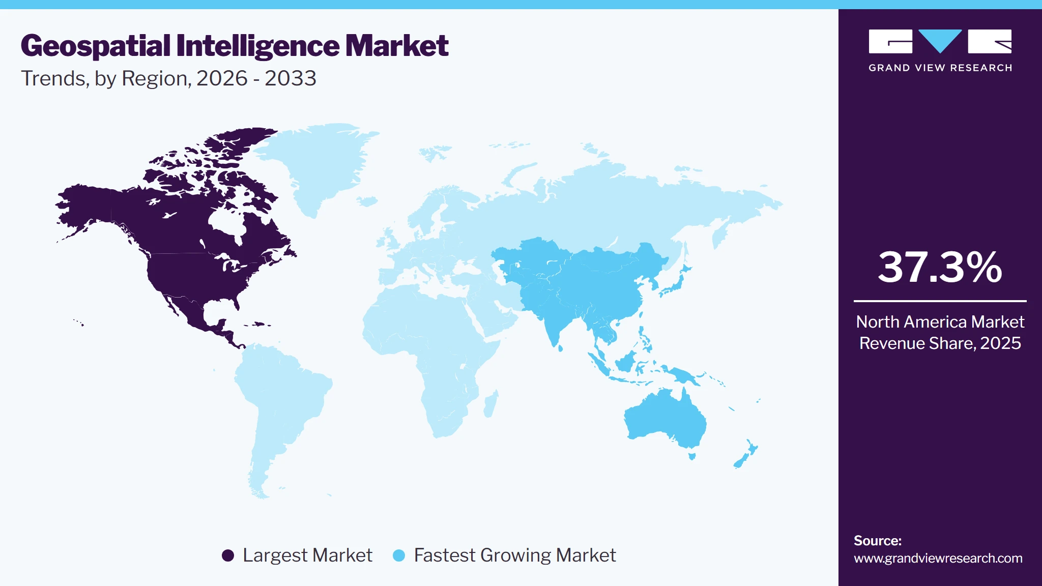
The global geospatial intelligence market size was valued at USD 32.1 billion in 2025 and is projected to grow from USD 35.7 billion in 2026 to USD 81.0 billion by 2033, at a CAGR of 12.4% from 2026 to 2033. North America dominated the market, accounting for a revenue share of 37.3% in 2025. The market is driven by rising demand for satellite imagery and geospatial data, AI & machine learning adoption, investments in Earth observation and remote sensing, and multi-source data integration for national security and operational decision-making.
Key Market Trends & Insights
- By component: Software segment held the largest revenue share of 47.9% in 2025.
- By technology: Vector & GIS analytics segment led the market with a revenue share of 36.7% in 2025.
- By application: Surveillance & security registering the fastest CAGR of 13.4% from 2026 to 2033.
Regional Highlights
- Largest regional market: North America (37.3% revenue share, 2025)
- Fastest-growing regional market: Asia Pacific (highest CAGR, 2026-2033)
- By country: The U.S. held the largest market share in 2025
Market Size & Forecast
- Market size in 2025: USD 32.1 Billion
- Estimated market size in 2026: USD 35.7 Billion
- Projected market size by 2033: USD 81.0 Billion
- CAGR (2026-2033): 12.4%
Three ways to get this report
Buy it, customize it, or ask a question.Ask an Analyst
A direct answer, usually in 1 working day
- AccessReport author, directly
- Reply timeWithin 1 working day
- No sales callDirect answer only
- FormatEmail reply
- CostFree, no cost
Get the Full Report
What the study covers
- FormatsPDF · Excel · Dashboard
- Timeline2026–2033 annual, 2025 base
- Coverage20+ countries, 5 regions
- Companies10+ key players profiled
Customize the Report
20% free customization
- IncludeCountries, segments, points
- TailorTo your product definition
- ExtendDeeper competitor detail
- OrA fully bespoke study
- Turnaround5–10 working days
The demand for geospatial intelligence is increasing as defense and government organizations accelerate the adoption of advanced geospatial capabilities for intelligence, surveillance, reconnaissance, border monitoring, mission planning, and situational awareness. Military and intelligence agencies are investing in high-resolution satellite imagery, synthetic aperture radar (SAR), aerial and UAV-based sensing, GIS platforms, remote sensing technologies, and advanced geospatial analytics to obtain timely and accurate information across complex operational environments.Market Dynamics
The geospatial intelligence market is experiencing significant growth, driven by increasing demand for satellite imagery, real-time geospatial information, advanced spatial analytics, and intelligence capabilities across defense, government, and commercial applications. Defense and intelligence organizations are expanding the use of geospatial intelligence (GEOINT) for intelligence, surveillance and reconnaissance (ISR), border monitoring, mission planning, threat assessment, and situational awareness. The integration of high-resolution satellite imagery, aerial and UAV-based data, GIS platforms, remote sensing, synthetic aperture radar (SAR), and geospatial data-fusion technologies is improving the speed and accuracy of intelligence generation.
The geospatial intelligence market is primarily driven by increasing requirements for timely and accurate location-based information to support defense operations, national security, disaster response, infrastructure monitoring, and strategic decision-making. Government and defense organizations are increasingly using satellite imagery, aerial imagery, UAV data, SAR, GIS, and other geospatial sources to monitor borders, detect changes, assess threats, conduct terrain analysis, and support mission planning. The growing deployment of commercial Earth-observation satellites and high-resolution imaging platforms is further expanding the availability of geospatial data. In parallel, the integration of AI, machine learning, computer vision, and automated image analysis is enabling organizations to process large volumes of imagery and identify objects, activities, and changes more rapidly. These capabilities are increasing the value of GEOINT for real-time situational awareness and operational decision-making.
Despite strong growth prospects, the geospatial intelligence market faces challenges associated with the high cost and technical complexity of acquiring, processing, storing, and managing large volumes of geospatial data. High-resolution satellite imagery, SAR data, aerial imagery, LiDAR, and other specialized datasets can require significant investment in acquisition infrastructure, processing platforms, storage, and analytical capabilities. Integrating data from multiple sources can also create challenges related to different formats, spatial resolutions, coordinate systems, data quality, and interoperability. In addition, sensitive GEOINT datasets require robust cybersecurity, access controls, encryption, and secure cloud or on-premises infrastructure. Regulatory restrictions related to satellite imagery, data sovereignty, privacy, and cross-border data sharing can further complicate deployment. The requirement for specialized expertise in remote sensing, GIS, spatial analytics, AI, and data science can also increase implementation costs and limit adoption among organizations with limited technical capabilities.
The increasing development of AI-enabled geospatial analytics, commercial satellite constellations, real-time monitoring platforms, digital twins, and multi-source data-fusion technologies is creating substantial opportunities for market participants. AI and machine learning can automatically analyze satellite and aerial imagery to identify objects, detect changes, classify terrain, monitor infrastructure, and generate actionable intelligence at significantly higher speeds. Predictive geospatial analytics can combine historical and real-time datasets to support risk assessment, disaster forecasting, infrastructure planning, and security operations. The expansion of commercial Earth-observation satellite constellations is also increasing the frequency and availability of high-resolution geospatial data for both government and commercial users. Furthermore, integrating satellite imagery with UAV data, IoT sensors, GNSS information, GIS databases, and other non-imagery sources can provide more comprehensive intelligence. These developments are creating opportunities for GEOINT software providers, satellite operators, geospatial analytics companies, GIS technology providers, AI companies, data providers, defense contractors, and geospatial service providers.
Market Concentration & Characteristics
The geospatial intelligence market is moderately concentrated, with competition led by established geospatial technology, aerospace, defense, satellite, and intelligence companies with strong capabilities in satellite imagery, remote sensing, GIS, geospatial analytics, Earth observation, AI-enabled intelligence, data processing, and geospatial services. The market is characterized by continuous advancements in high-resolution Earth observation, synthetic aperture radar (SAR), multispectral and hyperspectral imaging, UAV-based data acquisition, real-time geospatial analytics, AI and machine learning, automated image interpretation and multi-source data fusion. High costs associated with satellite and geospatial data infrastructure, complex data-processing requirements, stringent government and defense security standards, cybersecurity requirements, regulatory restrictions, and the need for specialized technical expertise create significant barriers to entry. These factors enable established companies to maintain strong competitive positions through technological innovation, government contracts, strategic partnerships, satellite programs, data-sharing agreements, platform integration, and long-term geospatial intelligence service contracts.
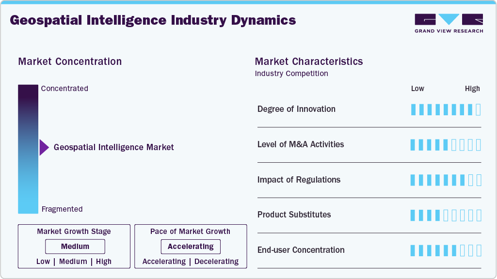
Major players such as Maxar Technologies, Hexagon AB, BlackSky Technology Inc. & Palantir Technologies Inc. compete across different segments of the geospatial intelligence market through investments in Earth-observation satellites, high-resolution imagery, GIS platforms, AI-enabled analytics, cloud-based geospatial platforms, remote sensing technologies, and intelligence solutions. Companies are increasingly focused on improving imagery resolution, revisit frequency, data processing speed, geospatial accuracy, real-time intelligence, automated object detection, and integration of multi-source datasets. The growing requirement for persistent surveillance, border monitoring, infrastructure assessment, disaster response, environmental monitoring, and mission planning is encouraging government and commercial organizations to invest in advanced GEOINT platforms and services. At the same time, the increasing availability of commercial satellite imagery and the integration of AI, cloud computing, IoT, UAVs, and real-time analytics are expanding the competitive landscape beyond traditional defense contractors toward specialized commercial geospatial technology providers.
Analyst Perspective
The geospatial intelligence market is expected to witness steady growth, supported by increasing defense spending, fleet modernization initiatives, and the growing need for strategic and tactical military airlift capabilities. Defense forces are investing in advanced fixed-wing transport aircraft, rotorcraft, high-payload platforms, modern technology systems, advanced avionics, secure communication systems, and mission systems to enhance the rapid movement of personnel, equipment, and supplies. The replacement of aging transport fleets and increasing requirements for humanitarian assistance, disaster relief, medical evacuation, and special operations are further supporting demand.
Component Insights
The software segment held the largest revenue share of 47.9% of the geospatial intelligence market in 2025, driven by the increasing adoption of advanced geospatial analytics platforms, GIS software, remote sensing applications, and AI-enabled intelligence solutions. These software solutions are extensively used for satellite imagery analysis, spatial data processing, mapping, visualization, intelligence generation, and real-time situational awareness across defense, government, and commercial applications.
Services segment is expected to witness a significant growth over the forecast period, driven by increasing demand for geospatial data acquisition, processing, analytics, consulting, system integration, and managed intelligence services. Organizations are increasingly outsourcing complex geospatial activities to specialized providers to access satellite imagery, remote sensing data, GIS expertise, AI-enabled analytics, and real-time intelligence capabilities without developing extensive in-house infrastructure.
Technology Insights
The vector & GIS analytics segment led the market with the largest share of 36.7% in 2025, driven by the widespread use of geographic information systems (GIS) and vector-based spatial analytics for mapping, location intelligence, terrain analysis, asset management, and operational planning. These technologies enable organizations to analyze geographic features such as roads, boundaries, infrastructure, facilities, and networks, supporting applications across defense, government, utilities, transportation, urban planning, and environmental monitoring.
Geovisualization segment is expected to witness significant growth in the geospatial intelligence market, driven by increasing demand for interactive maps, 3D visualization, spatial dashboards, and immersive geospatial environments for interpreting complex location-based information. Geovisualization enables defense agencies, government organizations, and commercial users to visualize terrain, infrastructure, assets, movement patterns, and environmental changes, supporting situational awareness, mission planning, urban development, and operational decision-making.
Application Insights
The asset monitoring & management segment held the largest share of 29.0% in 2025, driven by increasing use of geospatial intelligence to monitor, manage, and optimize geographically distributed physical assets and infrastructure. GEOINT solutions enable organizations to track asset locations, assess condition, detect changes, monitor surrounding environments, and support maintenance and operational planning across sectors such as defense, energy and utilities, transportation, telecommunications, and construction.
The risk assessment & modeling segment is expected to witness significant growth in the Geospatial Intelligence Market, driven by increasing adoption of geospatial data and spatial analytics to identify, assess, and predict geographic risks across defense, insurance, infrastructure, energy, agriculture, and disaster management applications. GEOINT solutions enable organizations to analyze terrain, environmental conditions, historical patterns, asset locations, and changing geographic conditions to assess exposure to natural hazards, security threats, infrastructure vulnerabilities, and operational risks.
Industry Insights
The Government & Defense segment led the market with the largest revenue share of 39.1% of the geospatial intelligence market in 2025, driven by the extensive use of GEOINT for national security, intelligence, surveillance and reconnaissance (ISR), border monitoring, mission planning, threat assessment, and military operations. Government and defense agencies rely on satellite imagery, aerial and UAV data, GIS platforms, remote sensing, and geospatial analytics to monitor territories, identify potential threats, assess terrain, and maintain real-time situational awareness.
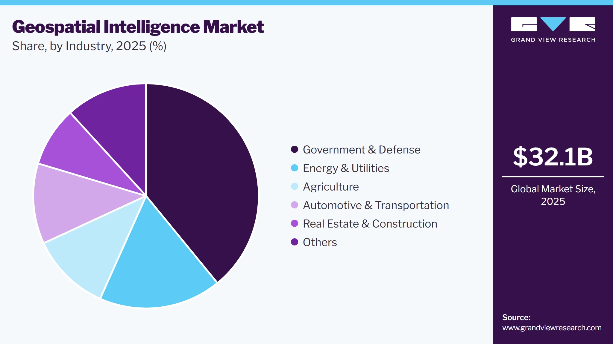
The automotive & transportation segment is expected to witness significant growth in the Geospatial Intelligence Market, driven by increasing adoption of location intelligence for route optimization, fleet management, traffic monitoring, infrastructure planning, and connected mobility applications. Geospatial intelligence enables transportation operators and automotive companies to analyze real-time traffic conditions, road networks, vehicle locations, travel patterns, and infrastructure data to improve operational efficiency and mobility planning.
Regional Insights
North America geospatial intelligence market dominates the global market, supported by substantial investments in defense and national security, advanced Earth-observation capabilities, and widespread adoption of geospatial analytics technologies. The region, led by the United States, benefits from the presence of major geospatial technology providers, satellite operators, defense contractors, intelligence agencies, and established space and remote-sensing infrastructure. Increasing investments in high-resolution satellite imagery, synthetic aperture radar (SAR), UAV-based intelligence, GIS platforms, AI-enabled geospatial analytics, and real-time data-fusion technologies are strengthening the region’s GEOINT capabilities.
U.S. Geospatial Intelligence Market Trends
Geospatial intelligence market in the U.S. is growing due to increasing investments in national security, defense intelligence, satellite-based Earth observation, and advanced geospatial analytics. The country benefits from a well-established space and defense ecosystem, extensive satellite infrastructure, leading GEOINT technology providers, and strong government demand for intelligence, surveillance, and reconnaissance (ISR) capabilities. Increasing adoption of high-resolution satellite imagery, synthetic aperture radar (SAR), UAV-based sensing, GIS platforms, and real-time geospatial analytics is strengthening the country’s ability to support situational awareness, mission planning, border monitoring, and threat assessment.
Europe Geospatial Intelligence Market Trends
Geospatial intelligence market in Europe is witnessing steady growth, driven by increasing investments in satellite imagery, Earth observation, defense intelligence, and advanced geospatial analytics. European countries are strengthening their GEOINT capabilities through the development and deployment of satellite constellations, high-resolution imagery systems, remote sensing technologies, GIS platforms, and AI-enabled geospatial solutions. Increasing requirements for defense and border security, intelligence, surveillance and reconnaissance, environmental monitoring, urban planning, and disaster management are further supporting demand for Geospatial Intelligence across the region
Geospatial intelligence market in the UK is strengthening its GEOINT capabilities through increasing adoption of satellite imagery, remote sensing, GIS platforms, geospatial analytics, and real-time intelligence for defense, surveillance, border security, critical infrastructure monitoring, and strategic planning. Growing demand for location-based analytics across urban planning, environmental monitoring, logistics, and commercial applications is further supporting market expansion.
Germany geospatial intelligence market is experiencing significant growth, supported by increasing investments in digital transformation, defense and national security, satellite-based Earth observation, and advanced geospatial technologies. Germany is strengthening its GEOINT capabilities through investments in satellite imagery, remote sensing, GIS platforms, AI-enabled geospatial analytics, real-time location intelligence, and multi-source data integration to support defense, critical infrastructure monitoring, logistics, urban planning, and environmental applications.
Asia-Pacific Geospatial Intelligence Market Trends
The geospatial intelligence market in APAC is witnessing the fastest CAGR of 13.4% over the forecast period, driven by increasing investments in satellite technology, Earth observation, digital infrastructure, smart-city development, and advanced geospatial analytics across China, India, Japan, South Korea, and Australia. Governments across the region are strengthening their GEOINT capabilities through investments in satellite imagery, remote sensing, GIS platforms, UAV-based sensing, AI-enabled analytics, and real-time geospatial intelligence to support defense, infrastructure development, disaster management, environmental monitoring, and urban planning.
China Geospatial Intelligence Market is experiencing growth due tothe growing integration of AI, machine learning, cloud computing, 5G, and multi-source geospatial data is improving the processing and analysis of large volumes of satellite and location-based information. At the same time, rapid urbanization, smart-city initiatives, autonomous transportation, precision agriculture, and environmental monitoring are creating additional opportunities for GEOINT adoption, supporting China's position as a key growth market in the Asia-Pacific region.
Key Geospatial Intelligence Company Insights
The geospatial intelligence market is characterized by the presence of established aerospace and defense, satellite, geospatial technology, and intelligence companies with strong capabilities across Earth observation, satellite imagery, remote sensing, GIS, geospatial analytics, AI-enabled intelligence, data fusion, and GEOINT services. Competition is driven by continuous innovation in high-resolution imagery, satellite constellations, synthetic aperture radar (SAR), UAV-based sensing, AI and machine learning, real-time geospatial analytics, cloud-based platforms, and automated imagery interpretation. Established players maintain strong market positions through extensive R&D capabilities, proprietary geospatial technologies, government and defense contracts, satellite programs, strategic partnerships, data licensing agreements, and long-term intelligence and analytics services.
-
Esri is a leading player in the Geospatial Intelligence Market, providing GIS software, spatial analytics, mapping, geovisualization, and location-intelligence platforms. Its ArcGIS ecosystem enables government, defense, infrastructure, transportation, environmental, and commercial organizations to integrate and analyze geospatial data for mapping, situational awareness, asset monitoring, and decision-making
-
Maxar Technologies / Vantor is a major provider of high-resolution Earth-observation imagery and geospatial intelligence solutions, supporting defense, intelligence, mapping, infrastructure monitoring, and commercial applications. Its capabilities in satellite imagery, Earth intelligence, and AI-enabled geospatial analytics position the company as a key provider of commercial GEOINT data and intelligence solutions.
Key Geospatial Intelligence Companies
The following key companies have been profiled for this study on the geospatial intelligence market.
-
Esri
-
Maxar Technologies / Vantor
-
Planet Labs PBC
-
Hexagon AB
-
L3Harris Technologies, Inc.
-
BlackSky Technology Inc.
-
ICEYE
-
Palantir Technologies Inc.
Competitive Benchmarking
Category
Operating Strategies
Competitive Edge
Weakness
Mature Players: Esri; Maxar Technologies / Vantor; Hexagon AB; L3Harris Technologies, Inc.; Palantir Technologies Inc.
- • Invest in GIS, satellite imagery, Earth observation, remote sensing, AI-enabled geospatial analytics, cloud platforms, and multi-source data fusion.
- • Expand capabilities through government and defense contracts, strategic partnerships, acquisitions, technology integration, data licensing, and long-term customer agreements.
- • Develop solutions for ISR, asset monitoring, risk assessment, infrastructure management, disaster response, environmental monitoring, and urban planning.
- • Strong geospatial technology and analytics capabilities.
- • Extensive R&D and AI, GIS, satellite, imagery, and data-processing expertise.
- • Established relationships with government, defense, and enterprise customers.
- • High R&D and technology-development costs.
- • Dependence on government and defense contracts for several GEOINT applications.
- • Complex integration of imagery, GIS, sensor, and non-imagery datasets.
Emerging Players: Planet Labs PBC; BlackSky Technology Inc.; ICEYE
- • Focus on expanding commercial satellite constellations, Earth-observation capabilities, SAR, real-time monitoring, and AI-powered geospatial intelligence platforms.
- • Invest in high-revisit satellite imaging, automated imagery analysis, cloud-based data delivery, and near-real-time intelligence capabilities.
- • Specialized capabilities in high-frequency Earth observation, SAR, real-time GEOINT, and automated geospatial analytics.
- • Agile technology development and faster innovation cycles.
- • Growing presence in commercial and government GEOINT applications.
- • Smaller installed base and global footprint compared with mature players.
- • High capital requirements for satellite constellation development and maintenance.
Recent Development
-
In July 2026, Esri introduced new geospatial foundation models in ArcGIS, expanding its GeoAI capabilities for analyzing maps, satellite imagery, demographic information, and other geographic datasets. The models are designed to support workflows including similarity search, predictive modeling, feature extraction, and natural-language interaction with geospatial imagery, strengthening Esri’s position in AI-enabled Geospatial Intelligence.
-
In June 2026, Palantir Technologies Inc. expanded its geospatial capabilities within its Foundry platform, introducing more than 25 built-in GeoExpressions in Pipeline Builder for cleaning, transforming, and visualizing geospatial data. The capabilities include geometry intersections, GeoJSON parsing, GeoPoint conversions, and other geospatial operations, strengthening the platform’s ability to integrate geospatial analytics with broader operational intelligence workflows
Geospatial Intelligence Market Report Scope
Report Attribute
Details
Market size value in 2025
USD 32.1 billion
Estimated market size in 2026
USD 35.7 billion
Projected market size by 2033
USD 81.0 billion
Growth rate
CAGR of 12.4% from 2026 to 2033
Actual data
2021 - 2025
Forecast period
2026- 2033
Quantitative units
Revenue in USD billion and CAGR from 2026 to 2033
Report coverage
Revenue forecast, company ranking, competitive landscape, growth factors, and trends
Segments covered
Component, technology, application, industry, region
Regional scope
North America; Europe; Asia Pacific; Latin America; MEA
Country scope
U.S.; Canada; Mexico; Germany; UK; France; China; India; Japan; Australia; South Korea; Brazil; UAE; South Africa; KSA
Key companies profiled
Esri; Maxar Technologies / Vantor; Hexagon AB; L3Harris Technologies, Inc.; Palantir Technologies Inc.; Planet Labs PBC; BlackSky Technology Inc.; ICEYE
Customization scope
Free report customization (equivalent up to 8 analysts working days) with purchase. Addition or alteration to country, regional & segment scope.
Pricing and purchase options
Avail customized purchase options to meet your exact research needs. Explore purchase options
Global Geospatial Intelligence Market Report Segmentation
This report forecasts revenue growth at global, regional, and country levels and provides an analysis of the latest industry trends in each of the sub-segments from 2021 to 2033. For this study, Grand View Research has segmented the global geospatial intelligence market report based on component, technology, application, industry, and region:
-
Component Outlook (Revenue, USD Billion, 2021 - 2033)
-
Software
-
Geospatial Acquisition Systems
-
Services
-
-
Technology Outlook (Revenue, USD Billion, 2021 - 2033)
-
Vector & GIS Analytics
-
Raster & Imagery Analytics
-
Streaming & Real-time Analytics
-
Geo-visualization
-
-
Application Outlook (Revenue, USD Billion, 2021 - 2033)
-
Asset Monitoring & Management
-
Risk Assessment & Modeling
-
Disaster Management & Response
-
Urban Planning & Digital Twins
-
Surveillance & Security
-
Others
-
-
Industry Outlook (Revenue, USD Billion, 2021 - 2033)
-
Government & Defense
-
Energy & Utilities
-
Automotive & Transportation
-
Real Estate & Construction
-
Agriculture
-
Others
-
-
Regional Outlook (Revenue, USD Billion, 2021 - 2033)
-
North America
-
U.S.
-
Canada
-
Mexico
-
-
Europe
-
UK
-
Germany
-
France
-
-
Asia Pacific
-
China
-
Japan
-
India
-
Australia
-
South Korea
-
-
Latin America
-
Brazil
-
-
Middle East and Africa (MEA)
-
KSA
-
UAE
-
South Africa
-
-
Research Methodology
The geospatial intelligence market figures in this report are based on a proven research process that combines executive interviews with secondary research from proprietary databases, company filings, and recognized regulatory and institutional sources. Market size is built through value-chain sizing-reconciling supply-side and demand-side estimates-and triangulated with bottom-up and top-down approaches. Every estimate passes multiple levels of expert validation before publication, with each geospatial intelligence segment quantified using the revenue-capture definitions in the table below.
Segment Definition
Segment - Component
Revenue capture definition
Software
Software revenue in the Geospatial Intelligence Market is generated through the sale and licensing of GIS platforms, geospatial analytics software, imagery-processing solutions, remote-sensing applications, GeoAI platforms, spatial intelligence tools, and cloud-based geospatial software.
Geospatial Acquisition Systems
Revenue from Geospatial Acquisition Systems in the Geospatial Intelligence Market is generated through the sale and deployment of systems used to collect, capture, and acquire geospatial information from physical and remote environments.
Services
Services revenue in the Geospatial Intelligence Market is generated through the provision of geospatial data acquisition, processing, analysis, interpretation, consulting, system integration, and managed GEOINT services.
Segment - Technology
Revenue capture definition
Vector & GIS Analytics
Revenue from Vector & GIS Analytics in the Geospatial Intelligence Market is generated through the sale and licensing of GIS platforms, vector-based mapping software, spatial databases, and spatial analytics solutions used to process, analyze, and visualize location-based data. These solutions support asset monitoring, risk assessment, urban planning, defense intelligence, environmental monitoring, and route optimization, with revenue generated through licenses, subscriptions, cloud platforms, and related integration services.
Raster & Imagery Analytics
Revenue from Raster & Imagery Analytics in the Geospatial Intelligence Market is generated through the sale and licensing of satellite imagery, remote-sensing software, image-processing platforms, and raster analytics solutions used to process and interpret visual geospatial data. These solutions support ISR, surveillance, asset monitoring, environmental monitoring, disaster response, and risk assessment, with revenue generated through software licenses, subscriptions, imagery access, analytics platforms, and related services.
Streaming & Real-time Analytics
Revenue from Streaming & Real-time Analytics in the Geospatial Intelligence Market is generated through real-time geospatial processing platforms, location-data streaming solutions, and analytics tools used to monitor and analyze continuously changing geographic data. These solutions support real-time surveillance, asset tracking, traffic monitoring, disaster response, security, and operational intelligence, with revenue generated through software licenses, subscriptions, cloud platforms, and analytics services.
Geovisualization
Revenue from Geovisualization in the Geospatial Intelligence Market is generated through 3D mapping, interactive visualization platforms, spatial dashboards, and geospatial visualization software used to display and interpret complex geographic information. These solutions support situational awareness, urban planning, asset monitoring, defense intelligence, infrastructure management, and environmental monitoring, with revenue generated through software licenses, subscriptions, cloud platforms, and visualization services.
Segment - Application
Revenue capture definition
Asset Monitoring & Management
Revenue from Asset Monitoring & Management in the Geospatial Intelligence Market is generated through geospatial monitoring platforms, location intelligence solutions, satellite imagery, and spatial analytics services used to track, assess, and manage physical assets and infrastructure. These solutions support asset tracking, condition monitoring, maintenance planning, infrastructure management, and change detection, with revenue generated through software subscriptions, data services, analytics platforms, and managed services.
Risk Assessment & Modeling
Revenue from Risk Assessment & Modeling in the Geospatial Intelligence Market is generated through geospatial risk analytics, predictive modeling platforms, satellite imagery, and spatial data solutions used to identify and assess geographic, environmental, security, and operational risks. These solutions support hazard mapping, vulnerability assessment, disaster-risk analysis, and predictive planning, with revenue generated through software licenses, subscriptions, data services, and analytics solutions.
Disaster Management & Response
Revenue from Disaster Management & Response in the Geospatial Intelligence Market is generated through satellite imagery, geospatial analytics platforms, mapping solutions, and real-time monitoring services used to assess disasters and support emergency response. These solutions enable damage assessment, hazard mapping, emergency planning, resource allocation, and real-time situational awareness, with revenue generated through software, imagery data, analytics, and related services
Urban Planning & Digital Twins
Revenue from Urban Planning & Digital Twins in the Geospatial Intelligence Market is generated through 3D geospatial platforms, digital twin solutions, GIS software, and spatial analytics used to model and manage urban environments. These solutions support city planning, infrastructure development, traffic management, asset management, and scenario analysis, with revenue generated through software licenses, subscriptions, cloud platforms, and implementation services.
Surveillance & Security
Revenue from Surveillance & Security in the Geospatial Intelligence Market is generated through satellite imagery, geospatial analytics, remote-sensing platforms, and real-time monitoring solutions used for security and situational awareness. These solutions support border monitoring, threat detection, ISR, critical infrastructure protection, and security operations, with revenue generated through software, imagery data, analytics platforms, and related services.
Others
Revenue from Other Applications in the Geospatial Intelligence Market is generated through geospatial data, mapping solutions, analytics platforms, and intelligence services supporting applications such as precision agriculture, supply-chain optimization, environmental monitoring, climate analysis, and telecommunications planning. Revenue is generated through software licenses, data subscriptions, analytics solutions, and related geospatial services.
Segment - Industry
Revenue capture definition
Government & Defense
Revenue from Government & Defense in the Geospatial Intelligence Market is generated through the provision of satellite imagery, GIS platforms, remote-sensing systems, geospatial analytics, and GEOINT services for government and defense applications. These solutions support ISR, surveillance, border security, mission planning, threat assessment, and situational awareness, with revenue generated through software, data products, systems, analytics, and long-term government contracts.
Energy & Utilities
Revenue from Energy & Utilities in the Geospatial Intelligence Market is generated through GIS platforms, satellite imagery, remote sensing, and geospatial analytics used to monitor and manage energy assets and utility infrastructure. These solutions support pipeline and grid monitoring, asset management, site selection, infrastructure planning, and environmental assessment, with revenue generated through software subscriptions, data services, analytics platforms, and consulting services.
Automotive & Transportation
Revenue from Automotive & Transportation in the Geospatial Intelligence Market is generated through GIS platforms, real-time location intelligence, mapping solutions, satellite data, and geospatial analytics used to optimize transportation and mobility operations. These solutions support route optimization, fleet tracking, traffic management, infrastructure planning, navigation, and connected mobility, with revenue generated through software licenses, subscriptions, data services, and analytics solutions.
Real Estate & Construction
Revenue from Real Estate & Construction in the Geospatial Intelligence Market is generated through GIS platforms, satellite imagery, 3D mapping, geospatial analytics, and digital twin solutions used for site assessment, property analysis, infrastructure planning, and construction monitoring. These solutions support site selection, land-use analysis, project planning, asset monitoring, and development management, with revenue generated through software subscriptions, data services, analytics platforms, and consulting services.
Agriculture
Revenue from Agriculture in the Geospatial Intelligence Market is generated through satellite imagery, remote sensing, GIS platforms, and geospatial analytics used to monitor and optimize agricultural activities. These solutions support crop monitoring, soil analysis, yield forecasting, irrigation management, precision farming, and agricultural risk assessment, with revenue generated through software subscriptions, imagery data, analytics platforms, and related services.
Others
Revenue from Other Verticals in the Geospatial Intelligence Market is generated through geospatial data, GIS platforms, satellite imagery, and analytics solutions used across sectors such as telecommunications, insurance and financial services, healthcare, life sciences, mining, and other commercial applications.
Estimation Model
Layer Name
Key Question
Description
Addressable Geospatial Intelligence Base Layer
Which geospatial intelligence technologies, data sources, and platforms are currently deployed or addressable?
Estimate the global addressable base of GEOINT software, geospatial acquisition systems, satellite and aerial imagery, remote sensing technologies, GIS platforms, geospatial analytics, and intelligence services. The assessment considers installed platforms, data availability, technology adoption, replacement cycles, government and commercial requirements, and regional geospatial infrastructure.
Geospatial Intelligence Adoption Layer
Which types of geospatial intelligence technologies and capabilities are deployed?
Apply adoption and deployment rates across software, geospatial acquisition systems, and services, considering the use of GIS analytics, imagery analytics, real-time analytics, geovisualization, satellite imagery, remote sensing, AI-enabled analytics, and multi-source data fusion across major applications.
Technology & Solution Configuration Layer
What technologies and capabilities are incorporated into each GEOINT solution?
Estimate solution value based on the integration of GIS and vector analytics, raster and imagery analytics, streaming and real-time analytics, geovisualization, satellite and sensor data, AI/ML, cloud computing, data fusion, and geospatial processing capabilities.
Revenue Generation Layer
How is revenue generated from Geospatial Intelligence solutions?
Estimate market revenue from software licenses and subscriptions, geospatial data and imagery, acquisition systems, analytics platforms, consulting, system integration, managed services, cloud-based GEOINT platforms, and recurring data or intelligence services.
Delivered Customization
We have successfully delivered the following deep-dive customizations:
Client Request
Customization Delivered
Value Adds
Geospatial Intelligence Market Entry & Growth Strategy
Assessment of demand for GEOINT across Government & Defense, Energy & Utilities, Automotive & Transportation, Real Estate & Construction, Agriculture, and other verticals.
Analysis of opportunities across GEOINT software, geospatial acquisition systems, services, satellite imagery, GIS analytics, real-time analytics, and geovisualization.
Identified high-growth technology, application, vertical, and regional segments.
Supported market entry, product positioning, customer targeting, partnership identification, and expansion strategies.
Next-Generation Geospatial Intelligence & Capability Assessment
Evaluation of GEOINT capability requirements across defense and intelligence, government, infrastructure, transportation, agriculture, disaster management, and environmental applications.
Assessment of next-generation requirements related to AI/ML, satellite imagery, SAR, real-time analytics, cloud computing, multi-source data fusion, and digital twin
Identified technology gaps and high-potential innovation areas within the GEOINT ecosystem.
Supported technology roadmap development, R&D prioritization, solution enhancement, and next-generation GEOINT platform strategies.
About the Author(s)
Next Generation Technologies Research Team
Technology · Next Generation TechnologiesThis report was authored by the next generation technologies research team at Grand View Research - comprising two research analysts, one senior research analyst, and one industry expert - with specialized expertise in the next generation technologies segment of the technology industry. All findings are based on proprietary technology databases, executive interviews, and regulatory analysis, subject to internal peer review prior to publication.
Last Updated:
Speak to Analyst


Customize this report to your needs - add regions, segments, or data points, with 20% free customization.
Or view our licence options:


ISO 9001:2015 & 27001:2022 Certified
We are GDPR and CCPA compliant! Your transaction & personal information is safe and secure. For more details, please read our privacy policy.


