
- Home
- »
- HVAC & Construction
- »
-
Land Survey Equipment Market Size Report, 2026-2033GVR Report cover

Land Survey Equipment Market (2026 - 2033)
Size, Share & Trends Analysis Report By Component (Hardware, Software), By Application (Inspection, Monitoring), By End-use (Commercial, Defense), By Industry (Transportation, Energy & Power, Agriculture), By Region, And Segment Forecasts
Market Size, 2025
$10.1BMarket Estimate, 2026
$10.6BMarket Forecast, 2033
$16.4BCAGR, 2026–2033
6.4%Land Survey Equipment Market Summary
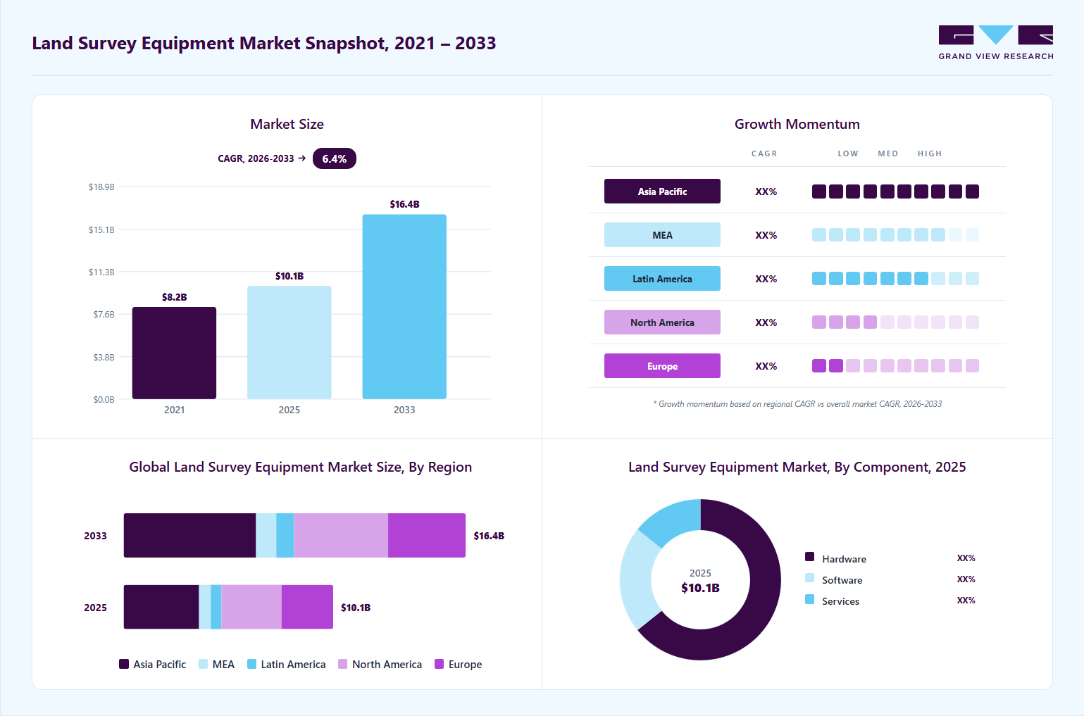
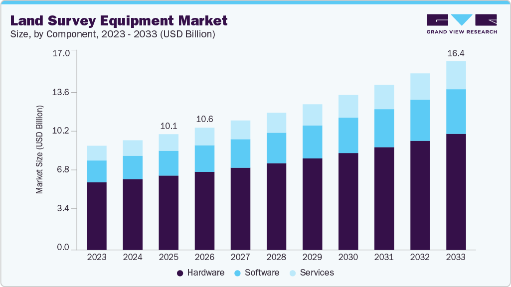
The global land survey equipment market size was valued at USD 10.1 billion in 2025 and is projected to grow from USD 10.6 billion in 2026 to USD 16.4 billion by 2033, at a CAGR of 6.4% from 2026 to 2033. The market in Asia Pacific dominated with a revenue share of 35.9% in 2025. The global surge in construction and infrastructure projects is driving the growth of the market.
 Source: Grand View Research, IR Documents, Primary Interviews, Paid DatabasesTo learn more about this report,
 Download Free Sample Report
Key Market Trends & Insights
- By component: Hardware segment held the largest market share of 64.3% in 2025.
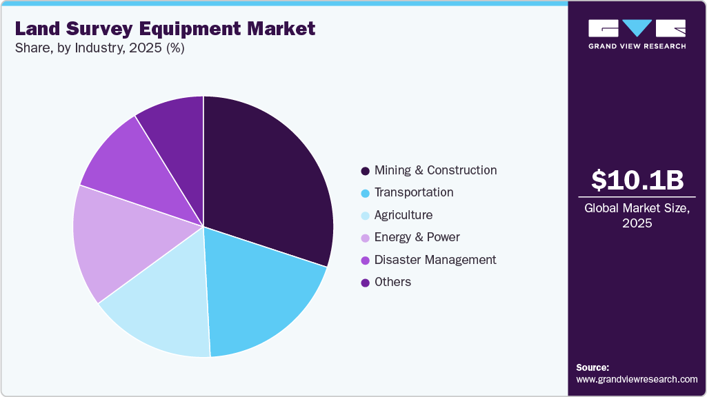
- By industry: Mining & construction segment held the largest market share of 30.0% in 2025.
- By application: Inspection segment held the largest market share of 24.7% in 2025.
- By end-use: Commercial segment held the largest market share in 2025.
Regional Highlights
- Largest regional market: Asia Pacific (35.9% revenue share, 2025)
- By country: China held the largest market share in 2025
Market Size & Forecast
- Market size in 2025: USD 10.1 Billion
- Estimated market size in 2026: USD 10.6 Billion
- Projected market size by 2033: USD 16.4 Billion
- CAGR (2026-2033): 6.4%
Three ways to get this report
Buy it, customize it, or ask a question.Ask an Analyst
Analyst response in 1 business day
- AccessReport author, directly
- Reply timeWithin 1 working day
- No sales callDirect answer only
- FormatEmail reply
- CostFree, no cost
Get the Full Report
What the study covers
- FormatsPDF · Excel · Dashboard
- Timeline2026–2033 annual, 2025 base
- Coverage20+ countries, 5 regions
- Companies10+ key players profiled
Customize the Report
20% free customization
- IncludeCountries, segments, points
- TailorTo your product definition
- ExtendDeeper competitor detail
- OrA fully bespoke study
- Turnaround5–10 working days
Governments and private sectors are investing heavily in the development of roads, bridges, airports, and other public utilities. Accurate land surveys are essential for these projects to ensure proper planning, design, and execution. Surveying equipment such as GNSS systems and total stations plays a critical role in providing precise measurements and geospatial data. The increasing complexity of modern infrastructure demands high-quality surveying tools, leading to sustained growth in this market.Technological innovations in the field of land surveying have significantly enhanced the accuracy and efficiency of survey processes. Advanced GNSS systems provide real-time, high-precision positioning, which is crucial for many surveying applications. The advent of drones has revolutionized aerial surveying by offering faster data collection over large areas with minimal human intervention. Laser scanning technology enables detailed 3D mapping of terrain and structures, facilitating better analysis and decision-making. These technological advancements are making land surveying more effective and less time-consuming, driving the adoption of modern surveying equipment.
 To learn more about this report, Download Free Sample Report
Rapid urbanization significantly fuels the demand for land survey equipment as expanding cities and newly developed urban areas require continuous and precise land assessments. Detailed surveying is essential to support planning, infrastructure development, and efficient land utilization. Urban planners and developers depend on accurate geospatial data to design optimized layouts, transportation networks, and utilities. Ongoing monitoring through frequent land surveys is also necessary to track changes and ensure adherence to zoning laws and environmental regulations. Strong urban growth trends, particularly in emerging economies, continue to generate sustained demand and drive the expansion of the land survey equipment market.
Precise land surveys are crucial for accurately resolving property disputes and clearly establishing legal boundaries. These surveys provide detailed, accurate measurements of land, which help determine the true extent and limits of property ownership. Accurate surveys prevent encroachments and ensure that all parties have a clear understanding of their property lines, reducing the potential for conflicts. They also serve as legal documents that can be used in court to support claims and settle disagreements. Furthermore, precise land surveys are essential for proper land development, urban planning, and infrastructure projects, ensuring that all constructions and developments adhere to legal and regulatory standards.
Market Dynamics
The growing adoption of digital construction and building information modeling (BIM) is contributing to demand for advanced land survey equipment. Construction companies increasingly rely on precise geospatial data to support digital twins, automated machine guidance, and project lifecycle management. Surveying instruments integrated with GIS and BIM platforms help engineers improve project planning, reduce rework, and optimize resource utilization. In mining, oil & gas, agriculture, and utilities, survey equipment is also being used for terrain analysis, asset monitoring, and environmental assessment, expanding the application scope beyond conventional land measurement activities.
High capital investment requirements are restraining the growth of the land survey equipment market. Advanced surveying instruments, such as GNSS receivers, robotic total stations, LiDAR scanners, and UAV-based systems, involve substantial upfront costs, making them less accessible to small and medium-sized surveying firms. Beyond the initial purchase, companies must also bear recurring expenses for software licensing, equipment maintenance, calibration, training, and periodic technological upgrades. These cumulative costs significantly increase the total cost of ownership, particularly for firms operating in price-sensitive or developing markets. Budget constraints often force organizations to delay modernization or continue using conventional surveying methods, which in turn slows the overall adoption of advanced digital surveying technologies and limits market expansion.
Emerging smart city and infrastructure megaprojects offer growth opportunities for the land survey equipment market. Governments across developed and developing regions are investing in smart transportation systems, urban mobility, high-speed rail, renewable energy installations, and large-scale urban planning initiatives. These projects require highly accurate geospatial data for planning, design, and execution, creating sustained demand for advanced surveying tools. Survey equipment integrated with real-time positioning and digital modeling capabilities plays a critical role in enabling efficient project delivery, making it an essential component of next-generation infrastructure development.
Market Concentration & Characteristics
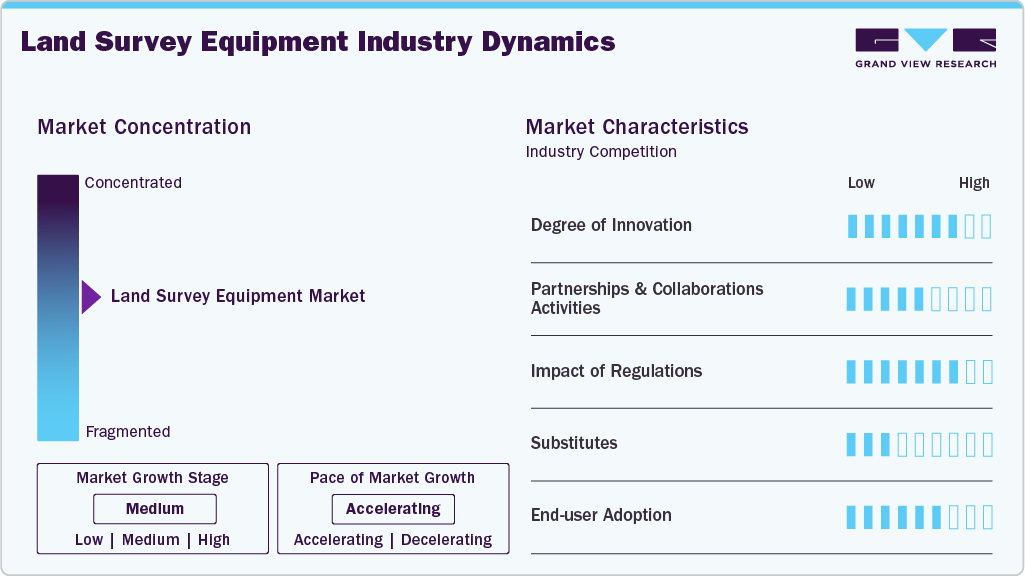
The land survey equipment market is generally considered moderately consolidated due to the strong presence of a limited number of global companies that dominate the high-precision surveying and geospatial technology segments. Major players such as Trimble, Hexagon AB, and Topcon Corporation hold significant market shares through their extensive product portfolios, advanced GNSS systems, total stations, LiDAR technologies, and integrated software platforms. These companies benefit from strong global distribution networks, continuous R&D investments, strategic acquisitions, and long-term contracts with construction, mining, infrastructure, and government surveying agencies.
 To learn more about this report, Download Free Sample Report
At the same time, the market is not fully consolidated because several regional and emerging manufacturers compete aggressively in cost-sensitive and mid-tier equipment categories. Companies such as Hi-Target and Stonex are expanding their presence by offering competitively priced surveying solutions with increasingly advanced technological capabilities. The growing adoption of UAV-based surveying, mobile mapping systems, and digital construction technologies has also enabled new entrants and niche players to enter specific application areas. As a result, while leading multinational companies maintain dominance in premium and technologically advanced solutions, the presence of multiple regional competitors keeps the market moderately consolidated rather than highly concentrated.
Component Insights
Based on component, the hardware segment led the market and accounted for 64.3% of the global revenue in 2025. The growth of the segment can be attributed to the continuous advancements in technology, enhancing the precision and reliability of surveying tools. Innovations in GNSS systems, total stations, and drones are providing more accurate and efficient data collection, making them indispensable for modern surveying tasks. The demand for robust and durable hardware is rising, especially for use in challenging environments such as construction sites and remote agricultural fields. In addition, the integration of advanced sensors and improved battery life in these devices is further boosting their adoption across various industries.
The software segment is expected to grow at the fastest CAGR over the forecast period. The increasing need for advanced data processing and analysis is contributing to the growth of the segment. Modern survey software offers sophisticated features for 3D modeling, geospatial analysis, and data integration, which are essential for accurate and comprehensive land surveys. The trend towards digitalization and the use of cloud-based platforms are making it easier for surveyors to store, share, and access data in real-time, enhancing collaboration and efficiency. Furthermore, the development of user-friendly interfaces and automated workflows is simplifying complex surveying tasks, driving the adoption of advanced software solutions in the market.
Application Insights
The inspection segment accounted for the largest market revenue share in 2025. The expansion of energy and utility networks is accelerating the adoption of survey equipment for inspection. Power lines, pipelines, wind farms, and solar installations require continuous monitoring to detect faults, encroachments, and environmental risks. Survey technologies, particularly drone-based and LiDAR-enabled systems, enable operators to inspect large, remote assets quickly and safely. These tools reduce the need for manual inspections in hazardous environments while improving data accuracy and coverage, making them highly valuable across the energy and utilities sector.
The monitoring segment is expected to grow the fastest CAGR from 2026 to 2033. The monitoring segment is gaining traction due to the growing need for continuous observation and analysis of land and structural changes. Infrastructure projects, especially in urban areas, require ongoing monitoring to ensure stability and safety. Advanced survey equipment, such as laser scanners and drones, provides high-resolution data for real-time monitoring of shifts, deformations, and environmental impacts. In addition, the increasing emphasis on disaster preparedness and environmental conservation is driving the demand for monitoring solutions that can provide timely and accurate data to mitigate risks and manage resources effectively.
End-use Insights
The commercial segment accounted for the largest market revenue share in 2025. The increasing demand for accurate and efficient surveying solutions across various industries, such as construction, agriculture, and mining, is contributing to the growth of the market. Businesses are investing in advanced survey equipment to enhance precision in project planning and execution, thereby reducing costs and improving outcomes. The adoption of technologies such as GNSS systems, drones, and laser scanners is enabling commercial enterprises to undertake complex surveying tasks with greater ease and accuracy. In addition, the integration of these tools with digital platforms for data management and analysis is further boosting their utility and appeal in the commercial sector.
The service providers segment is expected to grow significantly from 2026 to 2033. The service providers segment is experiencing growth due to the rising need for specialized surveying services across different sectors. Companies offering surveying services are increasingly relying on advanced equipment to deliver precise and reliable results to their clients. The trend towards outsourcing surveying tasks to expert service providers is driven by the need for high-quality data and the expertise required to operate advanced equipment. Furthermore, service providers are leveraging the latest software solutions to enhance data processing, visualization, and reporting, thereby offering customers comprehensive, value-added services.
Industry Insights
The mining & construction segment accounted for the largest market revenue share in 2025. The growing need for precision and efficiency in large-scale projects is driving the growth of the segment. Advanced surveying tools such as GNSS system and laser scanners are essential for accurate site measurements, layout planning, and monitoring structural integrity. The increasing complexity of mining operations and construction projects demands high-precision equipment to ensure safety, compliance, and optimal resource utilization. Furthermore, technological advancements such as automated workflows and real-time data integration are enhancing the productivity and accuracy of surveying tasks in these industries.
 To learn more about this report, Download Free Sample Report
The agriculture segment is expected to grow at the fastest CAGR over the forecast period. In the agriculture segment, the demand for land survey equipment is driven by the growing adoption of precision farming techniques. Accurate land surveys are crucial for optimizing field layouts, planning irrigation systems, and managing crop health. Advanced tools such as GNSS systems and drones are used to gather detailed geospatial data, helping farmers make informed decisions to enhance yields and efficiency. In addition, the push towards sustainable farming practices is increasing the need for precise land measurements to ensure efficient resource use and minimize environmental impact.
Regional Insights
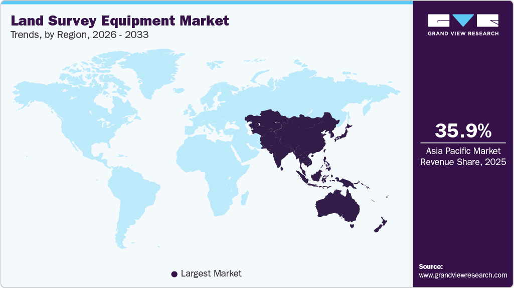
Theland survey equipment market in the Asia Pacificdominated the global market and accounted for 35.9% in 2025. The rapid pace of urbanization in the region is driving demand for land surveying services. Rising infrastructure projects, particularly in China and India, are propelling the need for advanced surveying technologies. In addition, growing investments in smart city initiatives across Southeast Asia are further boosting demand.
 To learn more about this report, Download Free Sample Report
China Land Survey Equipment Market Trends
The China land survey equipment market held a dominant share in the Asia Pacific, supported by extensive infrastructure development and urban expansion initiatives. The country’s focus on large-scale projects such as high-speed rail networks, smart cities, and industrial zones drives substantial demand for surveying technologies.
The land survey equipment market in India presents significant growth potential, driven by rapid urbanization, infrastructure development, and government-led initiatives such as Smart Cities Mission and Digital India. Increasing investments in transportation, real estate, and utility sectors are generating demand for accurate land measurement and mapping solutions.
North AmericaLand Survey Equipment Market Trends
The North America land survey equipment market is anticipated to register significant growth from 2026 to 2033. In North America, the market is driven by ongoing advancements in technology and a robust demand for high-precision surveying tools. The region's focus on infrastructure modernization and urban development necessitates the adoption of cutting-edge equipment.
The land survey equipment market in the U.S. is anticipated to register significant growth from 2026 to 2033. The growth in the country is supported by sustained investments in infrastructure modernization, transportation networks, and renewable energy projects. Federal and state-level initiatives to rebuild aging infrastructure continue to drive strong demand for high-precision surveying solutions.
Europe Land Survey Equipment Market Trends
The land survey equipment market in Europe is poised for significant growth from 2026 to 2033. The growth in the region is by stringent regulatory frameworks, infrastructure upgrades, and smart city initiatives. The region places strong emphasis on environmental monitoring, sustainable urban planning, and digital construction practices, which increases the demand for high-accuracy geospatial data.
The UK land survey equipment market is characterized by increasing investments in infrastructure development, including rail modernization, urban redevelopment, and energy transition projects. Demand for land survey equipment is supported by the growing adoption of digital construction methodologies such as BIM and digital twin technologies.
The land survey equipment market in Germany is a technologically advanced and highly regulated market for land survey equipment, driven by strong industrial and infrastructure development. The country’s focus on precision engineering and digitalization supports the adoption of high-end surveying instruments and integrated geospatial solutions.
Key Land Survey Equipment Company Insights
Key players operating in the land survey equipment market include STONEX Srl, Trimble Inc., Hexagon AB, Shanghai Huace Navigation Technology Ltd., GUANGDONG KOLIDA INSTRUMENT CO., LTD., VI Instruments, Hi-Target, SUZHOU FOIF CO LTD., TOPCON CORPORATION. These companies are focusing on advancing technology and expanding their product portfolios to capture a significant share of the growing demand. Key players are also investing heavily in innovation to enhance the precision and efficiency of their equipment, incorporating features such as GPS integration, 3D scanning, and advanced data analytics.
-
STONEX Srl is a geospatial technology company known for high-precision measurement, surveying, GNSS positioning, sensors, scanners, and 3D data-acquisition solutions. It serves architecture, engineering, and construction, topographic surveying, machine control, and broader infrastructure applications through a global distribution network of 200+ partners, with an emphasis on accuracy, reliability, and easy-to-use products.
-
Trimble Inc. is a technology company that connects the physical and digital worlds through positioning, modeling, connectivity, and data analytics solutions. It serves essential industries such as construction, geospatial, agriculture, transportation, and logistics with hardware, software, and cloud services that help customers measure, build, grow, and move goods more efficiently and safely. The company is especially known for its GNSS receivers, optical instruments, machine guidance systems, 3D modeling tools, and enterprise software used across the project lifecycle.
Key Land Survey Equipment Companies:
The following key companies have been profiled for this study on the land survey equipment market.
- STONEX Srl,
- Trimble Inc.
- Hexagon AB
- Shanghai Huace Navigation Technology Ltd.
- GUANGDONG KOLIDA INSTRUMENT CO., LTD.
- VI Instruments
- Hi-Target
- SUZHOU FOIF CO LTD.
- TOPCON CORPORATION
- Autodesk Inc.
Competitive Benchmarking
Operating Strategies
Competitive Edge
Weaknesses
Mature Players: Hexagon AB; TOPCON CORPORATION; Trimble Inc.; Autodesk Inc.
- Mature players in the land survey equipment market focus on expanding integrated geospatial and digital surveying ecosystems by combining GNSS technologies, LiDAR, GIS software, AI-enabled analytics, and cloud-based data management platforms.
- Mature players gain a competitive advantage through strong global distribution networks, advanced positioning technologies, extensive software integration capabilities, and established brand recognition.
- Their ability to provide end-to-end surveying solutions, including total stations, laser scanners, UAV mapping systems, and geospatial software, enables them to maintain leadership in large-scale infrastructure.
- These companies often face challenges related to high equipment costs, complex system integration, and slower adaptation to low-cost market segments.
- Their large operational structures and premium pricing strategies can limit penetration in price-sensitive emerging markets. At the same time, rapid advancements in drone-based and mobile surveying technologies may increase competitive pressure from agile regional players.
Emerging Players: Hi-Target; VI Instruments
- Emerging players in the land survey equipment market focus on developing cost-effective and compact surveying solutions tailored for construction, agriculture, utilities, and regional infrastructure projects.
Emerging companies gain competitiveness through flexible product customization, lower pricing, and faster adoption of evolving technologies such as drone surveying, RTK positioning, and cloud-enabled mapping platforms. Emerging players face limitations stemming from a smaller global presence, lower brand recognition, and restricted after-sales service capabilities compared with established multinational companies. Recent Developments:
-
In February 2026, Emesent launched the GX1, an all-in-one mobile scanning system that combines SLAM, RTK, LiDAR, cameras, and software to give surveyors survey-grade accuracy without the usual speed trade-off. It can cut survey time by up to 95%, turning work that used to take weeks into a single day of scanning while still delivering 5-10 mm global accuracy for construction, road surveys, topographic mapping, and Scan-to-BIM workflows.
-
In October 2025, Leica Geosystems, part of Hexagon, launched the Leica TS20, a ground-up redesign of its robotic total station and the company’s first truly new total station platform in more than a decade. The TS20 introduces on-device AI, improved ruggedness, stronger connectivity, and security features such as remote theft protection, all aimed at helping surveyors work faster, reduce mistakes, and perform reliably in harsh field conditions.
Land Survey Equipment Market Report Scope
Report Attribute
Details
Market size in 2025
USD 10.1 billion
Estimated market size in 2026
USD 10.6 billion
Projected market size by 2033
USD 16.4 billion
Growth rate
CAGR of 6.4% from 2026 to 2033
Base year for estimation
2025
Historical data
2021 - 2024
Forecast period
2026 - 2033
Quantitative units
Revenue in USD million/billion and CAGR from 2026 to 2033
Report coverage
Revenue forecast, company ranking, competitive landscape, growth factors, and trends
Segments covered
Component, application, end-use, industry, region
Regional scope
North America; Europe; Asia Pacific; Latin America; MEA
Country scope
U.S.; Canada; Mexico; Germany; UK; France; China; Japan; India; South Korea; Australia; Brazil; KSA; UAE; South Africa
Key companies profiled
STONEX Srl,; Trimble Inc.; Hexagon AB; Shanghai Huace Navigation Technology Ltd.; GUANGDONG KOLIDA INSTRUMENT CO., LTD.; VI Instruments; Hi-Target; SUZHOU FOIF CO LTD.; TOPCON CORPORATION; Autodesk Inc.
Customization scope
Free report customization (equivalent up to 8 analysts working days) with purchase. Addition or alteration to country, regional & segment scope.
Pricing and purchase options
Avail customized purchase options to meet your exact research needs. Explore purchase options
Global Land Survey Equipment Market Report Segmentation
The report forecasts revenue growth at global, regional, and country levels and provides an analysis of the latest industry trends in each of the sub-segments from 2021 to 2033. For this study, Grand View Research has segmented the land survey equipment market report based on component, application, end-use, industry, and region:
- Component Outlook (Revenue, USD Million, 2021 - 2033)
-
Hardware
-
GNSS Systems
-
Total Stations & Theodolites
-
Levels
-
3D Laser Scanners
-
Unmanned Aerial Vehicles (UAVs)
-
Others
-
-
Software
-
Services
-
-
Application Outlook (Revenue, USD Million, 2021 - 2033)
-
Inspection
-
Monitoring
-
Volumetric Calculations
-
Layout Points
-
Others
-
-
End-use Outlook (Revenue, USD Million, 2021 - 2033)
-
Commercial
-
Defense
-
Service Providers
-
-
Industry Outlook (Revenue, USD Million, 2021 - 2033)
-
Transportation
-
Energy & Power
-
Mining & Construction
-
Agriculture
-
Disaster Management
-
Others
-
-
Regional Outlook (Revenue, USD Million, 2021 - 2033)
-
North America
-
U.S.
-
Canada
-
Mexico
-
-
Europe
-
UK
-
Germany
-
France
-
-
Asia Pacific
-
China
-
India
-
Japan
-
South Korea
-
Australia
-
-
Latin America
-
Brazil
-
-
Middle East & Africa (MEA)
-
Kingdom of Saudi Arabia (KSA)
-
UAE
-
South Africa
-
-
Delivered Customizations
This report has been delivered with the following In-depth customizations
Client Request
Customization Delivered
Value Adds
Regional Land Survey Equipment Market Opportunity Assessment
Country/region-wise market sizing and forecasts for GNSS systems, total stations, laser scanners, and UAV surveying equipment
Analysis of infrastructure development, smart city projects, mining, and construction activities driving demand
Identification of high-growth regional markets and investment hotspots
Identified region-specific growth opportunities
Supported expansion and go-to-market strategy
Enabled informed regional investment decisions
Competitive Benchmarking and Strategic Positioning
Benchmarking of key competitors across product portfolios, pricing, geographic presence, and technological capabilities
Comparative assessment of GNSS, total station, LiDAR, and mapping software offerings
Analysis of partnerships, acquisitions, and innovation strategies
Identified competitive white spaces and growth gaps
Supported differentiation and strategic positioning
Enabled data-driven competitive intelligence
Cross-Segmentation Analysis for Land Survey Equipment
Market analysis by equipment type, application, and end user
Demand assessment across construction, transportation infrastructure, mining, agriculture, and energy sectors
Segment attractiveness and growth benchmarking
Identified high-potential customer segments
Supported targeted marketing and sales strategies
Improved customer and application prioritization
Frequently Asked Questions About This Report
The hardware segment led with a 64.3% revenue share in 2025, while software is the fastest-growing segment.
The mining & construction segment held the highest market share of 30.0% in 2025. while agriculture is the fastest-growing segment.
The inspection segment held the highest market share of 24.7% in 2025, while monitoring is the fastest-growing segment.
The commercial segment accounted for the largest share in 2025, while service providers is growing significantly.
Some key players operating in the land survey equipment market include STONEX Srl, Trimble Inc., Hexagon AB, Shanghai Huace Navigation Technology Ltd., GUANGDONG KOLIDA INSTRUMENT CO., LTD., VI Instruments, Hi-Target, SUZHOU FOIF CO LTD., and TOPCON CORPORATION.
The global land survey equipment market size was estimated at USD 10.1 billion in 2025 and is expected to reach USD 10.6 billion in 2026.
The global land survey equipment market is expected to grow at a compound annual growth rate of 6.4% from 2026 to 2033 to reach USD 16.4 billion by 2033.
Asia Pacific dominated the land survey equipment market with a share of 35.9% in 2025.
Key factors include growing adoption of digital construction and building information modeling, the global surge in construction and infrastructure projects
About the Author(s)
HVAC & Construction Research Team
Technology · HVAC & ConstructionThis report was authored by the hvac & construction research team at Grand View Research - comprising two research analysts, one senior research analyst, and one industry expert - with specialized expertise in the hvac & construction segment of the technology industry. All findings are based on proprietary technology databases, executive interviews, and regulatory analysis, subject to internal peer review prior to publication.
Last Updated:
Speak to Analyst

Customize this report to your needs - add regions, segments, or data points, with 20% free customization.
Or view our licence options:


ISO 9001:2015 & 27001:2022 Certified
We are GDPR and CCPA compliant! Your transaction & personal information is safe and secure. For more details, please read our privacy policy.


