
- Home
- »
- Next Generation Technologies
- »
-
Geospatial Solutions Market Size Report, 2026-2033GVR Report cover

Geospatial Solutions Market (2026 - 2033)
Size, Share & Trends Analysis Report By Technology (Remote Sensing, GPS), By Component (Hardware, Software, Services), By Application (Surveying & Mapping, Geovisualization), By End-use, By Region, And Segment Forecasts
Market Size, 2025
$505.2BMarket Estimate, 2026
$572.5BMarket Forecast, 2033
$1,410.6BCAGR, 2026–2033
13.7%Geospatial Solutions Market Summary
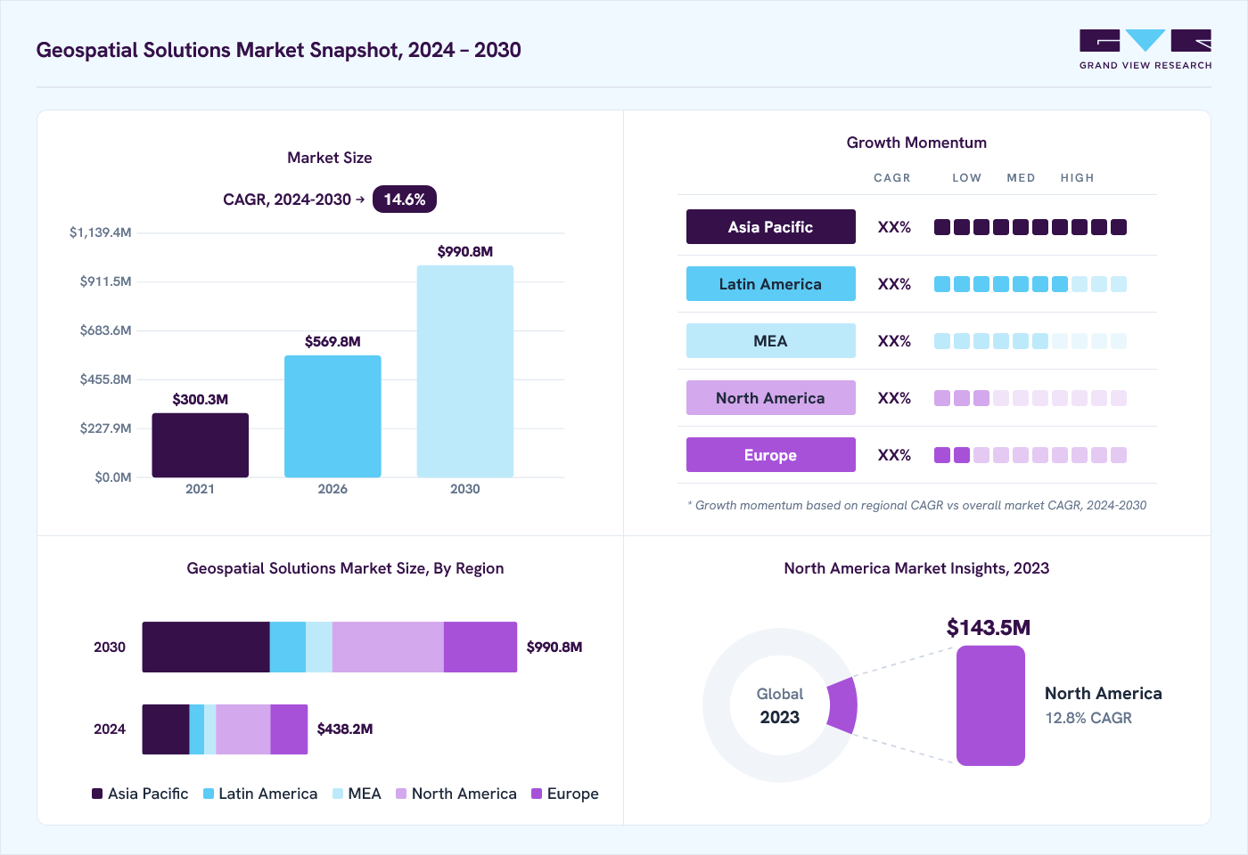
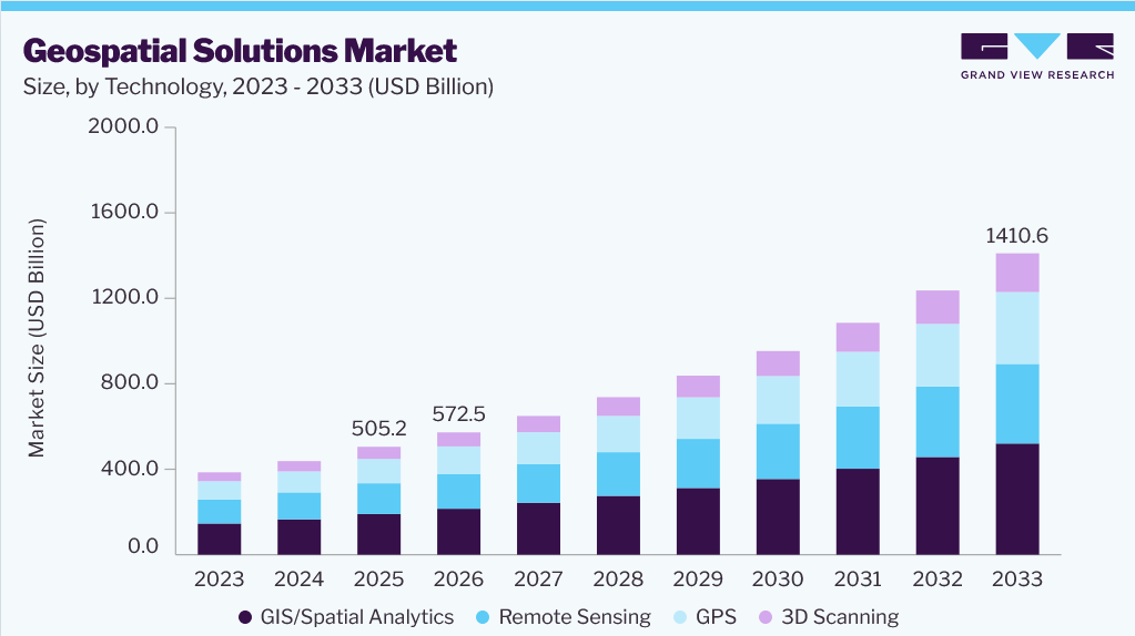
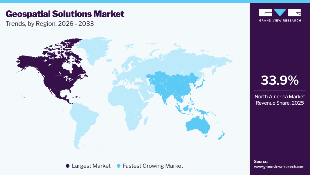
The global geospatial solutions market size was estimated at USD 505.2 billion in 2025 and is projected to grow from USD 572.5 billion in 2026 to USD 1,410.6 billion by 2033, growing at a CAGR of 13.7% from 2026 to 2033. North America dominated the global market with the largest revenue share of 33.9% in 2025. The geospatial solutions market is driven by the increasing adoption of geographic information systems (GIS), the growing integration of artificial intelligence, cloud computing, and remote sensing technologies, and the rising demand for real-time location intelligence.
 Source: Grand View Research, IR Documents, Primary Interviews, Paid DatabasesTo learn more about this report,
 Download Free Sample Report
 Key Market Trends & Insights
- By technology: The GIS/spatial analytics segment dominated the market, with a share of 37.7% in 2025.
- By component: The hardware segment accounted for the largest market share of 37.3% in 2025.
- By application, Surveying & mapping segment held the largest market share in 2025.
- By end use, Infrastructural development segment dominated the market in 2025.
Regional Highlights
- Largest regional market: North America (33.9% revenue share in 2025)
- Fastest growing regional market: Asia Pacific (highest CAGR 16.9%, 2026-2033)
- By Country: The U.S. held the largest market share in 2025
Market Size & Forecast
- Market size in 2025: USD 505.2 Billion
- Estimated market size in 2026: USD 572.5 Billion
- Projected market size by 2033: USD 1,410.6 Billion
- CAGR (2026-2033): 13.7%
Three ways to get this report
Buy it, customize it, or ask a question.Ask an Analyst
Analyst response in 1 business day
- AccessReport author, directly
- Reply timeWithin 1 working day
- No sales callDirect answer only
- FormatEmail reply
- CostFree, no cost
Get the Full Report
What the study covers
- FormatsPDF · Excel · Dashboard
- Timeline2026–2033 annual, 2025 base
- Coverage20+ countries, 5 regions
- Companies10+ key players profiled
Customize the Report
20% free customization
- IncludeCountries, segments, points
- TailorTo your product definition
- ExtendDeeper competitor detail
- OrA fully bespoke study
- Turnaround5–10 working days
 To learn more about this report, Download Free Sample Report
The expanding use of satellite imagery, drones, and IoT-enabled spatial data collection for infrastructure development, environmental monitoring, precision agriculture, and smart city initiatives is significantly accelerating the deployment of geospatial solutions. The increasing adoption of 3D mapping, spatial analytics, and cloud-based geospatial services is enhancing operational efficiency, improving decision-making, and creating new growth opportunities in the geospatial solutions market.Market Dynamics
The geospatial solutions market is witnessing robust growth due to the increasing availability of high-resolution Earth observation data, rapid advancements in geospatial data processing technologies, and the growing need for location-based decision support across public and private sectors. Rising investments in national mapping programs, infrastructure modernization, climate monitoring, and land management initiatives are encouraging organizations to adopt advanced geospatial platforms. The expanding use of geospatial solutions for asset tracking, utility network management, natural resource exploration, and emergency response is broadening market adoption. Continuous innovations in 3D geospatial visualization, edge computing, real-time spatial data processing, and interoperable geospatial platforms are enabling faster insights, improving operational resilience, and unlocking new opportunities for market expansion across diverse industries.
The increasing reliance on real-time location intelligence is becoming a major driver for the Geospatial Solutions Market as organizations require accurate spatial information to support planning, monitoring, and resource allocation. Advances in satellite positioning, Earth observation, remote sensing, and connected sensors enable continuous collection of geospatial data, allowing users to monitor changing environments with greater precision and speed than traditional mapping approaches.
Modern geospatial platforms transform vast volumes of spatial data into actionable insights through advanced visualization, predictive modeling, and automated analytics. Decision-makers can rapidly identify geographic patterns, assess risks, optimize asset utilization, and improve situational awareness. Organizations prioritize data-driven operations, and the demand for integrated geospatial solutions that deliver timely, accurate, and scalable location intelligence continues to grow across public and commercial applications.
The effectiveness of geospatial solutions depends heavily on the availability of accurate, current, and standardized spatial datasets. In many regions, mapping information remains incomplete, outdated, or inconsistent due to limited surveying, varying data-collection standards, and restricted access to high-resolution imagery. These limitations undermine the reliability of geospatial analysis and constrain the adoption of advanced spatial applications that require precise geographic information.
Data interoperability presents an additional challenge as organizations often manage information collected from multiple sources using different formats, coordinate systems, and quality standards. Considerable effort is required to validate, harmonize, and update these datasets before meaningful analysis can be performed. The resulting increase in project complexity, implementation time, and operational costs slows the deployment of comprehensive geospatial solutions in several markets.
The growing adoption of digital twin technology presents a significant opportunity for the Geospatial Solutions Market by enabling the creation of highly accurate virtual representations of physical assets and environments. Geospatial data serves as the foundation for these digital models by integrating mapping, terrain information, infrastructure layouts, and real-time sensor inputs to deliver continuously updated spatial representations for monitoring and analysis.
As digital twin platforms become increasingly sophisticated, the demand for precise geospatial data, 3D visualization, and spatial analytics continues to rise. Organizations are investing in advanced mapping technologies, LiDAR, drone-based surveys, and cloud-based geospatial platforms to improve simulation accuracy and operational visibility. This convergence is enabling more informed planning, predictive maintenance, infrastructure optimization, and lifecycle management, creating substantial opportunities for geospatial solution providers.
Market Concentration & Characteristics
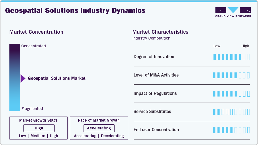
The geospatial solutions market is moderately concentrated, with leading geospatial software providers, satellite imagery companies, positioning technology developers, mapping platform vendors, and spatial analytics specialists competing across a wide range of applications. The market is experiencing rapid expansion driven by increasing investments in digital infrastructure, rising adoption of location intelligence, and growing demand for high-precision spatial data and operational optimization. Companies are focusing on AI-enabled geospatial analytics, cloud-native GIS platforms, strategic collaborations, and acquisitions to strengthen their technology portfolios and expand global market presence. Vendors are also investing in high-resolution satellite imaging, LiDAR technologies, real-time geospatial data processing, and digital twin capabilities to improve spatial accuracy, automate workflows, and enhance decision-making across location-based applications.
The market is characterized by a high degree of innovation, driven by continuous advancements in Earth observation technologies, 3D geospatial visualization, and cloud-based spatial computing platforms. Merger and acquisition activity remains moderately high, with established geospatial technology providers acquiring specialized remote sensing, drone mapping, spatial analytics, and location intelligence companies. The threat from substitutes remains low because conventional mapping and manual surveying methods cannot match the accuracy, scalability, automation, and real-time analytical capabilities offered by modern geospatial solutions. Regulatory impact remains high due to evolving geospatial data governance policies, satellite imagery regulations, national security requirements, and data privacy standards governing location-based information. Increasing investments in digital twin ecosystems, smart infrastructure initiatives, autonomous navigation technologies, and next-generation geospatial intelligence platforms are expected to further accelerate the development of the geospatial solutions market.
 To learn more about this report, Download Free Sample Report
 These technologies significantly enhance market capabilities by enabling more accurate and efficient data analysis, real-time processing, and predictive modeling. AI and machine learning are particularly driving the evolution of geospatial analytics by automating data processing and improving pattern recognition. Cloud computing facilitates scalable and flexible geospatial data management, allowing organizations to access and process large datasets without extensive infrastructure. As these technologies evolve, they are expected to further expand their applications and effectiveness across various industries.
The increasing global focus on smart city initiatives is a major driver of growth in the market. Smart cities rely heavily on geospatial technologies for urban planning, infrastructure management, and efficient resource allocation. These solutions provide critical insights into traffic patterns, energy consumption, environmental monitoring, and public safety, enabling city planners to make data-driven decisions for sustainable urban development. Integrating geospatial data with IoT (Internet of Things) devices is crucial in creating interconnected and intelligent urban environments.
The growing dependence on the defense and intelligence sectors is another key driver of market growth. Geospatial technologies are essential for military operations, surveillance, reconnaissance, and intelligence gathering, providing accurate and timely information for decision-making. Analyzing terrain, monitoring borders, tracking movements, and assessing threats in real-time are critical for national security. Furthermore, advancements in satellite imagery, UAV (Unmanned Aerial Vehicle) technology, and remote sensing are enhancing the precision and effectiveness of geospatial solutions in defense applications.
Analyst Perspective
The geospatial solutions market is experiencing strong expansion, driven by increasing demand for location intelligence, continuous advancements in Earth observation technologies, and the widespread adoption of GIS, remote sensing, and spatial analytics across public and private sectors. The growing implementation of cloud-based geospatial platforms, AI-powered spatial analysis, digital twin technologies, and real-time mapping solutions is enhancing operational planning, asset management, and infrastructure monitoring. As organizations increasingly prioritize data-driven decision-making, spatial visualization, and predictive geospatial insights, solution providers are well-positioned to capitalize on emerging opportunities, thereby reinforcing long-term market expansion and sustained revenue generation across the global geospatial ecosystem.
Technology Insights
Based on technology, the GIS/geospatial analytics segment led the market with the largest revenue share of 37.7% in 2025 and is expected to grow at a considerable CAGR over the forecast period. The market is driven by the increasing demand for data-driven decision-making across industries. GIS solutions become essential as businesses and governments prioritize efficient resource management, urban planning, and disaster response. Integrating AI and machine learning further enhances spatial analytics, providing deeper insights and predictive capabilities. Moreover, the rise of smart cities and IoT applications requires sophisticated spatial data analysis, making GIS indispensable for monitoring and optimizing urban environments, ultimately driving the market forward.
3D scanning is expected to register the fastest CAGR from 2024 to 2030. The market is growing due to its expanding construction, manufacturing, and heritage preservation applications. The demand for precise and detailed spatial data for modeling and simulation is fueling the adoption of 3D scanning in these sectors. In construction, 3D scanning enhances project planning and monitoring accuracy, reducing errors and costs. In addition, the technology's ability to capture complex geometries and environments drives its use in cultural heritage documentation and restoration, contributing to its market expansion.
Component Insights
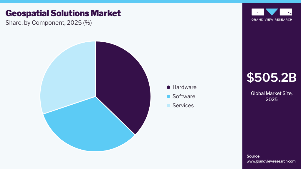
Based on component, the hardware segment dominated the market with the largest revenue share of 37.3% in 2025. The increasing need for sophisticated tools to manage and analyze large volumes of spatial data drives the market. The transition to cloud-based platforms and integration of AI and machine learning into geospatial software enhance functionality and accessibility. Industries such as urban planning, agriculture, and environmental monitoring rely heavily on geospatial software for real-time data analysis and decision-making. Continuous innovation and the growing demand for user-friendly interfaces further propel the growth of this segment.
 To learn more about this report, Download Free Sample Report
 Services are expected to register the fastest CAGR from 2024 to 2030. The market is growing rapidly due to the increasing reliance on specialized expertise for data collection, analysis, and integration. As organizations adopt geospatial technologies, there is a rising demand for consulting, implementation, and maintenance services to ensure the effective use of these tools. The complexity of geospatial data and the need for customized solutions drive the growth of professional services, including training, support, and managed services. This segment is further bolstered by the trend toward outsourcing geospatial operations to specialized providers.
Application Insights
Based on application, the surveying & mapping segment accounted for the largest market share of 31.6% in 2025. The market is driven by their critical role in infrastructure development, land management, and urban planning. The ongoing expansion of construction projects, both residential and commercial, requires accurate and detailed maps, fueling demand for these services. Furthermore, advancements in technology, such as drones and LiDAR, enhance the precision and efficiency of surveying and mapping activities. The need for updated geographic data for environmental monitoring and disaster management also contributes to the sustained growth of this segment.
Land management is expected to register the fastest CAGR from 2024 to 2030. An increasing need for efficient land use planning, property management, and sustainable development drives the market. Governments and private organizations are adopting geospatial technologies to monitor land use, assess property boundaries, and manage natural resources more effectively. Integrating GIS and remote sensing in land management provides accurate data for decision-making, helping balance development with environmental conservation. The rising focus on sustainable agriculture and urban expansion also fuels the demand for advanced land management solutions.
End Use Insights
Based on end use, the infrastructural development segment dominated the market with a revenue share of 19.1% in 2025. The market is growing as these technologies are essential for efficient infrastructure management, asset tracking, and service delivery. Geospatial tools enable utilities to optimize network operations, monitor assets in real-time, and respond quickly to outages or maintenance needs. Integrating GIS with smart grid technologies enhances the management of electricity, water, and gas distribution networks. As utilities face increasing pressure to improve service reliability and sustainability, the demand for geospatial solutions continues to rise.
The defense & intelligence segment is expected to grow at a CAGR of over 15% from 2024 to 2030. The market is driven by increasing reliance on these technologies for surveillance, reconnaissance, and mission planning. Geospatial solutions provide critical insights into terrain, troop movements, and potential threats, enabling more informed decision-making in military operations. Integrating satellite imagery, UAVs, and real-time data analytics enhances the precision and effectiveness of defense strategies. As global security challenges evolve, the demand for advanced geospatial tools in defense and intelligence continues to grow, driving market expansion.
Regional Insights
North America dominated the geospatial solutions market with the largest revenue share of 33.9% in 2025. The market is driven by advanced technological adoption and strong demand from key sectors like defense, transportation, and urban planning. The region's robust infrastructure and government initiatives, such as smart city projects and environmental monitoring programs, fuel market growth. Moreover, the presence of leading geospatial technology companies and a high level of R&D investment further bolster innovation and market expansion. The increasing use of geospatial analytics in business intelligence and disaster management also contributes to the region's growth.
 To learn more about this report, Download Free Sample Report
 U.S. Geospatial Solutions Market Trends
The geospatial solutions market in the U.S. held the largest share in the North America region in 2025. The market is growing due to significant investments in defense, smart cities, and infrastructure development. The federal government’s focus on enhancing national security and emergency response systems drives demand for advanced geospatial technologies. In addition, the U.S. leads in technological innovation, with widespread adoption of AI, machine learning, and big data analytics in geospatial applications. The country’s dynamic real estate, energy, and transportation sectors also contribute to the growth, as they increasingly rely on geospatial data for efficient planning, resource management, and decision-making.
Asia Pacific Geospatial Solutions Market Trends
The geospatial solutions market in Asia Pacific accounted for a significant revenue share of over 27% in 2023. Large-scale infrastructure projects, urbanization, and smart city initiatives in countries like China and India drive the market. The region’s growing economies are investing heavily in transportation, utilities, and environmental monitoring, increasing the demand for geospatial technologies. Furthermore, government policies promoting digital transformation and integrating advanced technologies like AI and IoT in geospatial applications further fuel market growth. The region's diverse topography and climate challenges also drive the adoption of geospatial solutions for disaster management and agriculture.
Japan geospatial solutions market is estimated to grow significantly from 2024 to 2030. The country's focus on disaster management, urban planning, and technological innovation drives the market. Japan's vulnerability to natural disasters like earthquakes and tsunamis necessitates advanced geospatial tools for risk assessment, early warning systems, and recovery planning. The government's smart city initiatives and infrastructure modernization contribute to market growth. Moreover, Japan's leadership in robotics, AI, and precision mapping technology and its strong research and development capabilities foster continuous innovation in geospatial solutions.
The geospatial solutions market in India is estimated to record a notable CAGR from 2024 to 2030. The market is growing due to the government’s focus on digital transformation, smart cities, and infrastructure development. Initiatives like Digital India and the Smart Cities Mission drive the adoption of geospatial technologies for urban planning, utility management, and disaster preparedness. The country’s vast and diverse geography and rapid urbanization necessitate efficient land use and resource management, further boosting demand. Furthermore, the rising agricultural sector increasingly utilizes geospatial tools for precision farming, contributing to the market's expansion in India.
China geospatial solutions market had the largest revenue share in 2023. The country’s massive infrastructure projects, urbanization, and government-led initiatives like the Belt and Road Initiative drive the market. The government's emphasis on smart cities and environmental monitoring is increasing the adoption of geospatial technologies. In addition, China's significant investments in satellite technology, remote sensing, and AI integration are enhancing the capabilities of geospatial solutions. The growing demand for advanced mapping, land management, disaster response tools, and China's industrial and agricultural sectors further fuels market growth.
Europe Geospatial Solutions Market Trends
The geospatial solutions market in Europe is anticipated to grow at a moderate CAGR of 11.9% from 2024 to 2030. The market is driven by strong demand from environmental monitoring, transportation, and urban planning sectors. The region’s commitment to sustainability and climate action initiatives, including the European Green Deal, accelerates the adoption of geospatial technologies for monitoring and managing natural resources. Furthermore, Europe’s advanced technological infrastructure and government support for smart city projects and digital transformation foster market growth. The presence of leading geospatial companies and collaborative research initiatives across the EU further enhance innovation and market expansion.
France geospatial solutions market accounted for a significant revenue share in 2023. The country’s emphasis on environmental sustainability, urban planning, and infrastructure modernization fuels the market. The French government’s commitment to climate action and renewable energy projects drives the adoption of geospatial technologies for monitoring and managing natural resources. Moreover, France’s robust transportation and agriculture sectors rely on geospatial data for efficient planning and operations. The country’s active participation in European Union geospatial initiatives and collaborative research programs also contributes to innovation and growth in the market.
The geospatial solutions market in the UK is estimated to grow at the highest CAGR from 2024 to 2030. The market is driven by strong demand in sectors like transportation, urban planning, and environmental monitoring. The UK government’s focus on smart city development and infrastructure projects, such as the High-Speed Rail (HS2) initiative, is increasing the use of geospatial technologies. In addition, the UK’s advanced research capabilities and the integration of AI and big data analytics into geospatial applications are fostering innovation. The country's commitment to sustainability and climate change mitigation also drives demand for geospatial solutions in environmental management.
Germany geospatial solutions market is estimated to grow at a moderate CAGR from 2024 to 2030. The market is growing due to the country’s strong industrial base, infrastructure development, and commitment to sustainability. The German government’s focus on smart manufacturing (Industry 4.0) and urban planning drives the adoption of geospatial technologies for optimizing production processes and managing urban growth. Furthermore, Germany’s leadership in the automotive and transportation sectors increases demand for geospatial data in logistics, navigation, and infrastructure management. The country’s emphasis on environmental protection and renewable energy also contributes to the market’s expansion, as geospatial tools are essential for monitoring and managing these initiatives.
Middle East & Africa (MEA) Geospatial Solutions Market Trends
The geospatial solutions market in the Middle East and Africa (MEA) region is estimated to grow a significant CAGR of 14% from 2024 to 2030. The market is expanding due to the region’s focus on infrastructure development, urbanization, and resource management. Countries in the Gulf Cooperation Council (GCC) are investing heavily in smart city projects, driving the adoption of geospatial technologies for urban planning and utility management. Moreover, the region’s vast natural resources, including oil and gas, necessitate advanced geospatial tools for exploration, monitoring, and sustainable management. The growing need for efficient land use and environmental monitoring in the face of climate challenges further fuels market growth in the MEA.
Saudi Arabia geospatial solutions market accounted for a considerable revenue share in 2023. The market is driven by the country’s ambitious Vision 2030 initiative, which aims to diversify the economy and develop infrastructure. The government’s focus on smart city projects, such as NEOM, and large-scale infrastructure development is increasing the demand for geospatial technologies. In addition, Saudi Arabia’s oil and gas sector relies heavily on geospatial solutions for exploration, production, and environmental management. Integrating advanced technologies like AI and IoT into geospatial applications further enhances the country’s capabilities in land management and resource optimization.
Key Geospatial Solutions Company Insights
Some key players operating in the market include Microsoft Corporation, Oracle Corporation, and Google LLC.
-
Microsoft Corporation's strategic growth in the market focuses on leveraging its cloud platform, Azure, to integrate geospatial analytics with AI and machine learning. Through partnerships with geospatial technology leaders, Microsoft enhances its mapping and location-based services, offering scalable solutions for industries like defense, urban planning, and environmental monitoring. By embedding geospatial data into Azure services, Microsoft enables advanced spatial analytics, driving innovation in smart cities, logistics, and IoT, reinforcing its position as a key player in geospatial solutions.
-
Google LLC's strategic growth in the market is driven by its dominance in mapping and location services through Google Maps and Google Earth. The company leverages its cloud platform, Google Cloud, to offer geospatial analytics and location-based services integrated with AI and big data capabilities. Google's investments in AI-driven geospatial data processing, partnerships with industry leaders, and continuous innovation in 3D mapping, AR, and VR technologies enhance its retail, transportation, and urban planning offerings, solidifying its geospatial market leadership.
Living Map, Mappedin Inc., and TomTom International BV are some of the emerging market participants.
-
Living Map's strategic growth in the market focuses on providing real-time, location-based mapping solutions tailored to smart cities, transportation hubs, and large venues. The company leverages advanced geospatial data analytics to deliver dynamic, interactive maps that enhance user experiences and operational efficiency. Through partnerships with tech giants and transportation authorities, Living Map integrates its solutions with IoT and mobile platforms, enabling seamless indoor-outdoor navigation. This approach positions Living Map as a key player in delivering innovative, customized geospatial solutions for urban environments and complex infrastructures.
-
TomTom International BV's strategic growth in the market is centered around its expertise in mapping, navigation, and location-based services. The company focuses on developing highly accurate maps and advanced geospatial data platforms, crucial for autonomous driving, smart mobility, and logistics. TomTom strengthens its position through strategic partnerships with automotive, tech, and logistics companies, integrating real-time traffic data, AI, and machine learning to enhance its geospatial offerings. TomTom remains a significant player in the geospatial market by continuously innovating in areas like HD mapping and location-based APIs.
Key Geospatial Solutions Companies:
The following key companies have been profiled for this study on the geospatial solutions market.
- Pix4D
- Microsoft Corporation
- Uber Technologies Inc.
- L3Harris Geospatial Solutions Inc.
- TomTom International BV
- Living Map
- Google LLC
- Mappedin Inc.
- Bentley Systems Inc.
- SAP SE
- Apple Inc.
- GIS Cloud Ltd.
- General Electric Company
- Oracle Corporation
- Telenav Inc.
- Trimble Inc.
- Pitney Bowes Inc.
- Hexagon AB
Recent Developments
-
In July 2024, Esri collaborated with Microsoft Corporation to integrate its spatial analytics technology with Fabric, Microsoft's unified analytics SaaS platform. Data experts, including analysts, data scientists, engineers, and executives, could seamlessly use Esri's advanced spatial analytics tools and visualizations within Microsoft Fabric through this integration. This collaboration enabled powerful spatial analytics to be easily shared across organizational tools such as Microsoft Fabric, Power BI, and Esri's ArcGIS environment.
-
In February 2024, GE Vernova announced the release of Proficy for Sustainability Insights, a new AI-based software solution aimed at helping manufacturers achieve sustainability goals while maximizing productivity and profitability. The software integrates operational and sustainability data, enabling industrial companies to use resources more efficiently and manage climate metrics required for regulatory compliance across plants or enterprises.
Geospatial Solutions Market Report Scope
Report Attribute
Details
Market size in 2025
USD 505.2 Billion
Estimated market size in 2026
USD 572.5 Billion
Projected market size by 2033
USD 1,410.6 Billion
Growth rate
CAGR of 13.7% from 2026 to 2033
Base year for estimation
2025
Historical data
2021 - 2024
Forecast period
2026 - 2033
Quantitative units
Revenue in USD Billion, and CAGR from 2026 to 2033
Report coverage
Revenue forecast, company ranking, competitive landscape, growth factors, and trends
Segments covered
Technology, component, application, end use, and region
Regional scope
North America; Europe; Asia Pacific; Latin America; MEA
Country scope
U.S.; Canada; Mexico; U.K.; Germany; France; China; Japan; India; South Korea; Australia; Brazil; Saudi Arabia; UAE; South Africa
Key companies profiled
Pix4D; Microsoft Corporation; Uber Technologies Inc.; L3Harris Geospatial Solutions Inc.; TomTom International BV; Living Map; Google LLC; Mappedin Inc.; Bentley Systems Inc.; SAP SE; Apple Inc.; GIS Cloud Ltd.; General Electric Company; Oracle Corporation; Telenav Inc.; Trimble Inc.; Pitney Bowes Inc.; Hexagon AB
Customization scope
Free report customization (equivalent up to 8 analysts' working days) with purchase. Addition or alteration to country, regional & segment scope.
Pricing and purchase options
Avail customized purchase options to meet your exact research needs. Explore purchase options
Global Geospatial Solutions Marker Report Segmentation
This report forecasts revenue growth at global, regional, and country levels and provides an analysis of the latest industry trends in each of the sub-segments from 2021to 2033. For this study, Grand View Research has segmented the global geospatial solutions market report based on technology, component, application, end use, and region:
-
Technology Outlook (Revenue, USD Million, 2021 - 2033)
-
GIS/Geospatial Analytics
-
Remote Sensing
-
GPS
-
3D Scanning
-
-
Component Outlook (Revenue, USD Million, 2021 - 2033)
-
Hardware
-
Software
-
Services
-
-
Application Outlook (Revenue, USD Million, 2021 - 2033)
-
Surveying & Mapping
-
Geovisualization
-
Planning & Analysis
-
Land Management
-
Others
-
-
End Use Outlook (Revenue, USD Million, 2021 - 2033)
-
Utility
-
Business
-
Transportation
-
Defense & Intelligence
-
Infrastructure Development
-
Natural Resources
-
Others
-
-
Regional Outlook (Revenue, USD Million, 2021 - 2033)
-
North America
-
U.S.
-
Canada
-
Mexico
-
-
Europe
-
Germany
-
UK
-
France
-
-
Asia Pacific
-
China
-
Japan
-
India
-
South Korea
-
Australia
-
-
Latin America
-
Brazil
-
-
Middle East and Africa (MEA)
-
UAE
-
Saudi Arabia
-
South Africa
-
-
Research Methodology
The geospatial solutions market figures in this report are based on a proven research process that combines executive interviews with secondary research from proprietary databases, company filings, and recognized regulatory and institutional sources. Market size is built through value-chain sizing - reconciling supply-side and demand-side estimates - and triangulated with bottom-up and top-down approaches. Every estimate passes multiple levels of expert validation before publication, with each geospatial solutions segment quantified using the revenue-capture definitions in the table below.
Segment Definition
Segment - Technology
Revenue capture definition
GIS/Geospatial Analytics
Revenue is generated from software platforms that capture, analyze, visualize, and manage spatial data for location-based decision-making. This segment is driven by increasing adoption of GIS, spatial intelligence, predictive analytics, and cloud-based mapping solutions.
Remote Sensing
Revenue is generated from technologies that acquire geographic information using satellites, drones, and aerial imaging systems. This segment is driven by increasing demand for environmental monitoring, infrastructure assessment, resource management, and disaster response applications.
GPS
Revenue is generated from positioning technologies that provide accurate location, navigation, and tracking capabilities. This segment is driven by growing adoption of GNSS-enabled devices, fleet management solutions, asset tracking systems, and precision navigation applications.
3D Scanning
Revenue is generated from technologies that capture accurate three-dimensional representations of physical environments and assets. This segment is driven by increasing demand for digital twins, infrastructure documentation, construction planning, and high-precision spatial modeling.
Segment - Component
Revenue capture definition
Hardware
Revenue is generated from geospatial equipment including GNSS receivers, drones, LiDAR systems, surveying instruments, and imaging sensors. This segment is driven by increasing investments in high-precision data acquisition and field surveying technologies.
Software
Revenue is generated from GIS platforms, spatial analytics software, mapping applications, and geospatial data management solutions. This segment is driven by increasing demand for cloud-based analytics, visualization tools, and location intelligence capabilities.
Services
Revenue is generated from consulting, system integration, surveying, mapping, data processing, and maintenance services. This segment is driven by increasing demand for customized geospatial implementations, technical expertise, and managed spatial data solutions.
Segment - Application
Revenue capture definition
Surveying & Mapping
Revenue is generated from solutions supporting land surveys, topographic mapping, cadastral mapping, and engineering measurements. This segment is driven by increasing infrastructure projects, land administration requirements, and demand for accurate spatial information.
Geovisualization
Revenue is generated from platforms that transform geospatial data into interactive maps, dashboards, and three-dimensional visualizations. This segment is driven by increasing demand for intuitive spatial insights and real-time geographic data interpretation.
Planning & Analysis
Revenue is generated from geospatial solutions supporting spatial planning, predictive modeling, and decision-support applications. This segment is driven by increasing demand for data-driven planning, infrastructure optimization, and efficient resource allocation strategies.
Land Management
Revenue is captured through solutions that support land administration, property management, zoning, and environmental monitoring activities. This segment is driven by increasing demand for accurate land records, regulatory compliance, and sustainable resource management.
Others
Revenue is generated from specialized geospatial applications including emergency response, environmental monitoring, asset inspection, and location-based services. This segment is driven by expanding adoption of spatial technologies across emerging operational use cases.
Segment - End Use
Revenue capture definition
Utility
Revenue is captured through geospatial solutions supporting utility asset mapping, network monitoring, and infrastructure maintenance. This segment is driven by increasing demand for grid modernization, outage management, and efficient utility network operations.
Business
Revenue is generated from location intelligence platforms supporting market analysis, site selection, customer analytics, and operational planning. This segment is driven by increasing adoption of spatial insights for strategic business decision-making and resource optimization.
Transportation
Revenue is generated from geospatial solutions supporting navigation, route optimization, traffic management, and fleet tracking. This segment is driven by increasing demand for intelligent transportation systems and real-time mobility management capabilities.
Defense & Intelligence
Revenue is generated by geospatial technologies that support surveillance, mission planning, terrain analysis, and situational awareness. This segment is driven by increasing investments in geospatial intelligence, national security, and advanced defense mapping capabilities.
Infrastructure Development
Revenue is captured through geospatial solutions supporting construction planning, engineering design, asset monitoring, and project management. This segment is driven by increasing investments in infrastructure modernization and digital construction workflows.
Natural Resources
Revenue is generated by geospatial technologies that support mining, forestry, agriculture, water management, and environmental monitoring. This segment is driven by increasing demand for sustainable resource management and accurate spatial assessment capabilities.
Others
Revenue is captured from geospatial solutions serving healthcare, telecommunications, public safety, education, and environmental applications. This segment is driven by expanding adoption of location intelligence across diverse organizational and government operations.
Estimation Model
Layer Name
Key Question
Description
Geospatial Demand Layer
Who are the potential adopters?
Identifies the total addressable customer base requiring geospatial solutions, including government agencies, utility providers, transportation operators, defense organizations, construction firms, natural resource companies, telecommunications operators, environmental agencies, and enterprises seeking location intelligence, mapping, monitoring, and spatial analytics for operational and strategic decision-making.
Geospatial Infrastructure Enablement Layer
Who can deploy Geospatial Solutions?
Adoption is influenced by the availability of satellite infrastructure, GNSS networks, cloud computing platforms, geospatial databases, remote sensing capabilities, drone ecosystems, LiDAR technologies, AI-powered analytics, and investments in digital infrastructure that enable efficient spatial data collection, processing, visualization, and analysis.
Spatial Application Deployment Layer
Where are Geospatial Solutions actively utilized?
Applies adoption levels across environments requiring location intelligence and spatial analysis, including land surveying, urban planning, transportation networks, utility asset management, environmental monitoring, agriculture, mining operations, disaster management, defense surveillance, construction sites, smart city initiatives, and infrastructure development projects.
Revenue Generation Layer
How is revenue generated?
Revenue is generated through GIS software platforms, remote sensing solutions, GPS and positioning technologies, 3D mapping platforms, surveying equipment, cloud-based geospatial services, consulting and system integration services, data licensing, maintenance contracts, and recurring revenue from geospatial software subscriptions and managed services.
Delivered Customizations
This report has been delivered with the following In-depth customizations
Client Request
Customization Delivered
Value Adds
Enterprise GIS Deployment & Spatial Analytics Optimization Assessment
Conducted detailed evaluation of enterprise GIS platforms across utilities, transportation, infrastructure, and public administration, integrating cloud GIS, AI-powered spatial analytics, geospatial databases, and visualization tools to improve operational planning and location intelligence.
Improves spatial decision-making, enhances operational visibility, optimizes resource allocation, and strengthens infrastructure planning.
Remote Sensing Integration & Infrastructure Monitoring Strategy
Assessed deployment of remote sensing solutions across infrastructure assets, environmental monitoring, land management, and disaster response, integrating satellite imagery, drone mapping, LiDAR technologies, and real-time geospatial analytics to improve monitoring accuracy and asset management.
Enhances monitoring accuracy, improves asset visibility, enables proactive maintenance, and supports informed planning decisions.
Digital Twin Mapping & Geospatial Intelligence Implementation Strategy
Evaluated implementation of digital twin platforms, 3D mapping technologies, AI-powered geospatial intelligence, and cloud-based spatial data management frameworks to improve infrastructure visualization, predictive analysis, operational efficiency, and lifecycle asset management capabilities.
Enables predictive insights, improves infrastructure visualization, enhances planning efficiency, and supports intelligent asset management.
Frequently Asked Questions About This Report
Key factors that are driving the geospatial solutions market growth include the rapid advancements in technologies such as artificial intelligence (AI), machine learning, and cloud computing.
The global geospatial solutions market size was valued at USD 505.2 billion in 2025 and is estimated at USD 572.5 billion for 2026.
The global geospatial solutions market is expected to grow at a CAGR of 13.7% from 2026 to 2033, reaching USD 1,410.6 billion by 2033.
North America dominated with a 33.9% revenue share in 2025.
Some key players operating in the geospatial solutions market include Pix4D, Microsoft Corporation, Uber Technologies Inc., L3Harris Geospatial Solutions Inc., TomTom International BV, Living Map, Google LLC, Mappedin Inc., Bentley Systems Inc., SAP SE, Apple Inc., GIS Cloud Ltd., General Electric Company, Oracle Corporation, Telenav Inc., Trimble Inc., Pitney Bowes Inc., Hexagon AB.
About the Author(s)
Next Generation Technologies Research Team
Technology · Next Generation TechnologiesThis report was authored by the next generation technologies research team at Grand View Research - comprising two research analysts, one senior research analyst, and one industry expert - with specialized expertise in the next generation technologies segment of the technology industry. All findings are based on proprietary technology databases, executive interviews, and regulatory analysis, subject to internal peer review prior to publication.
Last Updated:
Speak to Analyst

Customize this report to your needs - add regions, segments, or data points, with 20% free customization.
Or view our licence options:


ISO 9001:2015 & 27001:2022 Certified
We are GDPR and CCPA compliant! Your transaction & personal information is safe and secure. For more details, please read our privacy policy.


